Old Maps of El Dorado County, California for Academic Research
Study the evolution of El Dorado County with 315 high-resolution historic maps. Whether you're teaching, researching, or modeling changes in land use, these maps provide essential visual documentation of urban, environmental, and geographic change.
- Analyze long-term change: Track patterns in development, transportation, and natural features.
- Ideal for environmental or urban studies: Support academic projects with primary historical map data.
- Use in the classroom or lab: Educators and researchers rely on these maps to bring historical context to life.
These maps are a powerful tool for teaching, research, and visualizing how El Dorado County has changed over the decades.
El Dorado County, CA maps
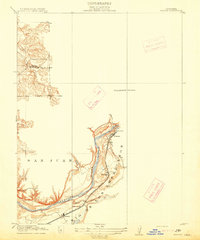
(315)- 1889 Map of Pyramid Peak, 1954 Print
 1889 Pyramid Peak1954 Print · USGSThe high Sierra and Lake Tahoe shores appear here in the late nineteenth century, long before the arrival of modern highways. Researchers can locate early alpine outposts and family homesteads like Uncle Toms Cabin, Glen Alpine Springs, and Yanks.
 - 1889 Map of Markleeville, 1954 Print
 1889 Markleeville1954 Print · USGSThe high Sierra and Carson Valley come alive in the late nineteenth century, showing a network of stage stops and mountain camps. Researchers can trace early settlements and family landmarks such as Markleeville, Walleys Hot Springs, and Tim Smiths.
 - 1891 Map of Sacramento
 1891 Sacramento1891 Print · USGSNorthern California foothills and the valley plains emerge in the late nineteenth century as the rail-and-road network expands. Trace early family landmarks and river crossings like Mormon Island, Whitney Ranch, and the historic Rattlesnake Bridge.
 - 1891 Map of Markleeville
 1891 Markleeville1891 Print · USGSThe High Sierra and Carson Valley frontier come alive in the late nineteenth century, showing the rugged borderlands of California and Nevada. Researchers can trace early waystations and family outposts like Twelve Mile House, Hangman's Bridge, and Walleys Hot Springs.
 - 1891 Map of Colfax
 1891 Colfax1891 Print · USGSThe Sierra Nevada foothills and high ridges of the Gold Country appear in this late nineteenth-century survey during a peak era of mining and rail expansion. Genealogists and historians can trace old hydraulic mining sites like Malakoff and mountain settlements such as North Bloomfield and Gold Run.
 - 1891 Map of Truckee
 1891 Truckee1891 Print · USGSThe High Sierra and Lake Tahoe shoreline are captured here in the late nineteenth century as the railroad transformed the mountain economy. Trace the original path of the Central Pacific Railroad through Donner Pass or locate early lakeside landings at Tahoe City and McKinney.
 - 1891 Map of Placerville
 1891 Placerville1891 Print · USGSEl Dorado County was a thriving network of mining camps and timber mills in the 1890s. Genealogists can trace family roots through old landmarks like Diamond Springs, Coloma, and the Placerville and Sacramento Railroad.
 - 1891 Map of Pyramid Peak
 1891 Pyramid Peak1891 Print · USGSThe High Sierra in the early 1890s appears as a land of early resorts and rugged outposts along the southwest shores of Lake Tahoe. Genealogists and historians can locate early family-named settlements like Phillips and trace the historic Strawberry Valley Road past Tragedy Spring.
 - 1892 Map of Sacramento
 1892 Sacramento1892 Print · USGSThe rail-and-river economy of Northern California is on full display in the 1890s as the Central Pacific Railroad links the valley to the foothills. Genealogists and historians can trace early settlements like Mormon Island, Salmon Falls, and the Whitney's Ranch before modern development changed the landscape.5 unique versions available
 - 1892 Map of Placerville
 1892 Placerville1892 Print · USGSEl Dorado County is documented during the late nineteenth-century mining era, showing the rugged network of river canyons and early mountain roads. Researchers can trace the Sacramento and Placerville Railroad or locate historic sites like the Mile Hill Toll House and Spanish Diggings.
 - 1892 Map of Colfax
 1892 Colfax1892 Print · USGSThe Sierra Nevada foothills thrive with mining and rail activity in the 1890s as the gold industry matures. Genealogists and historians can trace old claims and communities like North Bloomfield, Alleghany, and the Alaska Mine along the Central Pacific Railroad.
 - 1893 Map of Markleeville
 1893 Markleeville1893 Print · USGSThe high Sierra and Carson Valley come alive in the 1890s, capturing the early settlements and mountain passes of the California-Nevada borderlands. Genealogists and historians can trace pioneer landmarks like Walleys Hot Springs, Twelve Mile House, and Sierra House during a time of early ranching and transit.9 unique versions available
 - 1893 Map of Placerville
 1893 Placerville1893 Print · USGSEl Dorado and Placer counties during the late nineteenth-century mining era reveal a landscape of deep canyons and booming industrial camps. Genealogists and historians can trace the Sacramento and Placerville Railroad to its terminus or locate early operations like Mammoth Mine and Spanish Diggings.9 unique versions available
 - 1893 Map of Truckee
 1893 Truckee1893 Print · USGSHigh Sierra transit and industry dominate this late nineteenth-century landscape as the Central Pacific Railroad crosses the divide. Trace the early footprints of Tahoe City, the remote lodges at Rubicon Springs, and the timber operations around Boca.
 - 1893 Map of Sacramento, 1900 Print
 1893 Sacramento1900 Print · USGSThe Sacramento Valley and Sierra foothills come alive in this late nineteenth-century survey during the height of the railroad era. Researchers can trace the early layout of Roseville, locate family landmarks like Whitney's Ranch, or follow the Placerville Road through the gold country.
 - 1894 Map of Colfax
 1894 Colfax1894 Print · USGSThe northern Sierra Nevada's mining heartland is mapped here during the late nineteenth-century gold boom. Researchers can trace the paths of the Central Pacific Railroad and locate historic claims like the Delhi Mine and Derbec Mine.
 - 1895 Map of Pyramid Peak
 1895 Pyramid Peak1895 Print · USGSThe high Sierra peaks and the southwestern shores of Lake Tahoe are captured here in the late nineteenth century. Researchers can trace early mountain transit and remote outposts like Uncle Toms Cabin, Slippery Ford, and Glen Alpine Springs.2 unique versions available
 - 1895 Map of Truckee
 1895 Truckee1895 Print · USGSThe high Sierra and Lake Tahoe's western shore are captured in the late 1800s as the railroad fueled new mountain industry. Trace the historic Central Pacific route past Boca or locate early lakeside spots like McKinney and Rubicon Springs.9 unique versions available
 - 1896 Map of Pyramid Peak, 1905 Print
 1896 Pyramid Peak1905 Print · USGSThe high Sierra Nevada backcountry of El Dorado County is captured here in the late nineteenth century, showing a landscape of early trail stops and timber camps. Researchers can trace historic routes to Slippery Ford, find the location of Uncle Toms Cabin, or locate early lakeside destinations like Tallac and Yanks.7 unique versions available
 - 1898 Map of Colfax
 1898 Colfax1898 Print · USGSThe Sierra Nevada gold fields come to life in the late nineteenth century as hydraulic mining reaches its peak. Genealogists and researchers can trace the early industrial footprint of the Malakoff Mine and settlements like Alleghany and North Bloomfield.
 - 1900 Map of Colfax
 1900 Colfax1900 Print · USGSThe Sierra Nevada foothills and high peaks are shown at the turn of the century as the mining economy and transcontinental rail travel reached their maturity. Researchers can trace historic industrial sites like the Alaska Mine, remote camps such as Moores Flat, and the path of the Southern Pacific RR.
 - 1902 Map of Colfax
 1902 Colfax1902 Print · USGSGold-rush towns and hydraulic mining sites define this portion of the Sierra Nevada at the turn of the century. Genealogists and historians can trace the foundations of North Bloomfield, locate the remote Alaska Mine, or follow the Southern Pacific through Emigrant Gap.7 unique versions available
 - 1914 Map of Folsom
 1914 Folsom1914 Print · USGSThe American River gold country comes alive in this early century survey of the region surrounding Folsom. Researchers can trace the path of the Placerville Branch railroad or locate early industrial sites like the Power House and a large river Dredge.2 unique versions available
 - 1932 Map of Truckee
 1932 Truckee1932 Print · USGSThe high Sierra and Lake Tahoe's western shore are captured here in the early thirties as the region balanced industrial mining and timber with a growing seasonal economy. Trace early lakeside developments from Tahoe Tavern to Meeks Bay PO, or locate historical sites like the Walker Mine and Donner Monument.
 - 1938 Map of Colfax
 1938 Colfax1938 Print · USGSThe Sierra Nevada's gold and timber country comes into focus in the late 1930s, showing a landscape defined by deep river canyons and industrial high-country camps. Researchers can locate remote sites like the Sixteen to One Mine, the North Bloomfield Ranger Station, and vanished settlements like Lake City.3 unique versions available
Showing maps 1-25 of 315
Top cities of El Dorado County
- El Dorado Hills historical maps
- South Lake Tahoe historical maps
- Cameron Park historical maps
- Placerville historical maps
- Pollock Pines historical maps
- Diamond Springs historical maps
See more
Frequently asked questions
- What are the different types of historical maps available for El Dorado County?
- What is the oldest map of El Dorado County?
- Where can I purchase historical maps of El Dorado County for my home or office?
- Where can I download high-res historical maps of El Dorado County?
- Are there historical topographic maps available for El Dorado County?
- Is there historical aerial imagery available for El Dorado County?
- Where are historical maps of El Dorado County sourced from?