1970s Maps of El Dorado County, California
Explore 8 historic maps of El Dorado County from the 1970s. These maps offer a rare glimpse into what life looked like during the 1970s — showing old roads, neighborhoods, homes, and landmarks that have changed or disappeared over time.
Whether you're researching your family's past, planning a metal detecting trip, or studying how El Dorado County's landscape evolved across the 1970s, these high-resolution maps are a powerful tool for exploring the history of this region.
- Focus on a specific era: All maps on this page are from the 1970s, giving you a focused view of this time period.
- See what’s changed: Compare century-old streets, trails, and buildings to today's modern landscape using overlays and satellite layers.
- Research with precision: Use these maps for genealogy, historical research, land use analysis, or educational projects.
- View, download, or print: Maps are fully viewable online in high resolution, and can be downloaded or printed for your own records.
Start exploring El Dorado County's history through authentic maps from the 1970s. This is your window into the past.
El Dorado County, CA maps
(8)- 1974 Map of South Lake Tahoe, 1977 Print
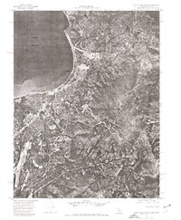 1974 South Lake Tahoe1977 Print · USGSThe California-Nevada border at the lake's southern edge comes into sharp focus during the mid-seventies, showing the density of mountain development. Trace the early layout of South Lake Tahoe and Stateline against the backdrop of the Carson Range.
 - 1975 Map of Folsom, 1978 Print
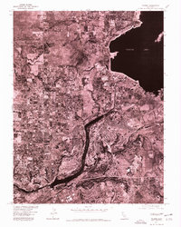 1975 Folsom1978 Print · USGSGreater Sacramento's transition toward modern suburban development is captured in the mid-1970s through this detailed aerial survey. Trace the growth of Folsom and Orangevale alongside the massive engineering of Folsom Lake and Lake Natoma.
 - 1975 Map of Auburn, 1981 Print
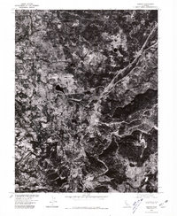 1975 Auburn1981 Print · USGSThe Placer County foothills in the mid-seventies are documented here through high-resolution aerial photography. Genealogists and historians can trace the footprint of Auburn, the Dewitt State Hospital grounds, and outlying locales like Clipper Gap.
 - 1976 Map of Placerville, 1994 Print
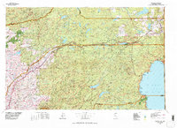
 1976 Placerville1994 Print · USGSEl Dorado County and the high Sierra Nevada are captured in the mid-seventies, showing the evolution of the Mother Lode from its mining roots to a modern recreational and timber hub. Genealogists can locate family names and old landmarks like Old Fort Jim, the Shingle Springs Indian Reservation, and the historic town of Fiddletown.2 unique versions available
 - 1977 Map of Truckee, 1978 Print
 1977 Truckee1978 Print · USGSThe High Sierra and Lake Tahoe regions come into focus in the late seventies, showing a landscape defined by massive reservoir projects and mountain transit. Genealogists and historians can trace the Southern Pacific rail line through Truckee or explore old mining districts near North Bloomfield and Colfax.2 unique versions available
 - 1979 Map of Bear River Reservoir
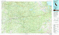
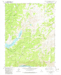 1979 Bear River Reservoir1979 Print · USGSAmador and El Dorado counties are shown here in the late 1970s, a period of managed wilderness and high-country water storage. Researchers can trace the development of the Bear River Reservoir and locate legacy sites like Podesta Camp, Camp Winton, and Onion Valley.4 unique versions available
 - 1979 Map of Caples Lake, 1980 Print
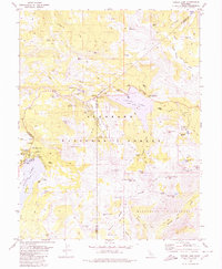 1979 Caples Lake1980 Print · USGSHigh Sierra history unfolds in the late seventies as the Kirkwood resort area takes shape alongside legacy pioneer routes. You can trace the Old Emigrant Trail, locate the Lost Cabin Mine, and find seasonal outposts like Schneider Camp.3 unique versions available
 - 1979 Map of Tragedy Spring, 1980 Print
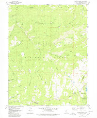 1979 Tragedy Spring1980 Print · USGSEl Dorado County high country in the late seventies reveals a landscape of pioneer memorials and early alpine recreation. Genealogists and hikers can trace historic sites like Maidens Grave, the Plasse (Silver Lake PO) settlement, and the namesake Tragedy Spring.2 unique versions available
End of results
Showing maps 1-8 of 8
Top cities of El Dorado County
- El Dorado Hills historical maps
- South Lake Tahoe historical maps
- Cameron Park historical maps
- Placerville historical maps
- Pollock Pines historical maps
- Diamond Springs historical maps
See more
Frequently asked questions
- What are the different types of historical maps available for El Dorado County?
- What is the oldest map of El Dorado County?
- Where can I purchase historical maps of El Dorado County for my home or office?
- Where can I download high-res historical maps of El Dorado County?
- Are there historical topographic maps available for El Dorado County?
- Is there historical aerial imagery available for El Dorado County?
- Where are historical maps of El Dorado County sourced from?