1940s Maps of Firebaugh, California
Explore 5 historic maps of Firebaugh from the 1940s. These maps offer a rare glimpse into what life looked like during the 1940s — showing old roads, neighborhoods, homes, and landmarks that have changed or disappeared over time.
Whether you're researching your family's past, planning a metal detecting trip, or studying how Firebaugh's landscape evolved across the 1940s, these high-resolution maps are a powerful tool for exploring the history of this region.
- Focus on a specific era: All maps on this page are from the 1940s, giving you a focused view of this time period.
- See what’s changed: Compare century-old streets, trails, and buildings to today's modern landscape using overlays and satellite layers.
- Research with precision: Use these maps for genealogy, historical research, land use analysis, or educational projects.
- View, download, or print: Maps are fully viewable online in high resolution, and can be downloaded or printed for your own records.
Start exploring Firebaugh's history through authentic maps from the 1940s. This is your window into the past.
Firebaugh, CA maps
(5)- 1941 Map of Firebaugh
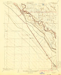 1941 Firebaugh1941 Print · USGSFresno and Madera counties are shown here just before the mid-century, defined by the irrigation canals and rail lines of the Central Valley. Researchers can trace the industrial footprint of the Standard Oil Pump Station and family landmarks like Helm Ranch.
 - 1946 Map of Firebaugh, 1954 Print
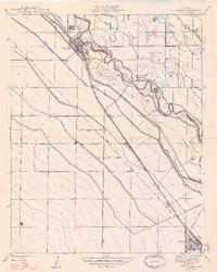
 1946 Firebaugh1954 Print · USGSThe Central Valley ranching and rail corridor comes to life in the mid-1940s as irrigation projects began reshuffling the landscape. Trace the Southern Pacific line through Firebaugh and Mendota, or locate family-named sites like Helm Ranch and Arbios.2 unique versions available
 - 1947 Map of Pozo Farm
 1947 Pozo Farm1947 Print · USGSThe San Joaquin Valley's intricate irrigation and rail network is captured here in the late 1940s. Researchers can trace early water management systems like Helm Canal and the Southern Pacific tracks near Pozo Farm.
 - 1947 Map of Firebaugh
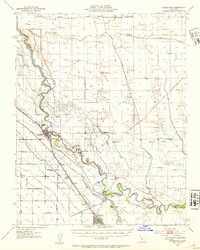
 1947 Firebaugh1947 Print · USGSFresno and Madera counties are seen here in the mid-1940s, where the river and rail lines defined the pace of valley life. Researchers can trace the Southern Pacific line between Firebaugh and Mendota, locating smaller sidings like Benito and Arbios.2 unique versions available
 - 1948 Map of Santa Cruz
 1948 Santa Cruz1948 Print · USGSThe Central Coast and San Joaquin Valley meet in this mid-century look at the region's agricultural and military geography. Genealogists and historians can trace the paths of El Camino Real, locate family farms near Hollister, or study the footprint of the Fort Ord Military Reservation.2 unique versions available
End of results
Showing maps 1-5 of 5
Top cities near Firebaugh
- Mendota historical maps
- Dos Palos historical maps
- South Dos Palos historical maps
- Tranquillity historical maps
Frequently asked questions
- What are the different types of historical maps available for Firebaugh?
- What is the oldest map of Firebaugh?
- Where can I purchase historical maps of Firebaugh for my home or office?
- Where can I download high-res historical maps of Firebaugh?
- Are there historical topographic maps available for Firebaugh?
- Is there historical aerial imagery available for Firebaugh?
- Where are historical maps of Firebaugh sourced from?