1970s Maps of Inyo County, California
Explore 7 historic maps of Inyo County from the 1970s. These maps offer a rare glimpse into what life looked like during the 1970s — showing old roads, neighborhoods, homes, and landmarks that have changed or disappeared over time.
Whether you're researching your family's past, planning a metal detecting trip, or studying how Inyo County's landscape evolved across the 1970s, these high-resolution maps are a powerful tool for exploring the history of this region.
- Focus on a specific era: All maps on this page are from the 1970s, giving you a focused view of this time period.
- See what’s changed: Compare century-old streets, trails, and buildings to today's modern landscape using overlays and satellite layers.
- Research with precision: Use these maps for genealogy, historical research, land use analysis, or educational projects.
- View, download, or print: Maps are fully viewable online in high resolution, and can be downloaded or printed for your own records.
Start exploring Inyo County's history through authentic maps from the 1970s. This is your window into the past.
Inyo County, CA maps
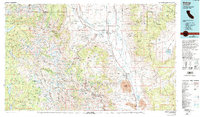
(7)- 1975 Map of Lone Pine NE, 1979 Print
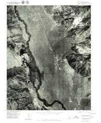 1975 Lone Pine NE1979 Print · USGSOwens Valley comes into sharp focus during the mid-seventies, showing the intersection of natural waterways and major infrastructure. Researchers can trace the layout of Manzanar, the course of the Owens River, and the path of the Los Angeles Aqueduct.
 - 1975 Map of Lone Pine SE, 1979 Print
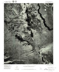 1975 Lone Pine SE1979 Print · USGSThe Owens Valley landscape and the settlement of Lone Pine are captured in this mid-seventies aerial survey. Researchers can trace the path of the Los Angeles Aqueduct and the stark expanse of the Owens Lake bed.2 unique versions available
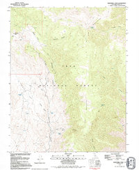
 - 1978 Map of Mount Whitney, 1992 Print
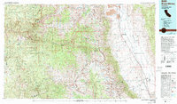 1978 Mount Whitney1992 Print · USGSThe high Sierra and Owens Valley meet in the late 1970s, showcasing the transition from alpine wilderness to valley floor settlements. Trace historical mining operations like the Green Monster Mine or find early routes to the summit near Whitney Portal.
 - 1978 Map of Isabella Lake, 1994 Print
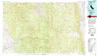
 1978 Isabella Lake1994 Print · USGSKern County's high country and the central reservoir system are detailed here during the late seventies. Researchers can trace historical sites like Havilah and Long Tom Mine, or explore the development around Isabella Lake and Wofford Heights.2 unique versions available
 - 1978 Map of Three Rivers, 1994 Print
 1978 Three Rivers1994 Print · USGSTulare County's dramatic ascent from the San Joaquin Valley to the High Sierra is captured here during the late seventies. Researchers can trace the layout of the Tule River Indian Reservation and locate early mountain outposts like Camp Nelson or Globe.2 unique versions available
 - 1978 Map of Bishop, 1994 Print
 1978 Bishop1994 Print · USGSThe Owens Valley and Eastern Sierra come alive in this late seventies study, documenting a landscape shaped by mining and high-altitude water storage. Local researchers can trace family names and industry at Pine Creek Mine, Scheelite, and Lucky Strike Mine.2 unique versions available
 - 1979 Map of Mazourka Peak, 1994 Print
 1979 Mazourka Peak1994 Print · USGSIn the Inyo Mountains during the late seventies, this survey captures a landscape of mineral exploration and high-desert water sources. Local historians can trace old mining claims at Mine or Mines and locate essential springs like Barrel Springs.
End of results
Showing maps 1-7 of 7
Top cities of Inyo County
- Bishop historical maps
- West Bishop historical maps
- Lone Pine historical maps
- Big Pine historical maps
- Independence historical maps
- Wilkerson historical maps
See more
Frequently asked questions
- What are the different types of historical maps available for Inyo County?
- What is the oldest map of Inyo County?
- Where can I purchase historical maps of Inyo County for my home or office?
- Where can I download high-res historical maps of Inyo County?
- Are there historical topographic maps available for Inyo County?
- Is there historical aerial imagery available for Inyo County?
- Where are historical maps of Inyo County sourced from?