1910s Maps of California City, California
Explore 4 historic maps of California City from the 1910s. These maps offer a rare glimpse into what life looked like during the 1910s — showing old roads, neighborhoods, homes, and landmarks that have changed or disappeared over time.
Whether you're researching your family's past, planning a metal detecting trip, or studying how California City's landscape evolved across the 1910s, these high-resolution maps are a powerful tool for exploring the history of this region.
- Focus on a specific era: All maps on this page are from the 1910s, giving you a focused view of this time period.
- See what’s changed: Compare century-old streets, trails, and buildings to today's modern landscape using overlays and satellite layers.
- Research with precision: Use these maps for genealogy, historical research, land use analysis, or educational projects.
- View, download, or print: Maps are fully viewable online in high resolution, and can be downloaded or printed for your own records.
Start exploring California City's history through authentic maps from the 1910s. This is your window into the past.
California City, CA maps
(4)- 1911 Map of Randsburg, 1958 Print
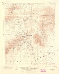 1911 Randsburg1958 Print · USGSHigh desert mining towns in Kern and San Bernardino counties flourished during this era of peak mineral extraction. Genealogists and historians can trace the early footprints of Randsburg and Johannesburg, or locate the Yellow Aster Mine and the rail-side settlement of Atolia.2 unique versions available
 - 1912 Map of Randsburg
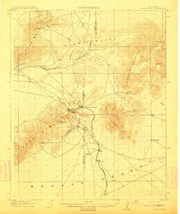 1912 Randsburg1912 Print · USGSThe Rand mining district comes to life in this early century survey of the Kern County desert. Trace the rail lines of the Southern Pacific and the footprint of the massive Yellow Aster Mine near Randsburg and Atolia.3 unique versions available
 - 1915 Map of Searles Lake
 1915 Searles Lake1915 Print · USGSThe Mojave Desert at the height of its early mining boom features a landscape defined by the Trona RR and the thriving gold camps of the Rand Mountains. Genealogists and historians can trace the foundations of Randsburg, the soda works at Trona, and remote outposts like Muerto Leliter PO and Garlock.6 unique versions available
 - 1915 Map of Mojave
 1915 Mojave1915 Print · USGSThe eastern Tehachapi Mountains meet the desert in the early twentieth century as a hub of rail and mining. Trace the historic paths of the Southern Pacific railroad through Tehachapi and Mojave, or locate remote sites like the Joe Walker Mine and Claraville.7 unique versions available
End of results
Showing maps 1-4 of 4
Top cities near California City
Frequently asked questions
- What are the different types of historical maps available for California City?
- What is the oldest map of California City?
- Where can I purchase historical maps of California City for my home or office?
- Where can I download high-res historical maps of California City?
- Are there historical topographic maps available for California City?
- Is there historical aerial imagery available for California City?
- Where are historical maps of California City sourced from?