1950s Maps of California City, California
Explore 7 historic maps of California City from the 1950s. These maps offer a rare glimpse into what life looked like during the 1950s — showing old roads, neighborhoods, homes, and landmarks that have changed or disappeared over time.
Whether you're researching your family's past, planning a metal detecting trip, or studying how California City's landscape evolved across the 1950s, these high-resolution maps are a powerful tool for exploring the history of this region.
- Focus on a specific era: All maps on this page are from the 1950s, giving you a focused view of this time period.
- See what’s changed: Compare century-old streets, trails, and buildings to today's modern landscape using overlays and satellite layers.
- Research with precision: Use these maps for genealogy, historical research, land use analysis, or educational projects.
- View, download, or print: Maps are fully viewable online in high resolution, and can be downloaded or printed for your own records.
Start exploring California City's history through authentic maps from the 1950s. This is your window into the past.
California City, CA maps
(7)- 1953 Map of Trona, 1956 Print
 1953 Trona1956 Print · USGSThe high desert of San Bernardino and Inyo counties during the early Cold War reveals a landscape of mineral industry and military expansion. You can trace the Old Spanish Trail, locate the Trona potash works, and find remote outposts like Ashford Mill.
 - 1954 Map of Boron, 1955 Print
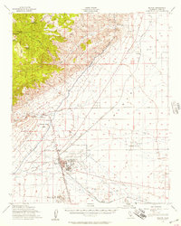
 1954 Boron1955 Print · USGSThe Mojave Desert's borax mining hub comes alive in the mid-1950s, showing the early development of the modern mining complex. Researchers can trace the industrial footprint of the Jennifer Mine, the community at Gephart School, and the remote Boron A F Station.3 unique versions available
 - 1955 Map of Bakersfield
 1955 Bakersfield1955 Print · USGSThe southern San Joaquin Valley in the mid-fifties shows an era of massive oil production and industrial irrigation. Trace family roots in Allensworth, the oil fields of Oildale, or the shorelines of Tulare Lake and Buena Vista Lake.
 - 1956 Map of Bakersfield
 1956 Bakersfield1956 Print · USGSThe southern San Joaquin Valley and High Sierra come alive in the mid-fifties, showing the region's complex agricultural and rail networks. Genealogists and historians can trace family roots in towns like Bakersfield, Taft, and Delano, or locate early infrastructure along the Sunset Railway.
 - 1956 Map of Castle Butte, 1957 Print
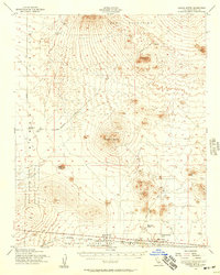 1956 Castle Butte1957 Print · USGSKern County’s High Desert was a focal point of military testing and ranching in the mid-fifties. Researchers can trace the early footprint of Edwards Air Force Base and find remote landmarks like Thundering Herd Ranch and Muroc Junction.3 unique versions available
 - 1956 Map of Mojave, 1957 Print
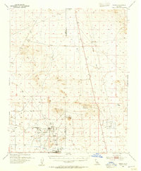
 1956 Mojave1957 Print · USGSThe high desert rail hub of Mojave comes alive in the mid-fifties as a vital intersection for the Southern Pacific and Santa Fe lines. Genealogists and historians can trace local life through the Marine Corps Auxiliary Air Station, the Los Angeles Aqueduct, and outposts like Reefer City and Neuralia.3 unique versions available
 - 1957 Map of Trona, 1964 Print
 1957 Trona1964 Print · USGSThe High Desert in the mid-fifties is captured here as a landscape of remote mining outposts and growing military installations. Trace the industrial rail lines to Trona, the mining history of Randsburg, or the isolated expanse of the Naval Ordnance Test Station.5 unique versions available
End of results
Showing maps 1-7 of 7
Top cities near California City
Frequently asked questions
- What are the different types of historical maps available for California City?
- What is the oldest map of California City?
- Where can I purchase historical maps of California City for my home or office?
- Where can I download high-res historical maps of California City?
- Are there historical topographic maps available for California City?
- Is there historical aerial imagery available for California City?
- Where are historical maps of California City sourced from?