1960s Maps of California City, California
Explore 6 historic maps of California City from the 1960s. These maps offer a rare glimpse into what life looked like during the 1960s — showing old roads, neighborhoods, homes, and landmarks that have changed or disappeared over time.
Whether you're researching your family's past, planning a metal detecting trip, or studying how California City's landscape evolved across the 1960s, these high-resolution maps are a powerful tool for exploring the history of this region.
- Focus on a specific era: All maps on this page are from the 1960s, giving you a focused view of this time period.
- See what’s changed: Compare century-old streets, trails, and buildings to today's modern landscape using overlays and satellite layers.
- Research with precision: Use these maps for genealogy, historical research, land use analysis, or educational projects.
- View, download, or print: Maps are fully viewable online in high resolution, and can be downloaded or printed for your own records.
Start exploring California City's history through authentic maps from the 1960s. This is your window into the past.
California City, CA maps
(6)- 1960 Map of Trona
 1960 Trona1960 Print · USGSThe Mojave Desert at mid-century reveals a landscape of massive military installations and industrial mineral works. Researchers can trace the heritage of mining and ranching at Ashford Mill, Randsburg, and Paxton Ranch while following the Old Spanish Trail.2 unique versions available
 - 1960 Map of Bakersfield
 1960 Bakersfield1960 Print · USGSThe Southern San Joaquin Valley at mid-century reveals a complex landscape of petroleum development and massive irrigation projects. Researchers can trace the rail lines of the Southern Pacific, explore oil-era landmarks like Oil City, and locate early settlements including Allensworth and Pixley.2 unique versions available
 - 1962 Map of Bakersfield, 1969 Print
 1962 Bakersfield1969 Print · USGSThe Southern San Joaquin Valley is shown in the 1960s as a bustling intersection of petroleum production, irrigation agriculture, and mountain recreation. Researchers can trace the rail lines of the Southern Pacific through the valley or locate early desert developments like California City and Tehachapi.4 unique versions available
 - 1966 Map of Bakersfield
 1966 Bakersfield1966 Print · USGSThe southern San Joaquin Valley in the mid-sixties reveals a massive industrial and agricultural landscape shaped by water and oil. Genealogists and historians can trace the growth of Bakersfield and Oildale, or locate remote airfields like Minter Field and Mojave-Kern County No. 7 Airport.
 - 1967 Map of Saltdale SE, 1968 Print
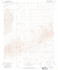 1967 Saltdale SE1968 Print · USGSKern County's high desert landscape comes into focus during the late 1960s as residential planning began to edge into the wilderness. Trace early development along the California City boundary or follow historic desert routes like Mojave Road and the Southern Pacific line.2 unique versions available
 - 1967 Map of Johannesburg, 1968 Print
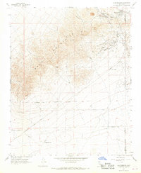 1967 Johannesburg1968 Print · USGSThe mining camps of the Rand Mountains are captured in the late sixties, showing the enduring footprint of the Yellow Aster Mine. Researchers can trace the early layout of California City and the historic streets of Randsburg and Johannesburg near Fiddler Gulch.2 unique versions available
End of results
Showing maps 1-6 of 6
Top cities near California City
Frequently asked questions
- What are the different types of historical maps available for California City?
- What is the oldest map of California City?
- Where can I purchase historical maps of California City for my home or office?
- Where can I download high-res historical maps of California City?
- Are there historical topographic maps available for California City?
- Is there historical aerial imagery available for California City?
- Where are historical maps of California City sourced from?