1970s Maps of California City, California
Explore 9 historic maps of California City from the 1970s. These maps offer a rare glimpse into what life looked like during the 1970s — showing old roads, neighborhoods, homes, and landmarks that have changed or disappeared over time.
Whether you're researching your family's past, planning a metal detecting trip, or studying how California City's landscape evolved across the 1970s, these high-resolution maps are a powerful tool for exploring the history of this region.
- Focus on a specific era: All maps on this page are from the 1970s, giving you a focused view of this time period.
- See what’s changed: Compare century-old streets, trails, and buildings to today's modern landscape using overlays and satellite layers.
- Research with precision: Use these maps for genealogy, historical research, land use analysis, or educational projects.
- View, download, or print: Maps are fully viewable online in high resolution, and can be downloaded or printed for your own records.
Start exploring California City's history through authentic maps from the 1970s. This is your window into the past.
California City, CA maps
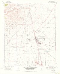
(9)- 1973 Map of California City North, 1976 Print
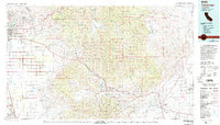
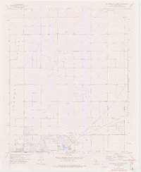 1973 California City North1976 Print · USGSThe mid-1970s expansion of California City is captured here as a grid of desert boulevards meets the rising Rand Mountains. Trace the early development of this planned community through landmarks like Central Park and its extensive network of surveyed streets like Hacienda Blvd.2 unique versions available
 - 1973 Map of Galileo Hill, 1976 Print
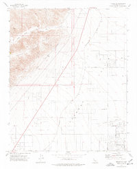
 1973 Galileo Hill1976 Print · USGSCalifornia City in the early 1970s shows the expansive, geometric grid of a master-planned community taking shape in the desert. Trace the extensive network of planned boulevards and local landmarks like Galileo Hill, Galileo Park, and the historic Twenty Mule Team Road.
 - 1973 Map of Boron NW, 1976 Print
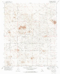
 1973 Boron NW1976 Print · USGSKern County desert landscapes in the early seventies reveal the expansive planned grid of California City. Researchers can trace early street layouts like Twenty Mule Team Parkway or locate local landmarks including Castle Butte and various mineral Prospects.2 unique versions available
 - 1973 Map of Sanborn, 1976 Print
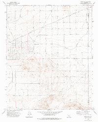
 1973 Sanborn1976 Print · USGSThe Fremont Valley in the early 1970s shows a desert landscape shaped by resource extraction and rail transport. Researchers can trace the Southern Pacific rail line and locate early features like Sanborn Hill, Cache Creek, and the gravel pit.3 unique versions available
 - 1973 Map of Mojave, 1976 Print
 1973 Mojave1976 Print · USGSMojave sits at the crossroads of major rail and aviation lines in the 1970s, serving as a vital desert transportation hub. Researchers can trace the path of the Los Angeles Aqueduct and locate local landmarks like the Joshua Sch and Standard Hill.2 unique versions available
 - 1973 Map of California City South, 1976 Print
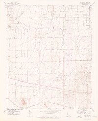
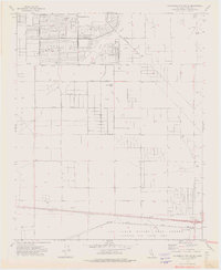 1973 California City South1976 Print · USGSThe ambitious desert development of California City and the northern reaches of Edwards Air Force Base are captured here in the early 1970s. Researchers can trace the vast grid of planned streets and find localized landmarks like Ulrich Sch, Edwards Siding, and the rail lines of the Atchison Topeka and Santa Fe.2 unique versions available
 - 1973 Map of Mojave NE, 1977 Print
 1973 Mojave NE1977 Print · USGSThe Mojave Desert during the early 1970s reveals a unique moment of planned urban growth and traditional industry. Trace the extensive street grid of California City alongside the vital Los Angeles Aqueduct and Southern Pacific rail line.4 unique versions available
 - 1976 Map of Cuddeback Lake, 1993 Print
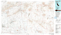 1976 Cuddeback Lake1993 Print · USGSThe western Mojave Desert comes into focus in the mid-seventies, showing the intersection of historic mining districts and modern aerospace facilities. You can trace the workings of the Yellow Aster Mine, the streets of California City, and the path of the Los Angeles Aqueduct.
 - 1978 Map of Tehachapi, 1993 Print
 1978 Tehachapi1993 Print · USGSThe Kern County landscape in the late seventies reveals the transition from valley agriculture to high mountain passes. Trace the rail lines of the Southern Pacific and explore early settlements like Weed Patch, Loraine, and Edmundson Acres.
End of results
Showing maps 1-9 of 9
Top cities near California City
Frequently asked questions
- What are the different types of historical maps available for California City?
- What is the oldest map of California City?
- Where can I purchase historical maps of California City for my home or office?
- Where can I download high-res historical maps of California City?
- Are there historical topographic maps available for California City?
- Is there historical aerial imagery available for California City?
- Where are historical maps of California City sourced from?