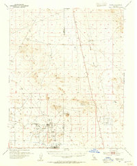
1954 Map of Boron
USGS Topo · Published 1955About this map
The industrial and military landscape of the Mojave Desert is captured here during the mid-1950s, centered on the borax mining operations at Baker (Boron P O) and the adjacent Boron townsite. The extraction infrastructure is prominent, featuring the Jennifer Mine, extensive Tailings, and a large Tailings Pond that reflect the area's role as a global center for mineral production. Transportation networks are vital to this desert economy, with the A T & S F railroad and a nearby Landing Field serving the isolated community.
Find a feature on this map
26 named features on this map. Tap any name to fly to it.
Don’t see what you’re looking for? This feature index may not catch every label — zoom into the map to look around manually.
Map Details
Editions of this 1954 Boron Map
3 editions found
Other maps of this area

1903 · Randsburg
USGS Topo · 1:62,500

1911 · Randsburg
USGS Topo · 1:62,500

1912 · Randsburg
USGS Topo · 1:62,500

1915 · Searles Lake
USGS Topo · 1:250,000

1932 · Barstow
USGS Topo · 1:125,000

1934 · Barstow
USGS Topo · 1:125,000

1937 · Kramer
USGS Topo · 1:48,000

1937 · Rogers Lake
USGS Topo · 1:48,000

1942 · Kramer
USGS Topo · 1:62,500

1942 · Rogers Lake
USGS Topo · 1:62,500