2020s Maps of Marin County, California
Explore 22 historic maps of Marin County from the 2020s. These maps offer a rare glimpse into what life looked like during the 2020s — showing old roads, neighborhoods, homes, and landmarks that have changed or disappeared over time.
Whether you're researching your family's past, planning a metal detecting trip, or studying how Marin County's landscape evolved across the 2020s, these high-resolution maps are a powerful tool for exploring the history of this region.
- Focus on a specific era: All maps on this page are from the 2020s, giving you a focused view of this time period.
- See what’s changed: Compare century-old streets, trails, and buildings to today's modern landscape using overlays and satellite layers.
- Research with precision: Use these maps for genealogy, historical research, land use analysis, or educational projects.
- View, download, or print: Maps are fully viewable online in high resolution, and can be downloaded or printed for your own records.
Start exploring Marin County's history through authentic maps from the 2020s. This is your window into the past.
Marin County, CA maps
(22)- 2021 Map of Bolinas, 2021 Print
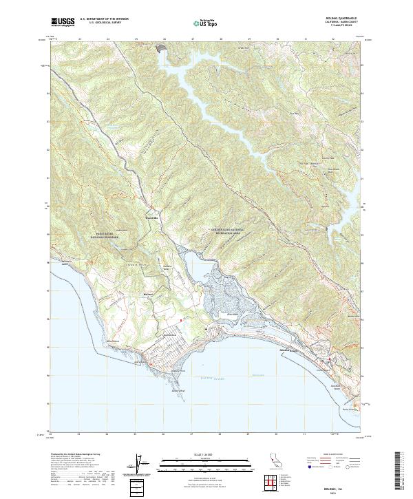 2021 Bolinas2021 Print · USGSThe Marin County coast is documented here in the early twenty-first century, showing the delicate interface of the Bolinas Lagoon and the surrounding heights. Researchers can trace local landmarks from Stinson Beach to Woodville, alongside features like Cataract Falls and Kent Island.
 - 2021 Map of Drakes Bay OE W, 2021 Print
 2021 Drakes Bay OE W2021 Print · USGSCoastal Marin County meets the Pacific in the early 2020s, showing the intersection of maritime expanse and protected shoreline. You can trace the Point Reyes Beach Route Trl along the edge of the Point Reyes National Seashore.
 - 2021 Map of Double Point, 2021 Print
 2021 Double Point2021 Print · USGSThe Marin County coastline comes into sharp focus during the early twenty-first century, showcasing the preserved wilderness of the Point Reyes National Seashore. Researchers can trace intricate trail networks and coastal features like Alamere Falls, Stormy Stack, and Wildcat Lake.
 - 2021 Map of Bodega Head, 2021 Print
 2021 Bodega Head2021 Print · USGSCoastal Sonoma County is captured here in the early 2020s, showing the intersection of maritime life and preserved shoreline. You can trace local landmarks like Bodega Bay Cem and the small settlements of Salmon Creek and Swallow City.
 - 2021 Map of Drakes Bay OE SW, 2021 Print
 2021 Drakes Bay OE SW2021 Print · USGSThe Marin County coast at the western edge of the peninsula is captured here in the early 2020s. Hikers and maritime historians can trace the paths along Point Reyes including the Point Reyes Lighthouse Trl and the secluded Sea Lion Cove.
 - 2021 Map of Petaluma River, 2021 Print
 2021 Petaluma River2021 Print · USGSThe Petaluma River valley and its intricate marshlands are captured in this recent survey of the North Bay. Researchers can trace the boundaries of SONOMA CO and MARIN CO while locating landmarks like Gnoss Field, Burdell Mtn, and the riverfront at Lakeville.
 - 2021 Map of Valley Ford, 2021 Print
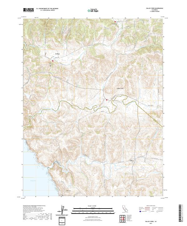 2021 Valley Ford2021 Print · USGSCoastal Sonoma and Marin counties are captured here in the early 2020s, where tidal estuaries meet historic ranching lands. Genealogists and locals can trace family sites near Bodega Calvary Cemetery and the settlements of Bodega and Fallon.
 - 2021 Map of Two Rock, 2021 Print
 2021 Two Rock2021 Print · USGSCoastal hills and agricultural valleys define this portion of Sonoma and Marin counties as they appeared in recent years. Researchers can trace rural lineages through sites like the Two Rock Presbyterian Church Cem, Bloomfield, and the scattered crossroads of Knowles Corner and Cadwell.
 - 2021 Map of San Geronimo, 2021 Print
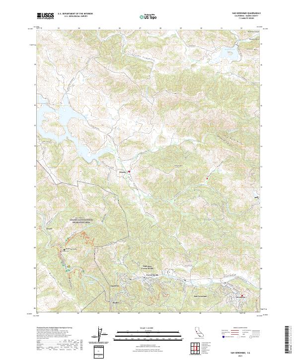 2021 San Geronimo2021 Print · USGSThe San Geronimo Valley and Nicasio ranchlands are documented here in the early twenty-first century as they maintain their rural character. Researchers can find precise locations for Taylor Cem, the small settlement of Jewell, and the peaks of Big Rock Ridge.
 - 2021 Map of Novato, 2021 Print
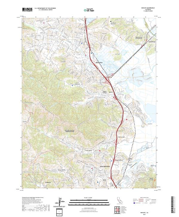 2021 Novato2021 Print · USGSMarin County's northern corridor comes into focus in the early 2020s, showcasing the suburban expansion between the bay marshes and the ridges. Genealogists and locals can trace family sites at Valley Memorial Park or explore the route of the Old Railroad Grade near Novato.
 - 2021 Map of Petaluma, 2021 Print
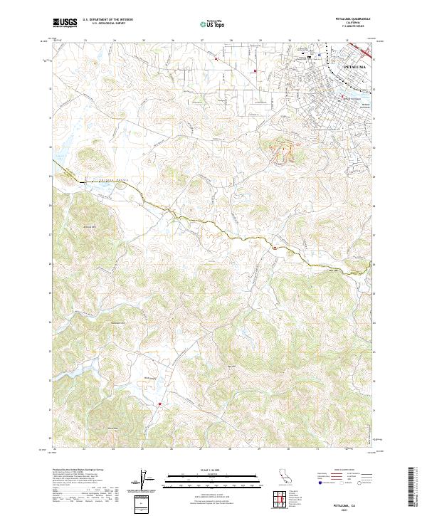 2021 Petaluma2021 Print · USGSThe city of Petaluma meets the rural valleys of Sonoma and Marin counties in this recent study. Researchers can trace urban growth near the Petaluma River or locate family plots at Bnai Israel Cem and Cypress Hill Memorial Park.
 - 2021 Map of Drakes Bay, 2021 Print
 2021 Drakes Bay2021 Print · USGSThe Marin coastline is shown in comprehensive detail during the early 2020s, highlighting the protected environments of the Pacific edge. Researchers can trace the extensive trail system and coastal landmarks such as Limantour Spit, Abbotts Lagoon, and the US Coast Guard Cemetery Rd.
 - 2021 Map of San Rafael, 2021 Print
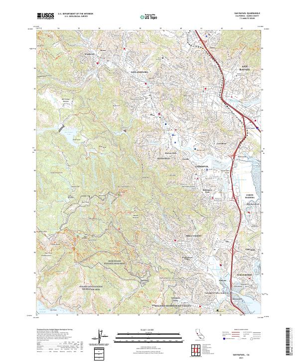 2021 San Rafael2021 Print · USGSMarin County's ridges and bayside towns are shown here in the modern era, from the redwood groves to the waterfront. Trace local landmarks like the College of Marin, the Municipal Yacht Harbor, and Muir Woods National Monument.
 - 2021 Map of San Quentin, 2021 Print
 2021 San Quentin2021 Print · USGSThe Marin and Contra Costa shorelines meet at the San Pablo Strait in this contemporary survey of the northern Bay Area. Researchers can trace the waterfront from San Quentin down to the Tiburon Peninsula, or examine East Bay landmarks like Point Richmond and Brooks Island.
 - 2021 Map of Mare Island, 2021 Print
 2021 Mare Island2021 Print · USGSThe northern reaches of San Francisco Bay appear in high detail during the early 2020s, showing the dense urban and industrial development of the East Bay. Trace local history through the streets of Vallejo, the naval heritage of Mare Island, and family markers at Hillside Cem.
 - 2021 Map of Point Reyes NE, 2021 Print
 2021 Point Reyes NE2021 Print · USGSCoastal Marin County ranch lands and protected wilderness areas are captured in this modern survey of the hills above Tomales Bay. Researchers can trace the complex drainage networks of Walker Cr and locate the sprawling Soulajule Reservoir near the Sonoma County line.
 - 2021 Map of San Francisco North, 2021 Print
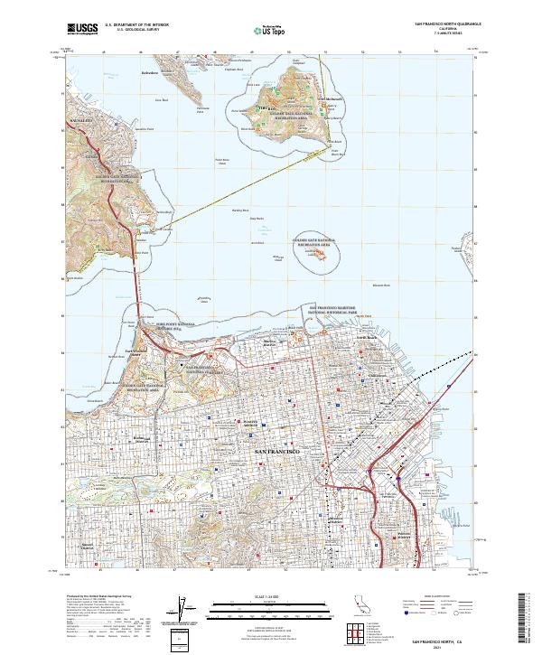 2021 San Francisco North2021 Print · USGSSan Francisco and the Golden Gate are captured here in the early twenty-first century, from the dense grid of Chinatown to the heights of SAUSALITO. Trace local roots through sites like St Marys Cathedral, the National Cemetery, and Alcatraz Island.
 - 2021 Map of Point Bonita, 2021 Print
 2021 Point Bonita2021 Print · USGSThe Marin Headlands and the entrance to the bay are captured here in the early 2020s, showcasing the intersection of urban development and vast coastal preserves. Researchers can trace the extensive trail systems of the GGNRA, find local landmarks like Point Bonita, and explore the topography of Sausalito.
 - 2021 Map of Drakes Bay OE S, 2021 Print
 2021 Drakes Bay OE S2021 Print · USGSMarin County's dramatic coastal edge is captured here in the early twenty-first century, centered on the protected lands of the peninsula. Local history enthusiasts can trace the paths of Lighthouse Rd and the Chimney Rock Trl out to the lookout at Chimney Rock.
 - 2022 Map of Inverness, 2022 Print
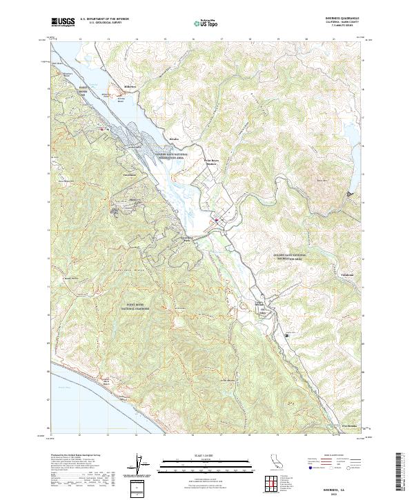 2022 Inverness2022 Print · USGSThe Marin County coastline near Inverness and Tomales Bay is captured here in the twenty-first century. Researchers can trace the rugged topography from Mt Wittenberg to historic sites like the Olema Cem and Point Reyes Station.
 - 2022 Map of Petaluma Point, 2022 Print
 2022 Petaluma Point2022 Print · USGSSan Pablo Bay and the Marin coastline are captured here in the early 2020s, showing the meeting of four major North Bay counties. Researchers can trace the unique shoreline topography of China Camp Point, the marshes of Tubbs Island, and hills like Turtle Back.
 - 2022 Map of Tomales, 2022 Print
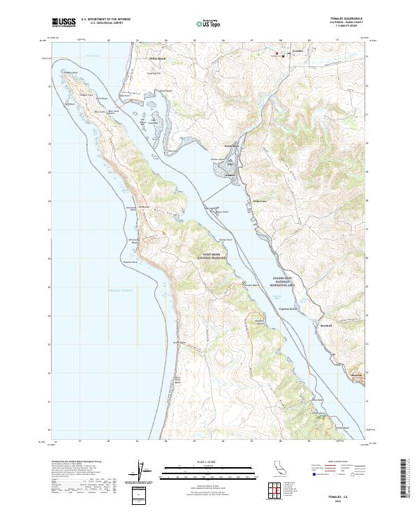 2022 Tomales2022 Print · USGSMarin County's coastal edge is documented here in the early twenty-first century as it balances historic settlements and protected parklands. Researchers can trace the family names and locations of Tomales, Marshall, and the Tomales Cem along the eastern shore.
End of results
Showing maps 1-22 of 22
Top cities of Marin County
- San Rafael historical maps
- Novato historical maps
- Mill Valley historical maps
- San Anselmo historical maps
- Larkspur historical maps
- Corte Madera historical maps
See more
Frequently asked questions
- What are the different types of historical maps available for Marin County?
- What is the oldest map of Marin County?
- Where can I purchase historical maps of Marin County for my home or office?
- Where can I download high-res historical maps of Marin County?
- Are there historical topographic maps available for Marin County?
- Is there historical aerial imagery available for Marin County?
- Where are historical maps of Marin County sourced from?