1990s Maps of Marin County, California
Explore 14 historic maps of Marin County from the 1990s. These maps offer a rare glimpse into what life looked like during the 1990s — showing old roads, neighborhoods, homes, and landmarks that have changed or disappeared over time.
Whether you're researching your family's past, planning a metal detecting trip, or studying how Marin County's landscape evolved across the 1990s, these high-resolution maps are a powerful tool for exploring the history of this region.
- Focus on a specific era: All maps on this page are from the 1990s, giving you a focused view of this time period.
- See what’s changed: Compare century-old streets, trails, and buildings to today's modern landscape using overlays and satellite layers.
- Research with precision: Use these maps for genealogy, historical research, land use analysis, or educational projects.
- View, download, or print: Maps are fully viewable online in high resolution, and can be downloaded or printed for your own records.
Start exploring Marin County's history through authentic maps from the 1990s. This is your window into the past.
Marin County, CA maps
(14)- 1993 Map of Farallon Islands
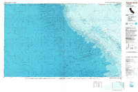 1993 Farallon Islands1993 Print · USGSThe Pacific shelf edge and its isolated outcroppings come into focus in the early 1990s. Researchers can trace the rugged perimeter of the Farallon National Wildlife Refuge and locate hazards like Noonday Rock and Fanny Shoal.
 - 1993 Map of San Francisco North, 1997 Print
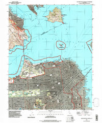 1993 San Francisco North1997 Print · USGSSan Francisco and the Golden Gate are captured here during the early nineties, showing the city's dense neighborhoods and military grounds. Trace the historic streets of Chinatown, the docks at Fishermans Wharf, and the grounds of the Presidio.
 - 1993 Map of Double Point, 1997 Print
 1993 Double Point1997 Print · USGSThe Point Reyes peninsula in the early 1990s shows a landscape of protected coastal wilderness and striking geology. Researchers can trace the Coast Trail past Alamere Falls, Wildcat Lake, and the distinctive Stormy Stack on the shoreline.
 - 1993 Map of Bolinas, 1997 Print
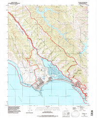 1993 Bolinas1997 Print · USGSCoastal Marin County comes into focus in the 1990s as the wilderness of the Point Reyes National Seashore meets the shifting tides of Bolinas Lagoon. Researchers can trace local landmarks like Peters Dam, the McKinnan Gulch Mine, and the Hill 640 Military Res at the shoreline.
 - 1993 Map of San Quentin, 1997 Print
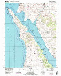
 1993 San Quentin1997 Print · USGSThe northern San Francisco Bay shoreline in the early nineties reveals a blend of heavy industry and coastal conservation. Researchers can trace the footprints of San Quentin State Prison, the Naval Fuel Supply Depot, and maritime landmarks like the Lighthouse at Point San Pablo.
 - 1993 Map of San Rafael, 1997 Print
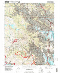
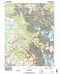 1993 San Rafael1997 Print · USGSMarin County's valleys and ridges are captured in the early nineties as residential growth meets protected redwood groves and marshes. Trace the suburban evolution of Mill Valley and San Rafael alongside preserved sites like Muir Woods National Monument.
 - 1993 Map of Point Bonita, 1997 Print
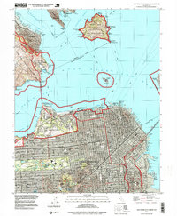
 1993 Point Bonita1997 Print · USGSThe entrance to San Francisco Bay is captured in the early nineties, showing the interface of urban growth and protected coastal lands. Trace the shoreline from Muir Beach down to Lands End and the street grids of San Francisco near Ft Miley.
 - 1994 Map of Double Point, 1999 Print
 1994 Double Point1999 Print · USGSThe Marin County coast is captured here in the mid-nineties, showing the wild interface of the Point Reyes National Seashore and the Pacific Ocean. Researchers can trace historic paths like the Coast Trail past Wildcat Lake and the dramatic Alamere Falls.
 - 1995 Map of Point Reyes NE, 1998 Print
 1995 Point Reyes NE1998 Print · USGSNorthwestern Marin and southern Sonoma counties are shown in the mid-nineties, capturing a landscape of historic land grants and coastal hills. Researchers can trace the divisions of Nicasio (Halleck) and Soulajule (Brackett) near Tomales Bay.
 - 1995 Map of Tomales, 1998 Print
 1995 Tomales1998 Print · USGSThe Marin County coast is documented here in the late twentieth century, showing a landscape defined by the San Andreas Rift Zone. Researchers can trace old family ranching legacies at Lower Pierce Ranch or explore the waterfront history of Marshall and Lairds Landing.
 - 1995 Map of San Rafael, 1999 Print
 1995 San Rafael1999 Print · USGSMarin County at the end of the century shows a unique balance of dense suburban development and sprawling protected peaks. Genealogists and researchers can trace local landmarks like Mt Tamalpais Cemetery, the College of Marin, and Silva Island.
 - 1995 Map of San Francisco North, 1999 Print
 1995 San Francisco North1999 Print · USGSSan Francisco's northern peninsula is captured in the mid-nineties, showing the dense urban grid from the Mission District to the Presidio of San Francisco. Researchers can trace neighborhood landmarks such as Mission Dolores, the Fishermans Wharf waterfront, and the historic grounds of Fort Scott.
 - 1995 Map of San Quentin, 1999 Print
 1995 San Quentin1999 Print · USGSThe San Francisco Bay area in the mid-nineties shows a mix of industrial giants and protected shorelines. Trace the piers of the Long Wharf, the grounds of San Quentin State Prison, and the hills of China Camp State Park.
 - 1995 Map of Drakes Bay, 2000 Print
 1995 Drakes Bay2000 Print · USGSThe Marin County coastline at the turn of the millennium remains a mix of rugged shore and historical dairy ranches. Genealogists and historians can trace family-named lands like S D Ranch and Home Ranch or locate the historic Lighthouse and Schooner Ldg (Site).
End of results
Showing maps 1-14 of 14
Top cities of Marin County
- San Rafael historical maps
- Novato historical maps
- Mill Valley historical maps
- San Anselmo historical maps
- Larkspur historical maps
- Corte Madera historical maps
See more
Frequently asked questions
- What are the different types of historical maps available for Marin County?
- What is the oldest map of Marin County?
- Where can I purchase historical maps of Marin County for my home or office?
- Where can I download high-res historical maps of Marin County?
- Are there historical topographic maps available for Marin County?
- Is there historical aerial imagery available for Marin County?
- Where are historical maps of Marin County sourced from?