1950s Maps of Modoc County, California
Explore 8 historic maps of Modoc County from the 1950s. These maps offer a rare glimpse into what life looked like during the 1950s — showing old roads, neighborhoods, homes, and landmarks that have changed or disappeared over time.
Whether you're researching your family's past, planning a metal detecting trip, or studying how Modoc County's landscape evolved across the 1950s, these high-resolution maps are a powerful tool for exploring the history of this region.
- Focus on a specific era: All maps on this page are from the 1950s, giving you a focused view of this time period.
- See what’s changed: Compare century-old streets, trails, and buildings to today's modern landscape using overlays and satellite layers.
- Research with precision: Use these maps for genealogy, historical research, land use analysis, or educational projects.
- View, download, or print: Maps are fully viewable online in high resolution, and can be downloaded or printed for your own records.
Start exploring Modoc County's history through authentic maps from the 1950s. This is your window into the past.
Modoc County, CA maps
(8)- 1951 Map of Clear Lake Reservoir, 1952 Print
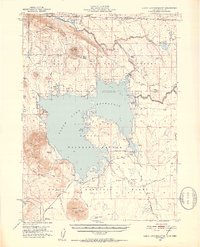 1951 Clear Lake Reservoir1952 Print · USGSModoc County's high-desert basins and water systems are captured in the early fifties, just as the wildlife refuge and reservoir reached their modern configuration. Researchers can trace the historic Emigrant Trail or locate legacy ranching sites like McNeil Ranch and Chandler Ranch.5 unique versions available
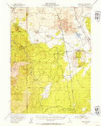
 - 1951 Map of Tulelake, 1953 Print
 1951 Tulelake1953 Print · USGSTule Lake and the Modoc plateau are captured in the early fifties during the height of the region's agricultural development. Genealogists and historians can trace the legacy of family ranching at Old Elliot Ranch or locate the historic Battle of Lands Ranch (Site) and Carr School.4 unique versions available
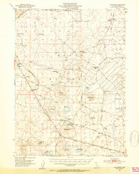
 - 1952 Map of Timber Mountain, 1954 Print
 1952 Timber Mountain1954 Print · USGSThe Modoc high country in the early fifties shows a rugged landscape of volcanic flows and forest industry. You can trace the Modoc War history at Captain Jacks Stronghold or locate logging era sites like Old Camp One and the Tionesta PO.5 unique versions available
 - 1952 Map of Hackamore, 1954 Print
 1952 Hackamore1954 Print · USGSHigh desert timberlands and volcanic peaks define the Modoc National Forest in the early fifties as the railroad connected remote outposts. Trace the rail-and-resource economy through Meares, the Pumice Brick Plant, and the complex of Hackamore Reservoir.4 unique versions available
 - 1954 Map of Vya, 1967 Print
 1954 Vya1967 Print · USGSThe tri-state corner of Nevada, Oregon, and California appears here in the mid-fifties, dominated by wildlife refuges and massive naval gunnery ranges. Trace isolated high-desert outposts like Vya and Soldier Meadow Ranch or find historic workings at the Ashdown Mine.3 unique versions available
 - 1954 Map of Alturas, 1968 Print
 1954 Alturas1968 Print · USGSThe Modoc Plateau and Surprise Valley appear in the mid-1950s as a landscape of remote ranching towns and vast wildlife refuges. Researchers can trace early settlements like Fort Bidwell, locate the McArthur Grain Elevator, and follow the Southern Pacific rail lines.4 unique versions available
 - 1958 Map of Alturas
 1958 Alturas1958 Print · USGSThe Modoc Plateau and Warner Mountains appear here during the late fifties, showcasing a landscape of high-desert ranching and volcanic terrain. Researchers can trace the rail-and-water economy through Alturas, Cedarville, and the Fort Bidwell Indian Res.2 unique versions available
 - 1958 Map of Vya
 1958 Vya1958 Print · USGSNorthwest Nevada and the tri-state border region are mapped here during the mid-fifties, showing a remote landscape of high desert ranches and sprawling antelope range. Trace historic operations like the Ashdown Mine, find local camps like Coyote Camp, and locate isolated outposts from Vya to Denio.2 unique versions available
End of results
Showing maps 1-8 of 8
Top cities of Modoc County
- Alturas historical maps
- Cedarville historical maps
- Adin historical maps
- Fort Bidwell historical maps
- Eagleville historical maps
Frequently asked questions
- What are the different types of historical maps available for Modoc County?
- What is the oldest map of Modoc County?
- Where can I purchase historical maps of Modoc County for my home or office?
- Where can I download high-res historical maps of Modoc County?
- Are there historical topographic maps available for Modoc County?
- Is there historical aerial imagery available for Modoc County?
- Where are historical maps of Modoc County sourced from?