1970s Maps of Modoc County, California
Explore 2 historic maps of Modoc County from the 1970s. These maps offer a rare glimpse into what life looked like during the 1970s — showing old roads, neighborhoods, homes, and landmarks that have changed or disappeared over time.
Whether you're researching your family's past, planning a metal detecting trip, or studying how Modoc County's landscape evolved across the 1970s, these high-resolution maps are a powerful tool for exploring the history of this region.
- Focus on a specific era: All maps on this page are from the 1970s, giving you a focused view of this time period.
- See what’s changed: Compare century-old streets, trails, and buildings to today's modern landscape using overlays and satellite layers.
- Research with precision: Use these maps for genealogy, historical research, land use analysis, or educational projects.
- View, download, or print: Maps are fully viewable online in high resolution, and can be downloaded or printed for your own records.
Start exploring Modoc County's history through authentic maps from the 1970s. This is your window into the past.
Modoc County, CA maps
(2)- 1975 Map of Alturas NE, 1978 Print
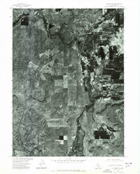 1975 Alturas NE1978 Print · USGSThe Modoc plateau landscape comes into sharp focus in the mid-1970s at the meeting of the forks of the Pit River. Researchers can trace the development of Alturas and the nearby settlement of Paola against the surrounding agricultural patchwork.
 - 1979 Map of Hays Canyon, 1980 Print
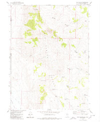 1979 Hays Canyon1980 Print · USGSWashoe County's high-desert borderland is captured here in the late seventies, showing the vital spring-and-trail networks of the basin and range. Researchers can trace remote water sources like Pick And Shovel Springs No 1 and sites like Indian Pole Camp.
End of results
Showing maps 1-2 of 2
Top cities of Modoc County
- Alturas historical maps
- Cedarville historical maps
- Adin historical maps
- Fort Bidwell historical maps
- Eagleville historical maps
Frequently asked questions
- What are the different types of historical maps available for Modoc County?
- What is the oldest map of Modoc County?
- Where can I purchase historical maps of Modoc County for my home or office?
- Where can I download high-res historical maps of Modoc County?
- Are there historical topographic maps available for Modoc County?
- Is there historical aerial imagery available for Modoc County?
- Where are historical maps of Modoc County sourced from?