1940s Maps of San Diego, California
Explore 20 historic maps of San Diego from the 1940s. These maps offer a rare glimpse into what life looked like during the 1940s — showing old roads, neighborhoods, homes, and landmarks that have changed or disappeared over time.
Whether you're researching your family's past, planning a metal detecting trip, or studying how San Diego's landscape evolved across the 1940s, these high-resolution maps are a powerful tool for exploring the history of this region.
- Focus on a specific era: All maps on this page are from the 1940s, giving you a focused view of this time period.
- See what’s changed: Compare century-old streets, trails, and buildings to today's modern landscape using overlays and satellite layers.
- Research with precision: Use these maps for genealogy, historical research, land use analysis, or educational projects.
- View, download, or print: Maps are fully viewable online in high resolution, and can be downloaded or printed for your own records.
Start exploring San Diego's history through authentic maps from the 1940s. This is your window into the past.
San Diego, CA maps
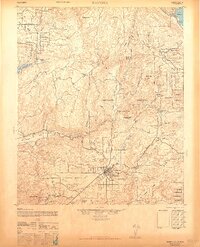
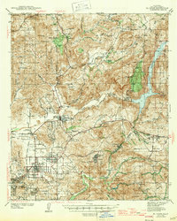
(20)- 1942 Map of Poway Valley
 1942 Poway Valley1942 Print · USGSCoastal San Diego's interior valleys and ranch lands are shown in the early 1940s as rural communities began to coalesce. Genealogists and researchers can trace the early layout of Poway, the site of Pomerado Sch, and the Emergency Landing Field at Scripps Ranch.2 unique versions available
 - 1942 Map of La Mesa
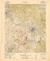
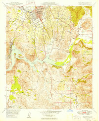
 1942 La Mesa1942 Print · USGSSan Diego and La Mesa appear here in the early 1940s, showing a landscape of growing residential neighborhoods and rugged canyon terrain. Genealogists and historians can trace numerous early schools like Hoover High Sch, the grounds of State College, and the historic Mission San Diego.
 - 1942 Map of Escondido
 1942 Escondido1942 Print · USGSNorthern San Diego County is captured here in the early 1940s, showing the inland citrus and ranching valleys before major development. Researchers can locate early schoolhouses like Rincon Sch and trace the original Escondido Branch rail line.
 - 1942 Map of Point Loma
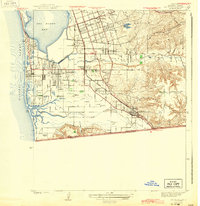
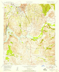
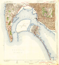 1942 Point Loma1942 Print · USGSSan Diego and the peninsula appear here in the early 1940s, showcasing a landscape of naval installations and coastal neighborhoods. Trace family roots and local history through Roseville Point Loma PO, Tent City, and the Union Sta rail hub.2 unique versions available
 - 1942 Map of El Cajon
 1942 El Cajon1942 Print · USGSInland San Diego County unfolds in the early 1940s, showing a landscape of working ranches and river valleys before modern development. Genealogists and historians can trace family-named lands like Peale Ranch and early institutions such as Dehesa Sch and the Daky Mine.
 - 1942 Map of Ramona, 1947 Print
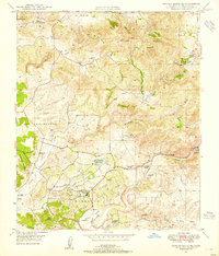
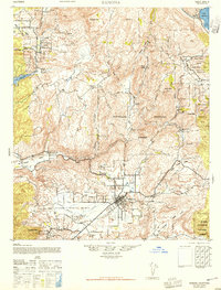 1942 Ramona1947 Print · USGSNorthern San Diego County ranching and forest lands are detailed here during the mid-1940s. Local researchers can trace family-named sites like Silvano Ranch or explore the boundaries of the San Pasqual Indian Reservation and Mesa Grande.2 unique versions available
 - 1943 Map of Del Mar
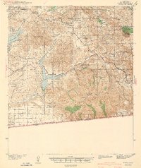
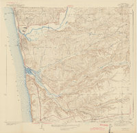 1943 Del Mar1943 Print · USGSCoastal San Diego County was a mix of quiet seaside towns and rugged inland ranching during the early 1940s. Genealogists and historians can trace old homesteads and landmarks like the Penasquitos Ranch, Soledad Sch, and the Mercy Hospital Farm.2 unique versions available
 - 1943 Map of La Jolla
 1943 La Jolla1943 Print · USGSSan Diego's coastline and inland mesas are captured here during the early 1940s, showing the early footprints of coastal neighborhoods. Researchers can trace historic landmarks like Scripps Institute of Oceanography, Crystal Pier, and the Brown Military Academy.2 unique versions available
 - 1943 Map of San Ysidro
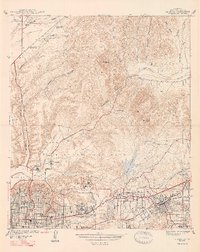
 1943 San Ysidro1943 Print · USGSThe Southern California borderlands during the early 1940s reveal a mix of coastal defense, salt harvesting, and emerging towns. Researchers can trace the rail lines through San Ysidro Station or locate family landmarks like Howard Ranch and Emory Sch.2 unique versions available
 - 1943 Map of Jamul
 1943 Jamul1943 Print · USGSSouthern San Diego County ranching and water history is captured here at the start of the 1940s. Genealogists and local historians can trace family holdings like Ivanhoe Ranch and Otay Ranch alongside community landmarks such as Dulzura Sch and the Camp Minnewawa CCC camp.
 - 1944 Map of National City
 1944 National City1944 Print · USGSPost-war San Diego County comes alive in this survey of the South Bay and its inland valleys. Genealogists and historians can trace family plots at Holy Cross Cem, the growth of Lincoln Acres, or the operations of the Chollas Heights Naval Radio Sta.
 - 1947 Map of La Mesa
 1947 La Mesa1947 Print · USGSSan Diego's eastern suburbs were rapidly expanding in the late 1930s and 1940s as residential blocks pushed toward the foothills. Trace the early development of Normal Hts and State College alongside landmarks like the Murray Reservoir and Grantville.2 unique versions available
 - 1947 Map of Ramona
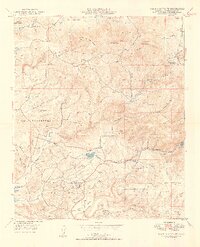
 1947 Ramona1947 Print · USGSSan Diego’s inland valleys and mountain ranges appear in detail during the late 1940s as ranching and forestry shaped the region. Genealogists and local historians can locate early homesteads like Vineyard Ranch and trace the boundaries of the Mesa Grande Ind Res or San Pasqual Indian Reservation.
 - 1947 Map of El Cajon
 1947 El Cajon1947 Print · USGSThe San Diego River valley and its surrounding foothills appear in the late thirties, centered on the growing community of El Cajon. Genealogists and historians can trace family holdings like Fanita Ranch or locate the Indian Cem and Dehesa Sch in the southern hills.
 - 1947 Map of Santa Ana, 1949 Print
 1947 Santa Ana1949 Print · USGSSouthern California is depicted here in the late forties, showing the expansion of the Inland Empire and the Orange County coast. Researchers can trace the early layout of Palm Springs or locate long-standing tribal lands like the Pala Indian Reservation and Rincon Indian Res.
 - 1948 Map of Rancho Santa Fe, 1955 Print
 1948 Rancho Santa Fe1955 Print · USGSCoastal San Diego County appears here shortly after the war, when the landscape was still defined by large ranchos and quiet canyons. Genealogists and local historians can trace the footprint of Rancho Santa Fe, find early mining sites like the Pyrophyllite Mine, or locate ancient Petroglyphs.3 unique versions available
 - 1948 Map of Escondido, 1958 Print
 1948 Escondido1958 Print · USGSEscondido and the surrounding valleys of San Diego County are captured here just after the war as agriculture and early suburban growth began to meet. Genealogists can locate family holdings like Cloverdale Ranch or trace the historic Bernardo Winery and the original A T & S F rail alignment.2 unique versions available
 - 1949 Map of Rancho Santa Fe
 1949 Rancho Santa Fe1949 Print · USGSNorth coastal San Diego County is shown here in the late 1940s, a landscape of sprawling ranchos and early hilltop settlements. Researchers can trace historic boundaries like Los Encenitos and locate landmarks such as Olivenhain and the Pyrophyllite Mine.2 unique versions available
 - 1949 Map of Escondido
 1949 Escondido1949 Print · USGSPost-war San Diego County comes to life as the city of Escondido expands into the surrounding Rincon Del Diablo. Genealogists and historians can trace old property lines and landmarks like the Bernardo Winery, Del Dios, and the Union Elementary Schools.2 unique versions available
 - 1949 Map of Santa Ana
 1949 Santa Ana1949 Print · USGSSouthern California underwent a profound transformation in the late 1940s as military installations and citrus groves shared the landscape. Researchers can trace early coastal growth at Laguna Beach, military history at Camp Pendleton, and the rail corridors of the Pacific Electric.
End of results
Showing maps 1-20 of 20
Top cities near San Diego
- Chula Vista historical maps
- El Cajon historical maps
- Encinitas historical maps
- La Mesa historical maps
- Santee historical maps
- National City historical maps
See more
Top neighborhoods of San Diego
- San Pasqual historical maps
- Del Cerro historical maps
- Sorrento Valley historical maps
- San Carlos historical maps
- Allied Gardens historical maps
- Rancho Peñasquitos historical maps
See more
Frequently asked questions
- What are the different types of historical maps available for San Diego?
- What is the oldest map of San Diego?
- Where can I purchase historical maps of San Diego for my home or office?
- Where can I download high-res historical maps of San Diego?
- Are there historical topographic maps available for San Diego?
- Is there historical aerial imagery available for San Diego?
- Where are historical maps of San Diego sourced from?