1960s Maps of Santa Clara County, California
Explore 19 historic maps of Santa Clara County from the 1960s. These maps offer a rare glimpse into what life looked like during the 1960s — showing old roads, neighborhoods, homes, and landmarks that have changed or disappeared over time.
Whether you're researching your family's past, planning a metal detecting trip, or studying how Santa Clara County's landscape evolved across the 1960s, these high-resolution maps are a powerful tool for exploring the history of this region.
- Focus on a specific era: All maps on this page are from the 1960s, giving you a focused view of this time period.
- See what’s changed: Compare century-old streets, trails, and buildings to today's modern landscape using overlays and satellite layers.
- Research with precision: Use these maps for genealogy, historical research, land use analysis, or educational projects.
- View, download, or print: Maps are fully viewable online in high resolution, and can be downloaded or printed for your own records.
Start exploring Santa Clara County's history through authentic maps from the 1960s. This is your window into the past.
Santa Clara County, CA maps
(19)- 1960 Map of San Francisco
 1960 San Francisco1960 Print · USGSThe San Francisco Bay Area at the start of the sixties reveals a landscape of rapid expansion and critical infrastructure. Researchers can trace the development of East Bay communities like Russell City and Mt Eden or locate early rural landmarks like Alpine School.
 - 1961 Map of Mindego Hill
 1961 Mindego Hill1961 Print · USGSThe Santa Cruz Mountains in the early sixties reveal a landscape of secluded ranches and early industrial sites. Genealogists and local historians can trace the foundations of Portola State Park, the old Coal Mine, and historic ranch lands like Pony Tracks Ranch.5 unique versions available
 - 1961 Map of Mountain View
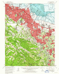
 1961 Mountain View1961 Print · USGSThe South Bay shoreline and Peninsula suburbs undergo rapid mid-century growth in this detailed record. Genealogists and local historians can trace the development of Mountain View and Sunnyvale alongside landmarks like Moffett Field and Alta Mesa Cem.5 unique versions available
 - 1961 Map of San Francisco
 1961 San Francisco1961 Print · USGSThe Bay Area at the dawn of the 1960s reveals a landscape of growing cities and massive Cold War military installations. Genealogists and historians can trace the mid-century urban footprint from Berkeley to San Mateo, while locating landmarks like the Presidio, Alcatraz Island, and Moffett Field Air Station.
 - 1961 Map of San Jose East, 1962 Print
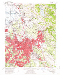
 1961 San Jose East1962 Print · USGSThe eastern edges of San Jose are captured here during a period of rapid suburban growth in the early sixties. Researchers can trace family roots through numerous local schools and cemeteries or locate lost landmarks like the San Jose Speedway and Reids Hillview Airport.5 unique versions available
 - 1961 Map of Milpitas, 1962 Print
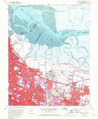
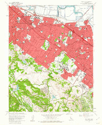
 1961 Milpitas1962 Print · USGSThe South Bay marshlands and the Santa Clara Valley transition from an agricultural past to an industrial future in the early sixties. Researchers can trace the layout of Agnews State Hospital, the isolated rail stop at Drawbridge, and the massive Automobile Assembly Plant.7 unique versions available
 - 1961 Map of Palo Alto, 1962 Print
 1961 Palo Alto1962 Print · USGSThe Peninsula experienced a period of significant growth in the early sixties, as residential tracts filled the spaces between historic estates. Researchers can trace the mid-century footprints of Stanford University, St Patricks Seminary, and Alta Mesa Cem amidst a network of Salt Evaporators.4 unique versions available
 - 1961 Map of Calaveras Reservoir, 1962 Print
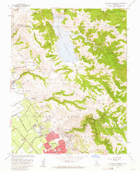 1961 Calaveras Reservoir1962 Print · USGSSanta Clara County’s rugged eastern foothills meet the growing valley suburbs in the early sixties. Genealogists and local historians can trace the footprint of the Berryessa community and old rural schools like Air Point Sch and Rose Sch.9 unique versions available
 - 1961 Map of Cupertino, 1962 Print
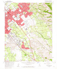
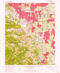 1961 Cupertino1962 Print · USGSSanta Clara County is in the midst of its mid-century transformation from orchards to an urban hub during the early sixties. Genealogists and researchers can trace local landmarks like Loyola Corners, the sprawling Cement Plant, and historic schools from Fremont High Sch to Monta Vista.7 unique versions available
 - 1961 Map of San Jose West, 1962 Print
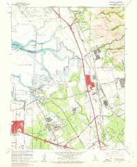
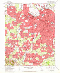 1961 San Jose West1962 Print · USGSThe Santa Clara Valley undergoes a massive mid-century transformation as the suburbs of San Jose and Campbell expand. Trace family roots at the Mission Santa Clara de Asis or locate mid-century landmarks like Willow Glen and Vasona Junction.6 unique versions available
 - 1961 Map of San Jose, 1963 Print
 1961 San Jose1963 Print · USGSThe Santa Clara Valley undergoes a massive post-war transformation in the early sixties as suburbs sprawl toward the bay. Genealogists and local historians can trace the development of SUNNYVALE, the grounds of Agnews State Hospital, and the rail corridors of the Southern Pacific.2 unique versions available
 - 1961 Map of Palo Alto, 1963 Print
 1961 Palo Alto1963 Print · USGSThe mid-century Santa Clara Valley comes into focus here as early tech and aerospace hubs began transforming the peninsula. Genealogists and researchers can trace local institutions and schools like STANFORD UNIVERSITY, Alta Mesa Cem, and NAVAL AIR STATION MOFFETT FIELD.3 unique versions available
 - 1962 Map of San Jose
 1962 San Jose1962 Print · USGSCentral California in the early sixties showcases the expansion of the San Joaquin and Santa Clara valleys. Researchers can trace the rail-to-road transition along the Southern Pacific RR or locate landmarks like Castle USAF Base and Loma Prieta.4 unique versions available
 - 1963 Map of Mt. Hamilton
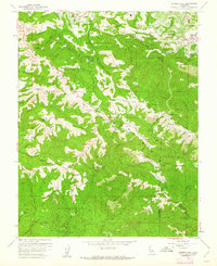
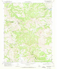
 1963 Mt. Hamilton1963 Print · USGSThe Diablo Range heights of Santa Clara County are captured here just after the war, showing the mountain ranching life and scientific outposts. Genealogists and local historians can trace family lands like Patton Ranch, the Halls Valley Sch, and the high-altitude Lick Observatory.
 - 1964 Map of San Francisco
 1964 San Francisco1964 Print · USGSThe Bay Area in the mid-sixties shows a region of rapid suburban expansion and major military installations. Researchers can trace the development of the South Bay near Stanford University or locate family plots in the historic Cypress Lawn Cem and Holy Cross Cem.
 - 1965 Map of Santa Cruz, 1968 Print
 1965 Santa Cruz1968 Print · USGSThe Central Coast and San Joaquin Valley meet here during the mid-sixties, capturing the growth of agricultural and coastal hubs. Trace the historic Southern Pacific RR lines and locate sites like the Presidio of Monterey or Pinnacles National Monument.
 - 1966 Map of San Jose
 1966 San Jose1966 Print · USGSCentral California in the mid-1960s reveals a landscape of massive irrigation projects and expanding Cold War military footprints. Researchers can trace the rail-and-river network of the San Joaquin Valley or locate specialized sites like Castle Air Force Base and the Sharp General Depot (Military).
 - 1967 Map of Mt. Hamilton
 1967 Mt. Hamilton1967 Print · USGSSanta Clara County’s eastern ridges are captured here in the mid-1960s, centered on the high-altitude research outpost at Lick Observatory. Researchers can trace old family holdings and remote landmarks like Grant Ranch, Evergreen Ranch, and Copernicus Pk.
 - 1969 Map of Mariposa Peak, 1971 Print
 1969 Mariposa Peak1971 Print · USGSThe high ridges and deep canyons of the Diablo Range are meticulously documented here in the late sixties. Local historians can trace old property lines at French Ranch and locate historical mining operations such as the Stayton Mine or the Mariposa Mine.3 unique versions available
End of results
Showing maps 1-19 of 19
Top cities of Santa Clara County
- San Jose historical maps
- Sunnyvale historical maps
- Santa Clara historical maps
- Milpitas historical maps
- Mountain View historical maps
- Palo Alto historical maps
See more
Frequently asked questions
- What are the different types of historical maps available for Santa Clara County?
- What is the oldest map of Santa Clara County?
- Where can I purchase historical maps of Santa Clara County for my home or office?
- Where can I download high-res historical maps of Santa Clara County?
- Are there historical topographic maps available for Santa Clara County?
- Is there historical aerial imagery available for Santa Clara County?
- Where are historical maps of Santa Clara County sourced from?