1970s Maps of Santa Clara County, California
Explore 5 historic maps of Santa Clara County from the 1970s. These maps offer a rare glimpse into what life looked like during the 1970s — showing old roads, neighborhoods, homes, and landmarks that have changed or disappeared over time.
Whether you're researching your family's past, planning a metal detecting trip, or studying how Santa Clara County's landscape evolved across the 1970s, these high-resolution maps are a powerful tool for exploring the history of this region.
- Focus on a specific era: All maps on this page are from the 1970s, giving you a focused view of this time period.
- See what’s changed: Compare century-old streets, trails, and buildings to today's modern landscape using overlays and satellite layers.
- Research with precision: Use these maps for genealogy, historical research, land use analysis, or educational projects.
- View, download, or print: Maps are fully viewable online in high resolution, and can be downloaded or printed for your own records.
Start exploring Santa Clara County's history through authentic maps from the 1970s. This is your window into the past.
Santa Clara County, CA maps
(5)- 1971 Map of San Francisco
 1971 San Francisco1971 Print · USGSThe San Francisco Bay Area at the start of the 1970s is shown here as a dense network of aerospace hubs, naval bases, and expanding suburbs. Researchers can trace the mid-century footprint of Stanford University, the industrial Salt Evaporators, and the Southern Pacific rail lines.
 - 1973 Map of Gilroy, 1979 Print
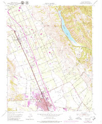 1973 Gilroy1979 Print · USGSThe Santa Clara Valley transitions from agrarian roots to suburban growth in the early seventies. Genealogists can locate family names and sites like Sun Martin, St Marys Sch, and the Southern Pacific rail line.
 - 1974 Map of Monterey, 1977 Print
 1974 Monterey1977 Print · USGSThe Central Coast and San Joaquin Valley meet in this mid-seventies survey of the Monterey region. Genealogists and historians can locate Spanish-era sites like the San Antonio de Padua Mission, early industrial markers such as the New Idria Mine, and coastal landmarks like the Point Sur Lighthouse.
 - 1978 Map of San Jose
 1978 San Jose1978 Print · USGSSanta Clara County and the East Bay hills are captured in the late seventies, showing the suburban sprawl of San Jose alongside the rural Central Valley. Trace the paths of the Southern Pacific railroad and find landmarks like New Almaden and Lick Observatory.
 - 1978 Map of Mariposa Peak, 1982 Print
 1978 Mariposa Peak1982 Print · USGSThe high ridges of the Diablo Range meet the San Joaquin Valley watershed in the late sixties, revealing a landscape of remote ranching and mineral exploration. Genealogists and researchers can trace family-named locations like French Ranch and Pfeiffer Ranch alongside legacy sites like the Mariposa Mine.
End of results
Showing maps 1-5 of 5
Top cities of Santa Clara County
- San Jose historical maps
- Sunnyvale historical maps
- Santa Clara historical maps
- Milpitas historical maps
- Mountain View historical maps
- Palo Alto historical maps
See more
Frequently asked questions
- What are the different types of historical maps available for Santa Clara County?
- What is the oldest map of Santa Clara County?
- Where can I purchase historical maps of Santa Clara County for my home or office?
- Where can I download high-res historical maps of Santa Clara County?
- Are there historical topographic maps available for Santa Clara County?
- Is there historical aerial imagery available for Santa Clara County?
- Where are historical maps of Santa Clara County sourced from?