1900s (20th Century) Maps of Santa Clara County, California
Explore 123 historic maps of Santa Clara County from the 1900s (20th Century). These maps offer a rare glimpse into what life looked like during the 1900s — showing old roads, neighborhoods, homes, and landmarks that have changed or disappeared over time.
Whether you're researching your family's past, planning a metal detecting trip, or studying how Santa Clara County's landscape evolved across the 1900s, these high-resolution maps are a powerful tool for exploring the history of this region.
- Focus on a specific era: All maps on this page are from the 1900s, giving you a focused view of this time period.
- See what’s changed: Compare century-old streets, trails, and buildings to today's modern landscape using overlays and satellite layers.
- Research with precision: Use these maps for genealogy, historical research, land use analysis, or educational projects.
- View, download, or print: Maps are fully viewable online in high resolution, and can be downloaded or printed for your own records.
Start exploring Santa Clara County's history through authentic maps from the 1900s. This is your window into the past.
Santa Clara County, CA maps
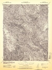
(123)- 1902 Map of Santa Cruz
 1902 Santa Cruz1902 Print · USGSCoastal California at the end of the Victorian era reveals a landscape of redwood forests, early university towns, and remote Pacific outposts. Genealogists and historians can trace the early rail corridors through Boulder Creek and Felton or locate coastal landmarks like Pigeon Point and Halfmoon Bay.9 unique versions available
 - 1915 Map of San Juan Bautista
 1915 San Juan Bautista1915 Print · USGSCentral Coast agriculture and railroad expansion converge in this 1910s study of the Pajaro Valley. Local historians can trace the Southern Pacific line past Watsonville Junction to the Mission San Juan Bautista.
 - 1916 Map of New Almaden
 1916 New Almaden1916 Print · USGSThe Santa Cruz Mountains and the Guadalupe River watershed are captured here during the mid-1910s. Researchers can trace the rail-to-mine connections of New Almaden or locate early schools like Vinehill School and the (Abandoned Town) near Almaden Canyon.
 - 1917 Map of Morgan Hill
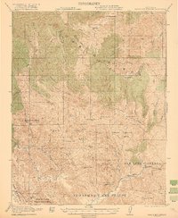
 1917 Morgan Hill1917 Print · USGSSanta Clara County during the early twentieth century is captured here as a valley of orchards and growing rail towns. Genealogists can locate specific family sites like Bradleys Store or trace rural attendance at Machado School and Uvas School.5 unique versions available
 - 1917 Map of San Juan Bautista
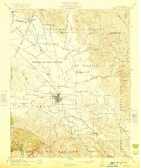
 1917 San Juan Bautista1917 Print · USGSThe fertile valleys of the Central Coast meet at the foot of the Santa Cruz Mountains during this era of agricultural expansion. Genealogists can trace family names across huge land grants and locate historic sites like Mission San Juan Bautista and the St Francis Orphan Asylum.6 unique versions available
 - 1919 Map of Hollister
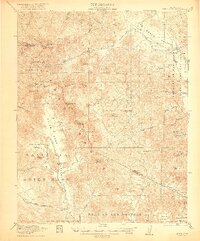
 1919 Hollister1919 Print · USGSThe Santa Clara and San Benito county line area in the late nineteen-teens shows a landscape of expansive ranches and rural school districts. Genealogists can trace early homesteads and family names at Pacheco Ranch, San Justo School, and Dunneville.
 - 1919 Map of New Almaden, 1928 Print
 1919 New Almaden1928 Print · USGSThe Santa Cruz Mountains and the mercury mining district at New Almaden are shown here as they appeared just after the first world war. Researchers can trace the Southern Pacific rail line and locate numerous rural schoolhouses like Summit School and Eureka School.4 unique versions available
 - 1920 Map of Pacheco Pass
 1920 Pacheco Pass1920 Print · USGSThe Pacheco Pass gateway and the eastern Diablo Range are captured here during the early twentieth century. Researchers can trace historic local life through sites like the Bald Eagle Mine, San Luis Ranch, and Cottonwood School.4 unique versions available
 - 1921 Map of Gilroy Hot Springs
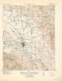
 1921 Gilroy Hot Springs1921 Print · USGSThe Diablo Range east of Gilroy reveals a landscape of massive land grants and remote ranching outposts in the early twentieth century. Genealogists and historians can trace family holdings like the Robeson Ranch or locate the historic Bells Station near Pacheco Pass.4 unique versions available
 - 1921 Map of Hollister
 1921 Hollister1921 Print · USGSThe San Benito and San Justo valleys come alive in this post-World War I era survey of the Hollister region. Researchers can trace family estates and early landmarks like the County Hospital, Barco Ranch, and the Southern Pacific rail line.4 unique versions available
 - 1922 Map of Quien Sabe
 1922 Quien Sabe1922 Print · USGSThe Diablo Range transitions from rugged peaks to vast historic land grants in the early twentieth century. Researchers can trace remote ranching sites like Buena Vista Ranch, the high-altitude Stayton Mine, and the local Quien Sabe School.4 unique versions available
 - 1923 Map of Hollister, 1955 Print
 1923 Hollister1955 Print · USGSHollister and the surrounding San Benito valley are captured here in the early 1920s as the rail and agricultural networks were fully established. Genealogists can locate family holdings like Indart Ranch and numerous rural landmarks such as Enterprise School and the COUNTY HOSPITAL.
 - 1938 Map of Mt. Boardman, 1957 Print
 1938 Mt. Boardman1957 Print · USGSThe Diablo Range backcountry in the late 1930s is revealed here as a landscape of isolated ranching and mining. Researchers can locate family landmarks like Gerber Ranch or trace the early development of the Western Mine and Shanti Ashrama.3 unique versions available
 - 1939 Map of Morgan Hill, 1957 Print
 1939 Morgan Hill1957 Print · USGSSanta Clara County at the end of the 1930s shows a valley of orchards and ranchlands along the Southern Pacific line. Researchers can trace early school districts at Burnett School and Llagas School, or find vanished community hubs like Bradley Store and the original Old Gilroy.2 unique versions available
 - 1939 Map of Gilroy Hot Springs, 1958 Print
 1939 Gilroy Hot Springs1958 Print · USGSThe Diablo Range in the late thirties was a rugged landscape of high peaks and isolated ranching outposts. Local historians can trace early thoroughfares like Pacheco Pass Road and find family-named landmarks including Robeson Ranch and Gilroy Hot Springs.
 - 1939 Map of San Juan Bautista, 1958 Print
 1939 San Juan Bautista1958 Print · USGSThe Central Coast landscape at the dawn of World War II is documented here, showing the intersection of Spanish-era ranchos and the Southern Pacific rail line. Researchers can trace the grounds of Mission San Juan Bautista, identify the Sargent Oil Field, and locate numerous rural schoolhouses like Carlton School.
 - 1940 Map of San Juan Bautista
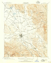
 1940 San Juan Bautista1940 Print · USGSCentral California coastal and valley life at the start of the 1940s is captured here, where four counties meet. Genealogy researchers can trace family-named sites like Patrick Breen, old rural institutions like the St Francis Orphan Asylum, and the early Sargent Oil Fields.
 - 1940 Map of Gilroy Hot Springs
 1940 Gilroy Hot Springs1940 Print · USGSThe Diablo Range rises above the Santa Clara Valley in the early 1940s, showing a landscape of remote cattle ranches and high peaks. Genealogists and hikers can trace historic properties like Robeson Ranch or navigate the routes through Pacheco Pass and Gilroy Hot Springs.
 - 1940 Map of Hollister
 1940 Hollister1940 Print · USGSSan Benito County is shown just before the war as a landscape of productive ranches and emerging civic infrastructure. Genealogists and local historians can trace rural school districts like Anasymas School and the Southern Pacific rail line through Tres Pinos.2 unique versions available
 - 1940 Map of Pacheco Pass
 1940 Pacheco Pass1940 Print · USGSPacheco Pass and the surrounding Merced County foothills are captured here in the years leading up to the war. Genealogists can locate family holdings like Howard Ranch and Fifield Ranch, or trace rural education at Romero School.
 - 1940 Map of Quien Sabe
 1940 Quien Sabe1940 Print · USGSThe San Benito and Merced county lines meet in this 1940 survey of the Diablo Range highlands and interior ranch lands. Researchers can trace the early property lines of the Real de las Aguilas, find the Stayton Mine, and locate the old Quien Sabe School.2 unique versions available
 - 1940 Map of Los Gatos, 1961 Print
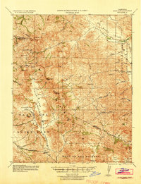
 1940 Los Gatos1961 Print · USGSThe Santa Cruz Mountains and southern Santa Clara Valley appear in the early 1940s, showing a landscape of mountain resorts and isolated summits. Researchers can trace the footprints of Alma College, the community at Holy City, and historical landmarks like Mine Hill.2 unique versions available
 - 1941 Map of Morgan Hill
 1941 Morgan Hill1941 Print · USGSThe Santa Clara Valley corridor comes alive in the early 1940s, showing a landscape of ranchos and rail-side towns. Trace family roots at Redwood School or find old landmarks like Bradley's Store and Madrone Soda Springs.
 - 1941 Map of Palo Alto
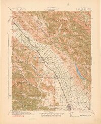
 1941 Palo Alto1941 Print · USGSThe Peninsula and Santa Clara Valley are seen here in the early 1940s, just as the region began its mid-century transformation. Researchers can trace the layout of Stanford University, the military grounds of Moffett Field, and local landmarks like Flood Park.
 - 1942 Map of Mt. Hamilton
 1942 Mt. Hamilton1942 Print · USGSThe Diablo Range heights above San Jose appear here in the early 1940s, centered on the high scientific outpost at Lick Observatory. Researchers can trace old mountain roads and family-held land grants such as the Grant Ranch and Evergreen Ranch.
Showing maps 1-25 of 123
Top cities of Santa Clara County
- San Jose historical maps
- Sunnyvale historical maps
- Santa Clara historical maps
- Milpitas historical maps
- Mountain View historical maps
- Palo Alto historical maps
See more
Frequently asked questions
- What are the different types of historical maps available for Santa Clara County?
- What is the oldest map of Santa Clara County?
- Where can I purchase historical maps of Santa Clara County for my home or office?
- Where can I download high-res historical maps of Santa Clara County?
- Are there historical topographic maps available for Santa Clara County?
- Is there historical aerial imagery available for Santa Clara County?
- Where are historical maps of Santa Clara County sourced from?