1930s Maps of Tulare County, California
Explore 4 historic maps of Tulare County from the 1930s. These maps offer a rare glimpse into what life looked like during the 1930s — showing old roads, neighborhoods, homes, and landmarks that have changed or disappeared over time.
Whether you're researching your family's past, planning a metal detecting trip, or studying how Tulare County's landscape evolved across the 1930s, these high-resolution maps are a powerful tool for exploring the history of this region.
- Focus on a specific era: All maps on this page are from the 1930s, giving you a focused view of this time period.
- See what’s changed: Compare century-old streets, trails, and buildings to today's modern landscape using overlays and satellite layers.
- Research with precision: Use these maps for genealogy, historical research, land use analysis, or educational projects.
- View, download, or print: Maps are fully viewable online in high resolution, and can be downloaded or printed for your own records.
Start exploring Tulare County's history through authentic maps from the 1930s. This is your window into the past.
Tulare County, CA maps
(4)- 1936 Map of White River
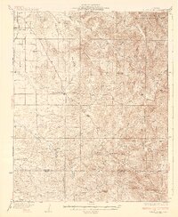 1936 White River1936 Print · USGSIn the foothills of the Sierras during the 1930s, this area shows the transition from valley settlements to upland mines. You can locate rural schools like Grandview Sch and trace the paths to the Last Chance Mine and Fountain Springs.3 unique versions available
 - 1936 Map of Tobias Peak, 1955 Print
 1936 Tobias Peak1955 Print · USGSThe Southern Sierra Nevada and Kern River country are shown here in the mid-1930s as a landscape of remote mining camps and forest stations. Genealogists can locate family names at Oak Grove Cem or trace old workings at the Lone Star Mine and Havilah.
 - 1937 Map of Mt. Whitney, 1954 Print
 1937 Mt. Whitney1954 Print · USGSThe Owens Valley and the High Sierra meet in the late 1930s, showing the early infrastructure of Independence and Lone Pine. Genealogists and historians can trace the Southern Pacific System railroad, the location of Manzanar, and remote sites like Old Camp Independence.3 unique versions available
 - 1937 Map of Kaweah, 1955 Print
 1937 Kaweah1955 Print · USGSHigh Sierra peaks and the Kaweah foothills are captured here in the late 1930s as tourism and resource management shaped the landscape. Genealogists and historians can trace the early layout of Three Rivers, the remote outposts at Mineral King, and the boundaries of the Tule River Indian Reservation.
End of results
Showing maps 1-4 of 4
Top cities of Tulare County
- Visalia historical maps
- Porterville historical maps
- Tulare historical maps
- Dinuba historical maps
- Exeter historical maps
- Lindsay historical maps
See more
Frequently asked questions
- What are the different types of historical maps available for Tulare County?
- What is the oldest map of Tulare County?
- Where can I purchase historical maps of Tulare County for my home or office?
- Where can I download high-res historical maps of Tulare County?
- Are there historical topographic maps available for Tulare County?
- Is there historical aerial imagery available for Tulare County?
- Where are historical maps of Tulare County sourced from?