1940s Maps of Tulare County, California
Explore 23 historic maps of Tulare County from the 1940s. These maps offer a rare glimpse into what life looked like during the 1940s — showing old roads, neighborhoods, homes, and landmarks that have changed or disappeared over time.
Whether you're researching your family's past, planning a metal detecting trip, or studying how Tulare County's landscape evolved across the 1940s, these high-resolution maps are a powerful tool for exploring the history of this region.
- Focus on a specific era: All maps on this page are from the 1940s, giving you a focused view of this time period.
- See what’s changed: Compare century-old streets, trails, and buildings to today's modern landscape using overlays and satellite layers.
- Research with precision: Use these maps for genealogy, historical research, land use analysis, or educational projects.
- View, download, or print: Maps are fully viewable online in high resolution, and can be downloaded or printed for your own records.
Start exploring Tulare County's history through authentic maps from the 1940s. This is your window into the past.
Tulare County, CA maps
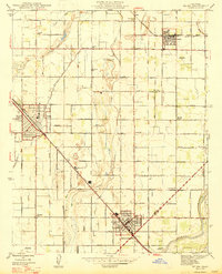
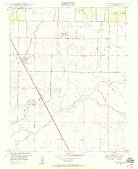
(23)- 1942 Map of Porterville
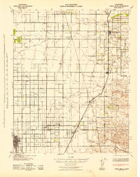
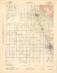 1942 Porterville1942 Print · USGSThe Tulare County citrus and farming belt is captured here during the early years of the war, showing a landscape defined by irrigation and rail. Genealogists can locate family sites near numerous rural schools like Vandalia Sch and Rockford Sch, or trace the old rail lines serving Strathmore and Plano.2 unique versions available
 - 1942 Map of Earlimart
 1942 Earlimart1942 Print · USGSThe southern San Joaquin Valley comes alive in the early 1940s, showing a grid of irrigation canals and major rail lines. Genealogists and historians can trace the foundations of Allensworth, locate numerous sportsmen's outposts like the Widgeon Gun Club, and follow the historic Southern Pacific route.2 unique versions available
 - 1942 Map of Corcoran
 1942 Corcoran1942 Print · USGSThe Central Valley agricultural landscape of Kings and Tulare counties is shown here during the early years of the war. Genealogists and historians can trace rail-side commerce and rural schooling at Waukena, Corcoran, and several family outposts like the El Rico Ranch.
 - 1942 Map of Liberty Farms
 1942 Liberty Farms1942 Print · USGSThe reclaimed basin of Kings County is shown at the height of its early industrial ranching era, just after the turn of the decade. Genealogists and historians can trace the vast holdings of Harvester Ranch, Hacienda Ranch, and the Westlake Gun Club.2 unique versions available
 - 1942 Map of Terra Bella
 1942 Terra Bella1942 Print · USGSThe San Joaquin Valley's agricultural heartland is captured here during the early 1940s, highlighting the vital rail-and-water network of the Tulare-Kern border. Researchers can trace historic family holdings like Menne Ranch or locate vanished rural schoolhouses such as Columbine Sch and Saucelito Sch.
 - 1942 Map of Tulare
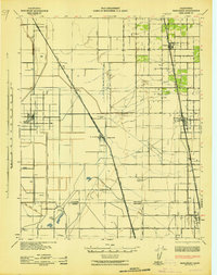
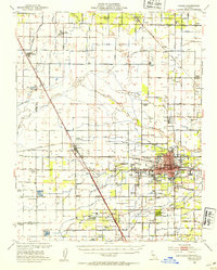
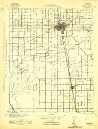 1942 Tulare1942 Print · USGSTulare County's agricultural and rail landscape is meticulously detailed in the early 1940s as the Central Valley irrigation system expanded. Genealogists can locate family-named landmarks and rural schoolhouses like Bliss Sch, Linder Sch, and the settlement of Tipton.2 unique versions available
 - 1942 Map of Dunlap, 1962 Print
 1942 Dunlap1962 Print · USGSThe Sierra Nevada foothills were a patchwork of family ranches and rural schoolhouses during the early 1940s. Genealogists can trace local roots at Auckland Ranch, Squaw Valley Sch, and the community at Miramonte.2 unique versions available
 - 1943 Map of Tobias Peak
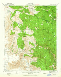
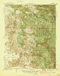
 1943 Tobias Peak1943 Print · USGSThe southern Sierra Nevada foothills in the early 1940s are defined by high-elevation meadows and a legacy of mountain ranching. Researchers can locate early schools and mines, including Greenhorn Sch, the Tungsten Mine, and the historic mining camp of Keysville.2 unique versions available
 - 1944 Map of Dunlap
 1944 Dunlap1944 Print · USGSThe Sierra Nevada foothills come alive in this mid-forties survey of the rugged Fresno and Tulare county line. Genealogists can trace early homesteads and family holdings like Auckland Ranch, Baker Ranch, and the Squaw Valley Sch.2 unique versions available
 - 1945 Map of Tobias Peak
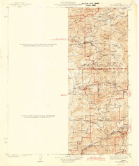
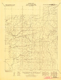 1945 Tobias Peak1945 Print · USGSTulare and Kern County mountain territories are captured here at the end of the Second World War. Researchers can trace high-country life through old outposts like Hot Springs, Pine Flat, and Cranston, or locate early meadows such as Double Bunk.
 - 1946 Map of Selma, 1954 Print
 1946 Selma1954 Print · USGSFresno County's agricultural heartland is captured here in the mid-1940s, showing the extensive irrigation network supporting the valley's towns. Genealogists can locate family landmarks like Kings River Cemetery, Fruitvale School, and the Swedish Mission.2 unique versions available
 - 1946 Map of Selma, 1958 Print
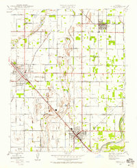 1946 Selma1958 Print · USGSThe fruit-growing heart of the San Joaquin Valley is mapped here just after the war as irrigation and rail lines fueled the growth of the Selma area. Genealogists and local historians can locate rural landmarks like Swedish Mission, Wineland, and the Oddfellows Cem.2 unique versions available
 - 1947 Map of Selma
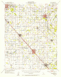
 1947 Selma1947 Print · USGSThe fertile plains of Fresno County thrive in the late 1940s, anchored by the rail-centered towns of Selma and Kingsburg. Genealogists can trace family landmarks like Odd Fellows Cem or local schoolhouses such as Fruitvale Sch and Harrison Sch.2 unique versions available
 - 1947 Map of Trona, 1948 Print
 1947 Trona1948 Print · USGSThe Mojave Desert and Southern Sierra foothills come alive in the late 1940s, showing the industrial nodes of the Argus Range and the burgeoning Camp Irwin. Trace the legacy of desert mining and railroading through Trona, the Ashford Mill, and the historic districts of Randsburg and Garlock.
 - 1948 Map of Trona
 1948 Trona1948 Print · USGSThe Mojave Desert and Death Valley frontier appear here during a mid-century era of military expansion and industrial mining. Trace the remnants of the Old Spanish Trail or locate isolated landmarks like Ashford Mill and the mining hub of Randsburg.
 - 1948 Map of Bakersfield
 1948 Bakersfield1948 Print · USGSBakersfield and the southern San Joaquin Valley appear in the late 1940s, showing a landscape of burgeoning oil towns, rail junctions, and early irrigation canals. Genealogists and historians can trace the foundations of local industry through Gardner Field, the Sunset Railway, and the shores of Buena Vista Lake.2 unique versions available
 - 1948 Map of Fresno
 1948 Fresno1948 Print · USGSThe San Joaquin Valley and the High Sierra met during a period of rapid post-war growth and industrial expansion. Genealogists and researchers can trace family lines through small rail towns like Calwa City, find early aviation sites at Fresno-Chandler, or locate the Fresno Copper Mine.
 - 1949 Map of Visalia, 1954 Print
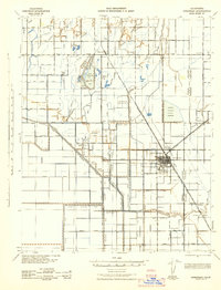
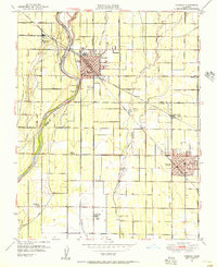
 1949 Visalia1954 Print · USGSMid-century Tulare County thrives as a concentrated agricultural powerhouse centered on the growing city of Visalia. Genealogists and researchers can trace the unique network of the Tagus Ranch worker camps or locate family sites near the College of the Sequoias and Veva Blunt Sch.2 unique versions available
 - 1949 Map of Reedley, 1958 Print
 1949 Reedley1958 Print · USGSThe Fresno and Tulare county line follows the river-fed agricultural heartland in the late 1940s. Genealogists can locate family landmarks like Windsor School, Delft Colony, and the rail junction at Lacjac.
 - 1949 Map of Monson, 1958 Print
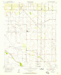 1949 Monson1958 Print · USGSPost-war Tulare County is captured here as a landscape of orchards and irrigation during the late forties. Genealogists can locate small settlements like Monson and Yettem, or trace rural education at the Elbow Creek School and Chatham School.2 unique versions available
 - 1949 Map of Traver, 1959 Print
 1949 Traver1959 Print · USGSAgricultural Tulare County comes into focus at mid-century as irrigation transformed the landscape around the Southern Pacific line. Genealogists can locate family holdings near Traver, London, and the Wilson Sch.4 unique versions available
 - 1949 Map of Visalia, 1963 Print
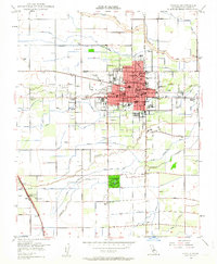 1949 Visalia1963 Print · USGSThe San Joaquin Valley flourishes during this post-war era of irrigation and rail transit. Trace the growth of Visalia through its many local schools and landmarks like Tagus Ranch, Chinowths Corner, and Mooneys Grove Park.4 unique versions available
 - 1949 Map of Goshen, 1971 Print
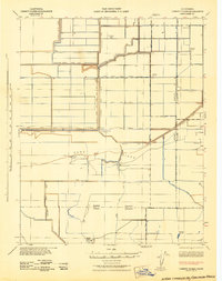
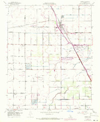 1949 Goshen1971 Print · USGSIn the heart of the San Joaquin Valley during the mid-century, this area shows a landscape defined by industrial agriculture and complex irrigation. Genealogists and historians can trace the worker camps and rural school sites such as Camp Eleven, Manzanillo School, and Overland Ranch.
End of results
Showing maps 1-23 of 23
Top cities of Tulare County
- Visalia historical maps
- Porterville historical maps
- Tulare historical maps
- Dinuba historical maps
- Exeter historical maps
- Lindsay historical maps
See more
Frequently asked questions
- What are the different types of historical maps available for Tulare County?
- What is the oldest map of Tulare County?
- Where can I purchase historical maps of Tulare County for my home or office?
- Where can I download high-res historical maps of Tulare County?
- Are there historical topographic maps available for Tulare County?
- Is there historical aerial imagery available for Tulare County?
- Where are historical maps of Tulare County sourced from?