Old Maps of Tulare County, California for Hiking & Exploration
Hike through history with 689 historic maps of Tulare County. Explore old trails, ghost towns, and forgotten backroads — perfect for outdoor adventurers and local explorers.
- Rediscover forgotten places: Map out old mining camps, roads, and footpaths that no longer exist on modern maps.
- Layer with modern tools: Combine with LiDAR or satellite views to plan hikes through historical terrain.
- Made for exploration: Popular among hikers, overlanders, and local history lovers.
Use these maps to find adventure and explore the hidden past of Tulare County.
Tulare County, CA maps
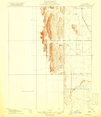
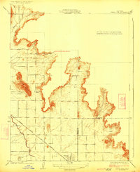
(689)- 1903 Map of Tehipite, 1953 Print
 1903 Tehipite1953 Print · USGSThe High Sierra backcountry in the early twentieth century shows a landscape of early timber works and newly formed preserves. Trace family roots and old park outposts near Hume, Kanawyers, and the historic Abbott Mill.
 - 1904 Map of Kaweah
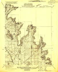
 1904 Kaweah1904 Print · USGSThe southern Sierra Nevada comes alive in this 1904 survey, documenting the early development of Sequoia and the surrounding valleys. Researchers can trace historic irrigation networks like the Whitney Ditch and find early timber sites at Atwells Mill and Dillon Mill.
 - 1905 Map of Tehipite
 1905 Tehipite1905 Print · USGSThe High Sierra at the start of the twentieth century shows a landscape where early tourism and timber industry met. Researchers can trace the original footprint of General Grant National Park and find old lumber sites like Millwood and Harts Sawmill.8 unique versions available
 - 1905 Map of Olancha, 1957 Print
 1905 Olancha1957 Print · USGSThe high Sierra and Owens Valley meet in this 1905 survey, showing the early rail lines and remote outposts before modern infrastructure reached the Kern River. Researchers can trace the path of the Southern Pacific RR through Cartago or locate the remote Kern Canyon Ranger Station.
 - 1905 Map of Fairview, 1957 Print
 1905 Fairview1957 Print · USGSColusa County at the turn of the century reveals a landscape where the Coast Range foothills meet the valley floor. Researchers can trace the path of the Colusa and Lake railroad and locate old watercourses like Freshwater Creek near the settlement of Fairview.
 - 1906 Map of Kernville, 1955 Print
 1906 Kernville1955 Print · USGSThe Kern River Valley at the turn of the century shows a landscape of mining camps and river settlements before the damming of the river. Genealogists and historians can trace the early locations of Kernville, Isabella, and Weldon, or locate the Big Blue Mine and Bodfish P.O.
 - 1907 Map of Olancha
 1907 Olancha1907 Print · USGSThe Sierra Nevada high country at the turn of the century shows a wilderness of meadows and peaks before the modern park era. Trace early trails and remote camps like Funston Camp, Siberian Outpost, and the lake-front settlement of Olancha.9 unique versions available
 - 1907 Map of Mt. Whitney
 1907 Mt. Whitney1907 Print · USGSThe Owens Valley and Sierra high country come alive in this early survey of the Inyo and Tulare border. Genealogists can trace the early layout of Independence and Lone Pine or locate sites like the Bluebell Mine and Old Camp Independence.10 unique versions available
 - 1908 Map of Kernville
 1908 Kernville1908 Print · USGSThe southern Sierra Nevada frontier comes to life in this survey of the Kern River Valley at the dawn of the twentieth century. Genealogists and researchers can locate early mining operations at the Big Blue Mine and trace historic settlements like Vaughn Bodfish P.O. and Weldon before mid-century water projects.6 unique versions available
 - 1909 Map of Kaweah
 1909 Kaweah1909 Print · USGSThe High Sierra and its foothills come to life in this early twentieth-century survey of the western parklands and river valleys. Genealogists and researchers can trace the early homesteads and irrigation systems of Springville, Three Rivers, and the Tule River Indian Res.7 unique versions available
 - 1914 Map of Lost Hills
 1914 Lost Hills1914 Print · USGSThe western San Joaquin Valley appears here as an arid ranching frontier during the early years of oil exploration. Researchers can trace historic travel routes like the Dudley-Lemoore Road and locate isolated landmarks such as McDonalds Ranch, Emigrant Hill, and Alamo Solo Spr.4 unique versions available
 - 1915 Map of Searles Lake
 1915 Searles Lake1915 Print · USGSThe Mojave Desert at the height of its early mining boom features a landscape defined by the Trona RR and the thriving gold camps of the Rand Mountains. Genealogists and historians can trace the foundations of Randsburg, the soda works at Trona, and remote outposts like Muerto Leliter PO and Garlock.6 unique versions available
 - 1918 Map of Fairview
 1918 Fairview1918 Print · USGSColusa County's western valley floor comes into focus during the early twentieth century as agriculture and ranching shaped the land. Researchers can trace the winding Freshwater Creek, the settlement at Fairview, and the historic Colusa and Lake road.2 unique versions available
 - 1919 Map of Mt. Whitney
 1919 Mt. Whitney1919 Print · USGSOwens Valley life and the High Sierra peaks are captured here in the years following the railroad's arrival. Genealogists and historians can trace early settlements and transit routes, from the streets of Independence to the Bluebell Mine and the grounds of Old Camp Independence.
 - 1921 Map of Squaw Valley
 1921 Squaw Valley1921 Print · USGSSettlement and irrigation transform the Sierra foothills in the early twenties as the citrus industry takes root. Genealogists and historians can trace the early grid of Orange Cove and the development of the Citrus Cove School along the Atchison Topeka and Santa Fe line.
 - 1921 Map of Stokes Mountain, 1957 Print
 1921 Stokes Mountain1957 Print · USGSTulare County's foothills come into focus in the early 1920s as agriculture and transport infrastructure began to define the landscape. Local historians can trace the foundations of the rural community through the Elda School and the tracks of the A. T. & S. F. railroad near Stokes Mountain.
 - 1922 Map of Trimmer
 1922 Trimmer1922 Print · USGSThe foothills of eastern Fresno County meet the San Joaquin Valley floor during a period of booming citrus and rail development. Researchers can trace early family-run rangelands and specialized sites like the Wahtoke Winery, the Sunnyside Mine, and the Sycamore Creek Indian School.
 - 1923 Map of Sultana
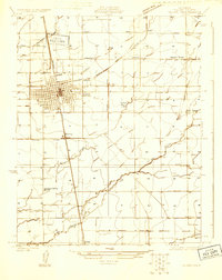
 1923 Sultana1923 Print · USGSCentral Valley agriculture and rail lines dominate the landscape during the early 1920s. Genealogists can trace family footprints near Sultana, Orosi, and Cutler, or locate rural school sites like Mt Olive School.
 - 1924 Map of Reedley
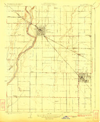 1924 Reedley1924 Print · USGSIn the fertile San Joaquin Valley during the 1920s, the fruit-growing region hummed with activity along the Kings River. Genealogists and historians can trace the development of Reedley and Dinuba while locating rural landmarks like Smith Mountain School and the Advent Church.
 - 1924 Map of Selma
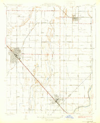 1924 Selma1924 Print · USGSThe San Joaquin Valley's agricultural heartland is captured here in the early 1920s, dominated by the rail corridor connecting Selma and Kingsburg. Family historians can locate rural landmarks like the Danish Church, Swedish Mission, and Walnut School.
 - 1924 Map of Citrus Cove
 1924 Citrus Cove1924 Print · USGSIn the early 1920s, the citrus-growing region at the edge of the Sierra foothills was just beginning its expansion. Researchers can trace the development of Orange Cove and the path of the Atchison Topeka and Santa Fe railroad near Citrus Cove School.2 unique versions available
 - 1924 Map of Dinuba
 1924 Dinuba1924 Print · USGSThe Central Valley meets the Sierra foothills in the early twenties, showing a landscape defined by new canals and citrus groves. Genealogists can locate family holdings like Stair Ranch and dozens of country schools, including the Sycamore Creek Indian School and Great Western School.5 unique versions available
 - 1924 Map of Stokes Mountain
 1924 Stokes Mountain1924 Print · USGSTulare County's eastern foothills come into sharp focus during the early twenties as the region's agricultural and school districts took shape. Genealogists and historians can trace the local landscape near Stokes Mountain, the Elda School, and the A. T. & S. F. rail line.3 unique versions available
 - 1925 Map of Rocky Hill
 1925 Rocky Hill1925 Print · USGSTulare County in the mid-1920s reveals a sophisticated network of irrigation and electric rail servicing the eastern San Joaquin Valley. Researchers can trace early school sites like Lindcove School and the infrastructure of the Visalia Electric and Sides Siding.
 - 1925 Map of Tulare
 1925 Tulare1925 Print · USGSTulare and its surrounding agricultural colonies are captured here in the mid-twenties as the valley's irrigation and rail networks expanded. Researchers can trace the development of small settlements like Burling and Elba alongside early landmarks such as the Oakland Colony School.
Showing maps 1-25 of 689
Top cities of Tulare County
- Visalia historical maps
- Porterville historical maps
- Tulare historical maps
- Dinuba historical maps
- Exeter historical maps
- Lindsay historical maps
See more
Frequently asked questions
- What are the different types of historical maps available for Tulare County?
- What is the oldest map of Tulare County?
- Where can I purchase historical maps of Tulare County for my home or office?
- Where can I download high-res historical maps of Tulare County?
- Are there historical topographic maps available for Tulare County?
- Is there historical aerial imagery available for Tulare County?
- Where are historical maps of Tulare County sourced from?