Old Maps of Tulare County, California
Explore old maps of Tulare County, spanning from 1903 to today. These high-resolution historic maps reveal how streets, neighborhoods, landmarks, and natural features evolved over time — perfect for genealogy, metal detecting, research, and local history exploration.
What you can do with these maps:
- See how Tulare County changed over time: Compare historical maps to modern-day views to trace roads, homesites, rail lines & more.
- View detailed metadata: Each map includes creators, publishers, year, scale, and archive source.
- Overlay maps with satellite & LiDAR: Visualize the past alongside modern tools to explore terrain & human change.
- Trusted historical sources: Maps sourced from the USGS, Library of Congress, and other archives.
- Access maps your way: View online, download high-res files, or order prints for personal or research use.
Start exploring old maps of Tulare County to uncover forgotten places, hidden landmarks, and the deep history beneath your feet.
Tulare County, CA maps
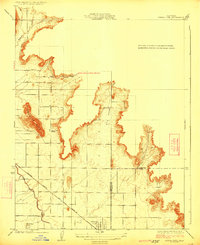
- 1903 Map of Tehipite, 1953 Print
 1903 Tehipite1953 Print · USGSCovers Tulare County, including Cedar Grove, Hartland, and other nearby areas
 - 1904 Map of Kaweah
 1904 Kaweah1904 Print · USGSCovers Tulare County, including Porterville, Springville, and other nearby areas
 - 1905 Map of Tehipite
 1905 Tehipite1905 Print · USGSCovers Tulare County, including Cedar Grove, Hartland, and other nearby areas8 unique versions available
 - 1905 Map of Olancha, 1957 Print
 1905 Olancha1957 Print · USGSCovers Tulare County, including Walker Creek, Sage Flats, and other nearby areas
 - 1905 Map of Fairview, 1957 Print
 1905 Fairview1957 Print · USGSCovers Tulare County, including Fairview, Roads End, and other nearby areas
 - 1906 Map of Kernville, 1955 Print
 1906 Kernville1955 Print · USGSCovers Tulare County, including Lake Isabella, Bodfish, and other nearby areas
 - 1907 Map of Olancha
 1907 Olancha1907 Print · USGSCovers Tulare County, including Walker Creek, Sage Flats, and other nearby areas9 unique versions available
 - 1907 Map of Mt. Whitney
 1907 Mt. Whitney1907 Print · USGSCovers Tulare County, including Lone Pine, Independence, and other nearby areas10 unique versions available
 - 1908 Map of Kernville
 1908 Kernville1908 Print · USGSCovers Tulare County, including Lake Isabella, Bodfish, and other nearby areas6 unique versions available
 - 1909 Map of Kaweah
 1909 Kaweah1909 Print · USGSCovers Tulare County, including Porterville, Springville, and other nearby areas7 unique versions available
 - 1914 Map of Lost Hills
 1914 Lost Hills1914 Print · USGSCovers Tulare County, including Lost Hills, Gilbert Ranch, and other nearby areas4 unique versions available
 - 1915 Map of Searles Lake
 1915 Searles Lake1915 Print · USGSCovers Tulare County, including Ridgecrest, California City, and other nearby areas6 unique versions available
 - 1918 Map of Fairview
 1918 Fairview1918 Print · USGSCovers Tulare County, including Fairview, Roads End, and other nearby areas2 unique versions available
 - 1919 Map of Mt. Whitney
 1919 Mt. Whitney1919 Print · USGSCovers Tulare County, including Lone Pine, Independence, and other nearby areas
 - 1921 Map of Squaw Valley
 1921 Squaw Valley1921 Print · USGSCovers Tulare County, including Orange Cove, Fresno County, and other nearby areas
 - 1921 Map of Stokes Mountain, 1957 Print
 1921 Stokes Mountain1957 Print · USGSCovers Tulare County, including United States, California, and other nearby areas
 - 1922 Map of Trimmer
 1922 Trimmer1922 Print · USGSCovers Tulare County, including Reedley, Dinuba, and other nearby areas
 - 1923 Map of Sultana
 1923 Sultana1923 Print · USGSCovers Tulare County, including Dinuba, Orange Cove, and other nearby areas
 - 1924 Map of Reedley
 1924 Reedley1924 Print · USGSCovers Tulare County, including Reedley, Dinuba, and other nearby areas
 - 1924 Map of Selma
 1924 Selma1924 Print · USGSCovers Tulare County, including Selma, Parlier, and other nearby areas
 - 1924 Map of Citrus Cove
 1924 Citrus Cove1924 Print · USGSCovers Tulare County, including Orange Cove, Fresno County, and other nearby areas2 unique versions available
 - 1924 Map of Dinuba
 1924 Dinuba1924 Print · USGSCovers Tulare County, including Reedley, Dinuba, and other nearby areas5 unique versions available
 - 1924 Map of Stokes Mountain
 1924 Stokes Mountain1924 Print · USGSCovers Tulare County, including United States, California, and other nearby areas3 unique versions available
 - 1925 Map of Rocky Hill
 1925 Rocky Hill1925 Print · USGSCovers Tulare County, including Tooleville, Lindcove, and other nearby areas
 - 1925 Map of Tulare
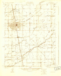 1925 Tulare1925 Print · USGSCovers Tulare County, including Tulare, East Tulare Villa, and other nearby areas
Showing maps 1-25
Top cities of Tulare County
- Visalia historical maps
- Porterville historical maps
- Tulare historical maps
- Dinuba historical maps
- Exeter historical maps
- Lindsay historical maps
See more
Frequently asked questions
- What are the different types of historical maps available for Tulare County?
- What is the oldest map of Tulare County?
- Where can I purchase historical maps of Tulare County for my home or office?
- Where can I download high-res historical maps of Tulare County?
- Are there historical topographic maps available for Tulare County?
- Is there historical aerial imagery available for Tulare County?
- Where are historical maps of Tulare County sourced from?