1950s Maps of Tuolumne County, California
Explore 22 historic maps of Tuolumne County from the 1950s. These maps offer a rare glimpse into what life looked like during the 1950s — showing old roads, neighborhoods, homes, and landmarks that have changed or disappeared over time.
Whether you're researching your family's past, planning a metal detecting trip, or studying how Tuolumne County's landscape evolved across the 1950s, these high-resolution maps are a powerful tool for exploring the history of this region.
- Focus on a specific era: All maps on this page are from the 1950s, giving you a focused view of this time period.
- See what’s changed: Compare century-old streets, trails, and buildings to today's modern landscape using overlays and satellite layers.
- Research with precision: Use these maps for genealogy, historical research, land use analysis, or educational projects.
- View, download, or print: Maps are fully viewable online in high resolution, and can be downloaded or printed for your own records.
Start exploring Tuolumne County's history through authentic maps from the 1950s. This is your window into the past.
Tuolumne County, CA maps
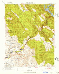
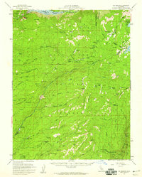
(22)- 1953 Map of Cooperstown, 1955 Print
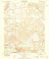 1953 Cooperstown1955 Print · USGSThe Stanislaus and Tuolumne county line comes alive in the 1950s as a landscape of irrigation and heavy industry. Genealogists and historians can trace the Sierra Railroad through Cooperstown or locate the Roberts Ferry School and riverside Dredge Tailings.
 - 1953 Map of Merced Peak, 1955 Print
 1953 Merced Peak1955 Print · USGSThe High Sierra wilderness of the early fifties is mapped here in detail, spanning the boundary of Yosemite and the national forests. Researchers can locate remote outposts and industry like the Strawberry Tungsten Mine, Knoblock Cabin, and the Merced Lake Ranger Sta.7 unique versions available
 - 1953 Map of Mono Craters, 1955 Print
 1953 Mono Craters1955 Print · USGSThe eastern Sierra Nevada meets the high basin in the early 1950s, showing the early development of recreational and industrial corridors. Genealogists and historians can trace high-altitude infrastructure like the Log Cabin Mine, the State Fish Hatchery, and the Mono Lake Aqueduct.6 unique versions available
 - 1954 Map of Pickel Meadow, 1955 Print
 1954 Pickel Meadow1955 Print · USGSThe high Sierra landscape near the Alpine and Mono County line is documented here in the mid-fifties. Researchers can trace the layout of the Marine Corps Cold Weather Camp and locate the historic Leavitt Sta (Site) near Leavitt Meadow.4 unique versions available
 - 1954 Map of Copperopolis, 1956 Print
 1954 Copperopolis1956 Print · USGSThe California foothills in the mid-fifties reveal a transition from gold and copper mining to water management along the Stanislaus River. Locate historic sites like Central Ferry and the Napoleon Mine while tracing the Sierra Railroad.
 - 1954 Map of Merced Falls, 1956 Print
 1954 Merced Falls1956 Print · USGSThe Gold Country foothills meet the Central Valley floor in the mid-1950s, revealing a landscape shaped by river dredging and early reservoirs. Researchers can trace the massive Dredge Tailings near Snelling or locate rural landmarks like Whisky Flat and the Corner Sch.
 - 1956 Map of San Jose
 1956 San Jose1956 Print · USGSCentral California in the mid-fifties reveals the transition from sprawling orchards to growing urban hubs like San Jose and Stockton. Genealogists and historians can trace the rail-era landscape of the Mother Lode through Chinese Camp and Tuttletown, or follow the water through the Joaquin River and Calaveras Reservoir.
 - 1956 Map of Sacramento
 1956 Sacramento1956 Print · USGSMid-century California unfolds from the delta to the high Sierra, capturing a landscape of growing valley cities and burgeoning military airbases. Genealogists and historians can trace the rail lines and river towns from Woodland to Lodi, or explore the foothill settlements of Placerville and Jackson.2 unique versions available
 - 1956 Map of Long Barn, 1959 Print
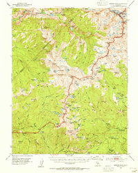
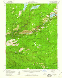
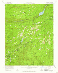 1956 Long Barn1959 Print · USGSTuolumne County in the mid-fifties is a landscape of timber and gold, where logging spurs still wind toward the high Sierra. Genealogists and researchers can trace local family roots through mountain communities like Long Barn, Twain Harte, and Mi-Wuk Village, or locate historic workings such as the Red Cloud Mine.3 unique versions available
 - 1956 Map of Blue Mountain, 1959 Print
 1956 Blue Mountain1959 Print · USGSThe High Sierra backcountry of Amador and Calaveras Counties is shown here in the mid-fifties as forestry and recreation began to overlap. Researchers can find deep-woods sites like Hamilton Camp, the Black Wonder Mine, and the historic Swiss Ranch near Arnold.3 unique versions available
 - 1956 Map of Dardanelles Cone, 1959 Print
 1956 Dardanelles Cone1959 Print · USGSThe High Sierra of Tuolumne and Alpine counties appears here in the mid-fifties, during a peak era of summer camp expansion and reservoir development. Researchers can trace the layout of early recreation sites like the Douglas Resort, Sierra Girl Scout Camp, and Dardanelle PO.3 unique versions available
 - 1956 Map of Big Meadow, 1959 Print
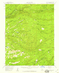
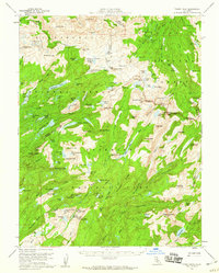
 1956 Big Meadow1959 Print · USGSThe High Sierra backcountry near the Calaveras and Tuolumne border is captured here during the mid-1950s. Local history researchers can trace the locations of Bloods Toll Sta (Site), seasonal retreats like Cuneo Camp, and the early footprint of Calaveras Big Trees State Park.4 unique versions available
 - 1956 Map of Pinecrest, 1959 Print
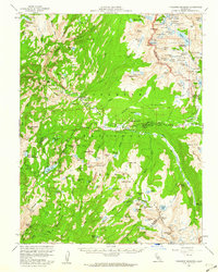
 1956 Pinecrest1959 Print · USGSTuolumne County's High Sierra wilderness is captured here in the mid-fifties, just as mountain recreation and water infrastructure were expanding. Genealogists and hikers can trace the trails around Pinecrest, identify family-named sites like Gianelli Cabin, and locate historic meadows such as Leland Mdw.4 unique versions available
 - 1956 Map of Sonora Pass, 1959 Print
 1956 Sonora Pass1959 Print · USGSThe High Sierra crest near the Mono and Alpine county lines is captured here in the mid-1950s during a period of seasonal mountain use. Researchers can trace the historic Leavitt Sta (Site), locate the Marine Corps Cold Weather Camp, and explore the drainages of the Pickel River and East Fork Carson River.5 unique versions available
 - 1956 Map of Hetch Hetchy Reservoir, 1960 Print
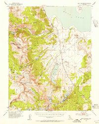
 1956 Hetch Hetchy Reservoir1960 Print · USGSYosemite's northern backcountry and the high Sierra watershed are captured here during the mid-fifties. Researchers can trace the original path of Tioga Road, find old campsites like Smoky Jack Campground, and locate landmarks from White Wolf to Yosemite Village.4 unique versions available
 - 1956 Map of Lake Eleanor, 1960 Print
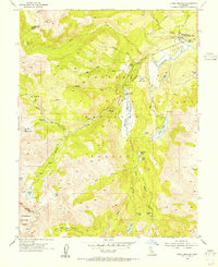
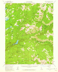
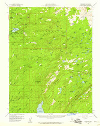
 1956 Lake Eleanor1960 Print · USGSThe high Sierra watershed in the late fifties shows the massive water infrastructure of Hetch Hetchy Reservoir and Cherry Lake. Genealogists and historians can trace legacy sites like Hazel Green Ranch and the early Evergreen Lodge.3 unique versions available
 - 1956 Map of Tower Peak, 1960 Print
 1956 Tower Peak1960 Print · USGSThe High Sierra backcountry near the Tuolumne and Mono County line is documented here in the mid-fifties. Researchers can trace the high-altitude trails to isolated landmarks like Piute Cabin, Sachse Monument, and the high-elevation workings of the Montezuma Mine.4 unique versions available
 - 1956 Map of Matterhorn Peak, 1960 Print
 1956 Matterhorn Peak1960 Print · USGSThe high Sierra wilderness of Mono County in the late 1950s reveals a landscape of remote cattle ranches and high-altitude mining claims. Researchers can trace historic outposts like the McMillan Cabin, early tourism at Mono Village, and the remote May Lundy Mine.4 unique versions available
 - 1956 Map of Tuolumne Meadows, 1960 Print
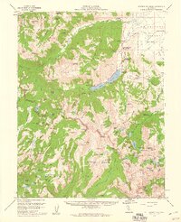
 1956 Tuolumne Meadows1960 Print · USGSTuolumne County in the mid-fifties features a high-country landscape of granite domes and remote camps before the era of modern development. Researchers can trace historic backcountry sites like Parsons Memorial Lodge and the Fahntail Mine or locate early wilderness outposts at May Lake High Sierra Camp.5 unique versions available
 - 1957 Map of Walker Lake
 1957 Walker Lake1957 Print · USGSThe Nevada-California borderlands in the mid-1950s show a rugged network of mining camps and river-valley towns centered around Walker Lake. Researchers can trace the Southern Pacific rail line and locate historical sites like Bodie, Sodaville, and the Leviathan Sulphur Mine.4 unique versions available
 - 1957 Map of Sacramento, 1966 Print
 1957 Sacramento1966 Print · USGSIn the mid-twentieth century, the California heartland was a hub of river transport, rail lines, and military airbases. Genealogists and historians can trace the development of Gold Country towns like Angels Camp and Sonora or follow the path of the Southern Pacific RR through the growing suburbs of Sacramento.4 unique versions available
 - 1957 Map of Mariposa, 1966 Print
 1957 Mariposa1966 Print · USGSThe High Sierra and Owens Valley appear in the mid-fifties, showing the intersection of conservation, hydroelectric power, and mountain industry. Genealogists and researchers can trace local landmarks like Yosemite Cemetery, the remote Kinsley Station, and the Pine Creek Mine.4 unique versions available
End of results
Showing maps 1-22 of 22
Top cities of Tuolumne County
- Sonora historical maps
- Jamestown historical maps
- Sonora Meadows historical maps
- Groveland historical maps
Frequently asked questions
- What are the different types of historical maps available for Tuolumne County?
- What is the oldest map of Tuolumne County?
- Where can I purchase historical maps of Tuolumne County for my home or office?
- Where can I download high-res historical maps of Tuolumne County?
- Are there historical topographic maps available for Tuolumne County?
- Is there historical aerial imagery available for Tuolumne County?
- Where are historical maps of Tuolumne County sourced from?