2020s Maps of Tuolumne County, California
Explore 64 historic maps of Tuolumne County from the 2020s. These maps offer a rare glimpse into what life looked like during the 2020s — showing old roads, neighborhoods, homes, and landmarks that have changed or disappeared over time.
Whether you're researching your family's past, planning a metal detecting trip, or studying how Tuolumne County's landscape evolved across the 2020s, these high-resolution maps are a powerful tool for exploring the history of this region.
- Focus on a specific era: All maps on this page are from the 2020s, giving you a focused view of this time period.
- See what’s changed: Compare century-old streets, trails, and buildings to today's modern landscape using overlays and satellite layers.
- Research with precision: Use these maps for genealogy, historical research, land use analysis, or educational projects.
- View, download, or print: Maps are fully viewable online in high resolution, and can be downloaded or printed for your own records.
Start exploring Tuolumne County's history through authentic maps from the 2020s. This is your window into the past.
Tuolumne County, CA maps
(64)- 2021 Map of Disaster Peak, 2021 Print
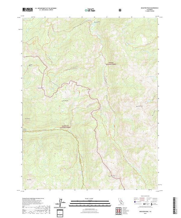 2021 Disaster Peak2021 Print · USGSHigh Sierra wilderness at the junction of Alpine and Tuolumne Counties is preserved here during the early twenty-first century. Hikers and cartographers can trace the Pacific Crest National Scenic Trl as it winds past Disaster Peak and Poison Lake.
 - 2021 Map of Dardanelles Cone, 2021 Print
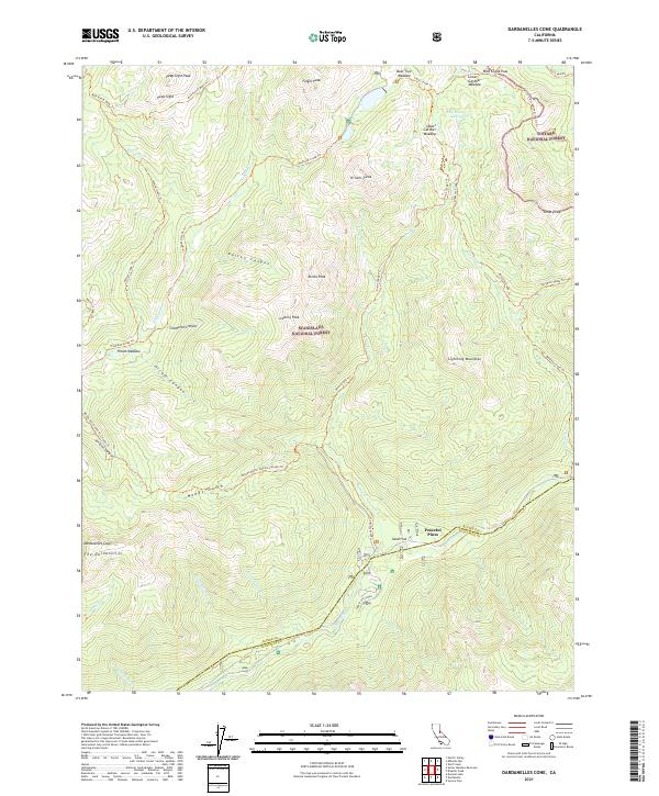 2021 Dardanelles Cone2021 Print · USGSThe high Sierra peaks and forest boundaries of Alpine and Tuolumne counties are shown here as they appeared in the early 2020s. Hikers and researchers can trace the Pacific Crest National Scenic Trl past Wolf Creek Pass and identify landmarks like Dardanelles Cone.
 - 2021 Map of Piute Mountain, 2021 Print
 2021 Piute Mountain2021 Print · USGSYosemite National Park and the high Sierra Nevada backcountry are shown here in the early twenty-first century. Backpackers and researchers can trace the Pacific Crest National Scenic Trl as it passes Benson Lake and climbs through Seavey Pass.
 - 2021 Map of Dardanelle, 2021 Print
 2021 Dardanelle2021 Print · USGSThe High Sierra wilderness near the Tuolumne and Alpine county line is captured here in the early twenty-first century. Researchers can trace forest routes to remote landmarks like the Columns of the Giants, Eagle Meadow, and Haypress Lake.
 - 2021 Map of Pickel Meadow, 2021 Print
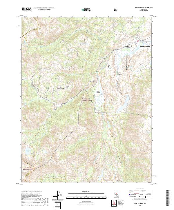 2021 Pickel Meadow2021 Print · USGSThe High Sierra backcountry of Mono County is documented here during the early 2020s, showing a landscape defined by glacial lakes and alpine meadows. Trace the path of the Pacific Crest National Scenic Trl past Leavitt Lake and the waters of Pickel Meadow.
 - 2021 Map of Kibbie Lake, 2021 Print
 2021 Kibbie Lake2021 Print · USGSThe wilderness of Tuolumne County is documented here in the early twenty-first century as it spans the boundary of two major federal preserves. Hikers and researchers can trace the paths of the Huckleberry Trl and None Trl past remote landmarks like Lord Meadow and Kibbie Lake.
 - 2021 Map of Pinecrest, 2021 Print
 2021 Pinecrest2021 Print · USGSTuolumne County's high-country terrain is captured here in the early twenty-first century, showing the established recreation and water systems of the Sierra Nevada. Trace the forest trails and seasonal meadows that define this landscape, from Leland Reservoir and Pinecrest Lake to the slopes of Dodge Ridge.
 - 2021 Map of Tioga Pass, 2021 Print
 2021 Tioga Pass2021 Print · USGSHigh Sierra crests and alpine lakes define this 2021 survey of the boundary between Yosemite and the Inyo National Forest. Hikers and historians can trace routes to Hess Mine Trl, summit Gaylor Peak, or navigate the shores of Saddlebag Lake.
 - 2021 Map of Jawbone Ridge, 2021 Print
 2021 Jawbone Ridge2021 Print · USGSTuolumne and Mariposa counties meet in this protected forest landscape during the early twenty-first century. Genealogists and local historians can locate the Dudley Cem near Greeley Hill or trace the early paths to Buck Meadows and China Flat.
 - 2021 Map of Moccasin, 2021 Print
 2021 Moccasin2021 Print · USGSTuolumne County's water and mining legacy is detailed here as it appeared in the early 2020s. Researchers can trace historic cemeteries such as the Big Oak Flat Chinese Cem and follow the route of the Hetch Hetchy Aqueduct through Grizzly Gulch.
 - 2021 Map of Falls Ridge, 2021 Print
 2021 Falls Ridge2021 Print · USGSYosemite's high country and the dramatic Tuolumne drainage are captured here in the early twenty-first century. Trekkers and researchers can trace the legendary Pacific Crest National Scenic Trl past Glen Aulin and the granite heights of Pothole Dome.
 - 2021 Map of Keystone, 2021 Print
 2021 Keystone2021 Print · USGSTuolumne County ranch lands and foothills are captured here in the early twenty-first century, showing the intersection of historic transit and modern infrastructure. You can trace the path of the Hetch Hetchy Aqueduct, find the Kistler Ranch Airport, and locate the settlement of Keystone.
 - 2021 Map of Sonora, 2021 Print
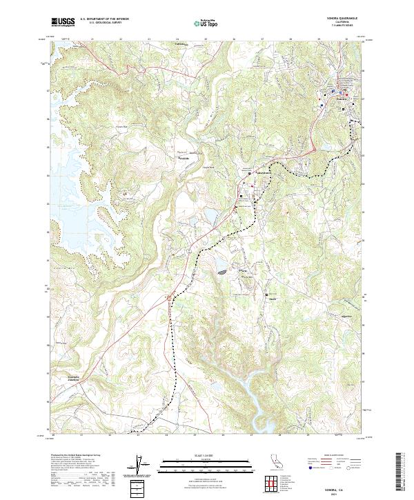 2021 Sonora2021 Print · USGSTuolumne County's historic gold country comes into focus in this contemporary survey of the Mother Lode. Genealogists and researchers can trace lineage through numerous burial sites like Sonora City Cem and Saint James Catholic Cem while exploring the geography of old mining camps near Quartz and Algerine.
 - 2021 Map of Tenaya Lake, 2021 Print
 2021 Tenaya Lake2021 Print · USGSYosemite's high country remains a wilderness of granite domes and alpine lakes in the early twenty-first century. Hikers and historians can trace the paths of the John Muir Trl and Old Tioga Road Trl past landmarks like Clouds Rest and Tenaya Lake.
 - 2021 Map of Coulterville, 2021 Print
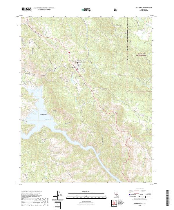 2021 Coulterville2021 Print · USGSMariposa County's rugged Mother Lode country comes into focus in this recent survey of the hills surrounding Coulterville. Local history enthusiasts can trace the old road to Dogtown, locate the Coulterville Chinese Cem, and follow the contours of Lake McClure near Horseshoe Bend.
 - 2021 Map of Hull Creek, 2021 Print
 2021 Hull Creek2021 Print · USGSTuolumne County's high forest terrain is documented here in the early twenty-first century as a hub for mountain recreation and water resources. Trace the historical footprint of mountain life at Deadwood or locate backcountry landmarks like Milk Ranch Spring and Dodge Ridge.
 - 2021 Map of Cherry Lake South, 2021 Print
 2021 Cherry Lake South2021 Print · USGSTuolumne County's high forest and granite ridges are documented here in the early 2020s, showing where the wilderness meets managed forest lands. Hikers and historians can trace the paths of the Andresen Mine Trl, North Mountain Trl, and the shores of Lake Eleanor.
 - 2021 Map of Penon Blanco Peak, 2021 Print
 2021 Penon Blanco Peak2021 Print · USGSMariposa and Tuolumne counties meet in this rugged gold country landscape during the early 2020s. Researchers can trace the interface of modern reservoirs like Lake McClure with historic sites such as Whisky Flat, Granite Springs Cem, and old mining roads.
 - 2021 Map of Chinese Camp, 2021 Print
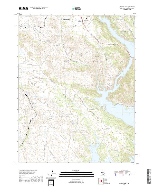 2021 Chinese Camp2021 Print · USGSTuolumne County gold country is documented here in the early twenty-first century as the historic settlement of Chinese Camp meets modern infrastructure. Trace family history through the Chinese Camp City Cem or locate the path of the Hetch Hetchy Aqueduct near Hetch Hetchy Junction.
 - 2021 Map of Yosemite Falls, 2021 Print
 2021 Yosemite Falls2021 Print · USGSThe high granite country of the central Sierra Nevada is captured here in the early twenty-first century, spanning the vertical drop from the peaks to the valley floor. Researchers and hikers can trace the complex paths of the Yosemite Falls Trl and Old Tioga Road Trl past landmarks like North Dome and Eagle Peak.
 - 2021 Map of New Melones Dam, 2021 Print
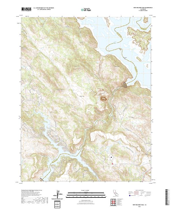 2021 New Melones Dam2021 Print · USGSThe foothills of the Sierra Nevada meet the waters of the Stanislaus River in this recent survey. Researchers can trace the shoreline of New Melones Lake and Tulloch Reservoir while locating historic mining-era sites like Bostick Bar and Vermont Bar.
 - 2021 Map of Groveland, 2021 Print
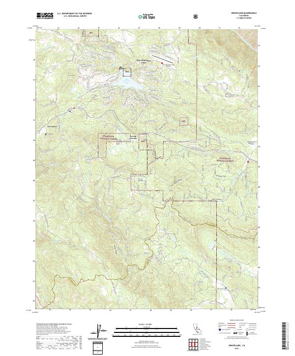 2021 Groveland2021 Print · USGSThe foothills of Tuolumne County appear here in the modern era as a blend of forest lands and residential enclaves. Genealogists and local historians can trace the sites of Second Garrotte, Divide Cem, and the high country of Jackass Ridge.
 - 2021 Map of Cooperstown, 2021 Print
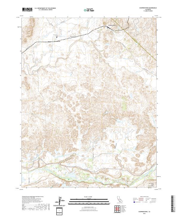 2021 Cooperstown2021 Print · USGSThe foothills of eastern Stanislaus County come to life in this modern survey of the Cooperstown area. Researchers can trace local lineage at the Warnerville Cem or follow the intricate paths of the Modesto Main Canal and the Tuolumne River.
 - 2021 Map of Mount Lyell, 2021 Print
 2021 Mount Lyell2021 Print · USGSThe High Sierra wilderness comes into focus in this modern survey of the tri-county border area. Mountaineers and historians can trace the high-altitude routes of the Isberg Pass Trl and Post Peak Trl between Mt Maclure and Sadler Lake.
 - 2021 Map of Ten Lakes, 2021 Print
 2021 Ten Lakes2021 Print · USGSThe wilderness of the Sierra Nevada is captured here in the early twenty-first century, centered on the dramatic granite architecture of the Tuolumne drainage. Researchers and hikers can trace the descent through the Grand Canyon of the Tuolumne River and find landmarks like Muir Gorge and Ten Lakes Pass.
Showing maps 1-25 of 64
Top cities of Tuolumne County
- Sonora historical maps
- Jamestown historical maps
- Sonora Meadows historical maps
- Groveland historical maps
Frequently asked questions
- What are the different types of historical maps available for Tuolumne County?
- What is the oldest map of Tuolumne County?
- Where can I purchase historical maps of Tuolumne County for my home or office?
- Where can I download high-res historical maps of Tuolumne County?
- Are there historical topographic maps available for Tuolumne County?
- Is there historical aerial imagery available for Tuolumne County?
- Where are historical maps of Tuolumne County sourced from?