1990s Maps of Tuolumne County, California
Explore 46 historic maps of Tuolumne County from the 1990s. These maps offer a rare glimpse into what life looked like during the 1990s — showing old roads, neighborhoods, homes, and landmarks that have changed or disappeared over time.
Whether you're researching your family's past, planning a metal detecting trip, or studying how Tuolumne County's landscape evolved across the 1990s, these high-resolution maps are a powerful tool for exploring the history of this region.
- Focus on a specific era: All maps on this page are from the 1990s, giving you a focused view of this time period.
- See what’s changed: Compare century-old streets, trails, and buildings to today's modern landscape using overlays and satellite layers.
- Research with precision: Use these maps for genealogy, historical research, land use analysis, or educational projects.
- View, download, or print: Maps are fully viewable online in high resolution, and can be downloaded or printed for your own records.
Start exploring Tuolumne County's history through authentic maps from the 1990s. This is your window into the past.
Tuolumne County, CA maps
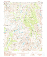
(46)- 1990 Map of Tioga Pass
 1990 Tioga Pass1990 Print · USGSThe high Sierra crest at the close of the twentieth century shows a landscape of alpine research, recreation, and mining history. Trace the trails leading to the Great Sierra Mine, explore the waters of Saddlebag Lake, or locate the Carnegie Institute Experimental Station.
 - 1990 Map of Cherry Lake South
 1990 Cherry Lake South1990 Print · USGSThe high Sierra backcountry in the 1990s reveals a unique intersection of heavy hydropower infrastructure and protected wilderness. Researchers can trace the Old RR Grade and find historic sites like Meyers Ranch and the Woods Ridge Lookout.
 - 1990 Map of Ascension Mountain
 1990 Ascension Mountain1990 Print · USGSThe High Sierra backcountry of Tuolumne County is captured here in the late twentieth century as it borders Yosemite. Researchers can trace the path of the Hetch Hetchy Aqueduct (Tunnel) and locate historic sites like Harden Flat and the Old RR Grade.
 - 1990 Map of Ten Lakes
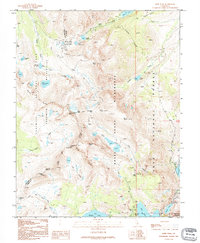
 1990 Ten Lakes1990 Print · USGSHigh Yosemite backcountry comes into focus during the late twentieth century, showing the remote trails and river canyons of the Sierra Nevada. Backpackers and historians can trace the rugged path of the Tuolumne River past Muir Gorge to the heights of Ten Lakes Pass.
 - 1990 Map of Tower Peak
 1990 Tower Peak1990 Print · USGSThe High Sierra wilderness near the Mono and Tuolumne county line comes alive in this 1990s record of alpine terrain and trails. Trace the high-country paths of the Pacific Crest National Scenic Trail past the Montezuma Mine and the remote Piute Cabin.
 - 1990 Map of Tamarack Flat
 1990 Tamarack Flat1990 Print · USGSYosemite's high country is captured in the early nineties, showing the transition from the developed corridor of Tioga Road to the primitive backcountry. Trace the path of the South Fork Tuolumne River or locate remote landmarks like White Wolf and McSwain Meadows.
 - 1990 Map of Ackerson Mountain
 1990 Ackerson Mountain1990 Print · USGSThe high Sierras near the Tuolumne and Mariposa county line are documented here during the 1990s as modern park management met old mountain settlements. Researchers can locate remote outposts like Hazel Green Ranch, the Carlon FS Station, and the historic sequoias of the Tuolumne Grove.
 - 1990 Map of Buckeye Ridge
 1990 Buckeye Ridge1990 Print · USGSThe Eastern Sierra Nevada high country is captured here in the 1990s, where Mono and Tuolumne counties meet along the crest. Researchers can trace the rugged Pack Trail routes connecting Buckeye Pass, Twin Lakes, and the shores of Barney Lake.2 unique versions available
 - 1990 Map of Cooper Peak
 1990 Cooper Peak1990 Print · USGSThe high Sierra backcountry of Tuolumne County is captured here in the late twentieth century, showing a landscape of alpine meadows and granite peaks. Researchers can trace historic grazing sites like Horse and Cow Meadow and remote water features such as Y Meadow Dam or Wire Lakes.2 unique versions available
 - 1990 Map of Yosemite Falls
 1990 Yosemite Falls1990 Print · USGSYosemite Valley and its surrounding high country are captured here in the late 1980s, detailing the valley floor and the peaks above. Trace the trails around Yosemite Village and find remote landmarks like Snow Creek Ranger Cabin, Basket Dome, and Lehamite Falls.
 - 1990 Map of Falls Ridge
 1990 Falls Ridge1990 Print · USGSYosemite's high country is captured here during the late twentieth century as it appeared before many modern trail adjustments. Hikers and historians can trace the classic route of the Pacific Crest National Scenic Trail past Waterwheel Falls and the Glen Aulin High Sierra Camp.
 - 1990 Map of Emigrant Lake
 1990 Emigrant Lake1990 Print · USGSTuolumne County in the 1990s was a landscape of high-elevation wilderness and historic pack routes before more modern restrictions. Researchers can trace alpine trails to Emigrant Lake, locate the Sachse Monument, or find the secluded Sheep Camp and Lunch Meadow.
 - 1990 Map of Mount Lyell
 1990 Mount Lyell1990 Print · USGSHigh Sierra wilderness reaches its peak at the junction of three counties in the 1990s, where the headwaters of the Merced and Lyell Fork emerge. Trace remote alpine routes through Isberg Pass, across the Lyell Glacier, and past Mount Ansel Adams.
 - 1990 Map of Matterhorn Peak
 1990 Matterhorn Peak1990 Print · USGSThe High Sierra near the Tuolumne and Mono county lines is captured here in the 1990s, showcasing the high-altitude wilderness of the Sierra Nevada. You can trace the Pacific Crest National Scenic Trail past Peeler Lake, Matterhorn Peak, and Benson Pass.
 - 1990 Map of Kibbie Lake
 1990 Kibbie Lake1990 Print · USGSThe High Sierra backcountry of Tuolumne County was a pristine wilderness of granite peaks and alpine lakes in the early 1990s. Trace the old Pack Trails connecting remote basins like Many Island Lake and Hyatt Lake within the Emigrant Wilderness.
 - 1990 Map of Hetch Hetchy Reservoir
 1990 Hetch Hetchy Reservoir1990 Print · USGSYosemite's high-country wilderness is captured here in the late twentieth century, showing the flooded valley floor and surrounding granite peaks. Trace backcountry routes along the Pack Trail to remote spots like Tiltill Valley, Smith Peak, and Harden Lake.
 - 1990 Map of Vogelsang Peak
 1990 Vogelsang Peak1990 Print · USGSYosemite's high country is documented in the 1990s as it appeared before modern climate shifts impacted its alpine ice and remote camps. Backcountry researchers can trace the intersection of the John Muir Trail and the Pacific Crest National Scenic Trail near Vogelsang High Sierra Camp and the Maclure Glacier.
 - 1990 Map of Tenaya Lake
 1990 Tenaya Lake1990 Print · USGSHigh Sierra wilderness and alpine lakes define this Mariposa County landscape during the late twentieth century. Hikers and historians can trace the John Muir Trail past Sunrise High Sierra Camp or locate the Tenaya Lake Campground.
 - 1990 Map of Dunderberg Peak
 1990 Dunderberg Peak1990 Print · USGSThe high Sierra Nevada crest comes into focus in 1990, where the Yosemite boundary meets the Hoover Wilderness. Trace remote mining Prospects and high-altitude routes like Kavanaugh Ridge Road and the Cattle Creek Trail.
 - 1990 Map of Piute Mountain
 1990 Piute Mountain1990 Print · USGSThe High Sierra backcountry of Yosemite comes alive in the early nineties, showing a landscape defined by glacial canyons and high-altitude lakes. Trace the Pacific Crest National Scenic Trail as it crosses Seavey Pass between Piute Mountain and Tilden Lake.
 - 1990 Map of Tiltill Mountain
 1990 Tiltill Mountain1990 Print · USGSThe High Sierra backcountry of Tuolumne County is documented here during the late twentieth century, showing the junction of two major wilderness areas. Map collectors and hikers can trace the Pacific Crest National Scenic Trail as it passes Wilma Lake and the granite heights of Tiltill Mountain.
 - 1990 Map of Lake Eleanor
 1990 Lake Eleanor1990 Print · USGSYosemite's high country and the vital waters of the Tuolumne watershed are captured in this 1990 survey. Trace the boundaries of the Yosemite Wilderness and locate landmarks like the O'Shaughnessy Dam, Mather, and Evergreen Lodge.
 - 1992 Map of Koip Peak, 1995 Print
 1992 Koip Peak1995 Print · USGSThe High Sierra crest comes into focus in the early 1990s as a landscape of remote mining claims and protected wilderness. Researchers can trace old mineral works like the Prospect Adit near Mono Pass or follow the Sawmill Canyon Trail past Gem Lake.
 - 1992 Map of Tioga Pass, 1995 Print
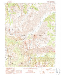
 1992 Tioga Pass1995 Print · USGSThe high Sierra crest at the opening of the 1990s reveals a landscape of scientific research and historic mountaineering. Researchers can locate the Great Sierra Mine, the Carnegie Institute Experimental Station, and the landmark Parsons Memorial Lodge near Soda Springs.
 - 1992 Map of Ten Lakes, 1995 Print
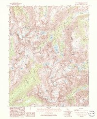
 1992 Ten Lakes1995 Print · USGSThe high Sierra backcountry within Yosemite National Park is captured here during the 1990s before modern digital shifts in wilderness mapping. Hikers and historians can trace the steep routes through the Grand Canyon of the Tuolumne River and find remote water bodies like Ten Lakes and Saddle Horse Lake.
Showing maps 1-25 of 46
Top cities of Tuolumne County
- Sonora historical maps
- Jamestown historical maps
- Sonora Meadows historical maps
- Groveland historical maps
Frequently asked questions
- What are the different types of historical maps available for Tuolumne County?
- What is the oldest map of Tuolumne County?
- Where can I purchase historical maps of Tuolumne County for my home or office?
- Where can I download high-res historical maps of Tuolumne County?
- Are there historical topographic maps available for Tuolumne County?
- Is there historical aerial imagery available for Tuolumne County?
- Where are historical maps of Tuolumne County sourced from?