Old Maps of Tuolumne County, California for Academic Research
Study the evolution of Tuolumne County with 458 high-resolution historic maps. Whether you're teaching, researching, or modeling changes in land use, these maps provide essential visual documentation of urban, environmental, and geographic change.
- Analyze long-term change: Track patterns in development, transportation, and natural features.
- Ideal for environmental or urban studies: Support academic projects with primary historical map data.
- Use in the classroom or lab: Educators and researchers rely on these maps to bring historical context to life.
These maps are a powerful tool for teaching, research, and visualizing how Tuolumne County has changed over the decades.
Tuolumne County, CA maps
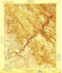
(458)- 1889 Map of Jackson
 1889 Jackson1889 Print · USGSThe Mother Lode foothills thrive in the late nineteenth century as mining and rail expansion reshape the landscape between the San Joaquin Valley and the Sierra Nevada. Genealogists and historians can trace the early layout of Jackson, locate vanished sites like Lancha Plana, and follow the path of the San Joaquin and Sierra Nevada Railroad.
 - 1891 Map of Big Trees
 1891 Big Trees1891 Print · USGSThe Sierra Nevada high country and gold country are seen here in the 1890s, a period defined by the mining economy and early mountain passage. Historians can trace early routes like the Bloods Toll Road and locate sites such as Sheep Ranch, the Keltz Mine, and Swiss Ranch.
 - 1892 Map of Jackson
 1892 Jackson1892 Print · USGSThe California Gold Country comes alive in the late nineteenth century as mining settlements and river-side camps define the landscape. Genealogists and historians can trace family roots through Mokelumne Hill, San Andreas, and the remote Whiskey Slide.
 - 1893 Map of Sonora
 1893 Sonora1893 Print · USGSThe Mother Lode region comes alive in the early 1890s, showing a landscape defined by mining camps and early river crossings before the big dams. Genealogists and historians can trace old settlements like Chinese Camp and Big Oak Flat, or locate industrial sites like the Olsen Mine and Hobron Mill.
 - 1894 Map of Big Trees
 1894 Big Trees1894 Print · USGSCentral California's high Sierra region is documented here in the 1890s, where river crossings and giant sequoia groves defined the landscape. Researchers can trace old mountain routes through Abbott Ferry and Parrott Ferry or locate early mining sites like the Riverside Mine.
 - 1896 Map of Dardanelles
 1896 Dardanelles1896 Print · USGSThe high Sierra wilderness in the late 1890s reveals a landscape of early forest reserves and remote outposts. Trace the early boundaries of Yosemite National Park and find historic stops like Baker Station and Brightman Flat.2 unique versions available
 - 1896 Map of Sonora
 1896 Sonora1896 Print · USGSThe Mother Lode gold country is shown in the late nineteenth century as mining towns and river crossings defined the Sierra Nevada foothills. Genealogists and researchers can trace early routes through Chinese Camp and Coulterville, or locate industrial sites like the Red Cloud Mine and Benton Mill.
 - 1897 Map of Jackson
 1897 Jackson1897 Print · USGSAmador and Calaveras counties are shown here during the late nineteenth-century mining era, when the Mother Lode's river-and-rail economy was in full swing. Genealogists can trace family roots through settlements like Mokelumne Hill, San Andreas, and the remote Whiskey Slide.
 - 1897 Map of Sonora
 1897 Sonora1897 Print · USGSThe Mother Lode region at the close of the nineteenth century is revealed here through its gold-country towns and rugged mining infrastructure. Trace the early footprints of Sonora, Coulterville, and Hornitos alongside sites like the Red Cloud Mine and Ward Ferry.8 unique versions available
 - 1897 Map of Big Trees
 1897 Big Trees1897 Print · USGSThe Sierra Nevada foothills and deep river canyons of the late nineteenth century are mapped here in detail before modern development. Genealogists and historians can trace early mountain life through landmarks like Bloods Toll, the Riverside Mine, and historic crossings at Abbott Ferry.
 - 1897 Map of Yosemite
 1897 Yosemite1897 Print · USGSThe Sierra Nevada high country is captured here during the earliest years of the national park, before major infrastructure changed the landscape. Researchers can locate early homesteads and travel stops like Hog Ranch, Harden Ranch, and Sequoia.
 - 1898 Map of Dardanelles
 1898 Dardanelles1898 Print · USGSThe high Sierra Nevada backcountry comes alive in the late 1890s, centered on the canyons of the Stanislaus and West Walker rivers. Trace early high-country travel routes through Sonora Pass or locate historical stops like Baker Station and the meadows of Brightman Flat.8 unique versions available
 - 1898 Map of Sonora, 1932 Print
 1898 Sonora1932 Print · USGSThe Mother Lode region at the close of the nineteenth century reveals a complex world of river dams and mining camps. Genealogists can trace family names at Chinese Camp or Soulsbyville and locate early industry at the Red Cloud Mine and Bandarita Mine.
 - 1900 Map of Yosemite
 1900 Yosemite1900 Print · USGSThe central Sierra Nevada appears here in the late nineteenth century, prior to the major damming projects that reshaped the river valleys. Genealogists and historians can trace pioneer outposts like Harden Ranch and Hite Cove, or the early tourism hub at Yosemite.
 - 1901 Map of Big Trees
 1901 Big Trees1901 Print · USGSThe High Sierra and Gold Country meet in this turn-of-the-century look at the groves and mining camps of the Mokelumne and Stanislaus watersheds. Trace the early boundaries of the Calaveras Grove, locate the Riverside Mine, or find river crossings like Parrott Ferry.9 unique versions available
 - 1901 Map of Mt. Lyell
 1901 Mt. Lyell1901 Print · USGSThe High Sierra at the end of the century is captured here in immense detail, showing the early boundaries of Yosemite National Park. Researchers can trace old mountain routes past Soda Springs, Tuolumne Meadows, and Miller Bridge.12 unique versions available
 - 1902 Map of Jackson
 1902 Jackson1902 Print · USGSAmador and Calaveras counties are captured at the height of the mining era in this late nineteenth-century survey. Genealogists and historians can trace the rail lines of the Stockton and Copperopolis Railroad and find long-established camps like Lancha Plana and Jesus Maria.7 unique versions available
 - 1903 Map of Yosemite
 1903 Yosemite1903 Print · USGSThe High Sierra and foothills of Mariposa County appear here in the early 1900s, documenting the early ranching and travel networks of the region. Local historians and genealogists can trace family holdings at Harden Ranch, the mining hub of Hite Cove, and the isolated Stage Station.2 unique versions available
 - 1909 Map of Yosemite
 1909 Yosemite1909 Print · USGSMariposa and Tuolumne counties are shown here at the turn of the century, prior to the damming of the Tuolumne River. Researchers can trace early ranching and mining sites like Hog Ranch, Hite Cove, and the historic Stage Station.7 unique versions available
 - 1909 Map of Bridgeport, 1956 Print
 1909 Bridgeport1956 Print · USGSThe High Sierra and Mono Basin are seen here in the decade following the peak of the local gold boom. Genealogists and historians can trace old stage routes and find significant mining sites like the Dunderberg Mine and the remote settlement of Belfort.
 - 1911 Map of Bridgeport
 1911 Bridgeport1911 Print · USGSMono County at the start of the twentieth century was a landscape of high-altitude mining camps and early park boundaries. Trace the footprints of the gold era at Bodie, locate family ranching history at Mormon Ranch, or study the remote Masonic Liberty Mine.7 unique versions available
 - 1915 Map of La Grange, 1957 Print
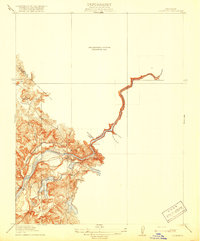
 1915 La Grange1957 Print · USGSThe foothills of the Sierra Nevada meet the valley floor in the early 1900s, centered on the vital waterworks of the Tuolumne River. Researchers can trace the early infrastructure of La Grange Dam and find family-history landmarks like the Live Oak School and Basso Bridge.
 - 1916 Map of Cooperstown
 1916 Cooperstown1916 Print · USGSThe foothills of the Sierra Nevada come alive in the years before the Great War as new irrigation projects reshape the land. Genealogists and historians can trace the early rail stops at Warnerville and Cooperstown or locate the rural Dry Creek School and Hermitage School.
 - 1916 Map of Copperopolis
 1916 Copperopolis1916 Print · USGSCalaveras and Stanislaus counties at the height of the early copper and ranching era reveal a landscape of deep canyons and mining outposts. Trace the Sierra Ry of California or locate historic crossings like Reynolds Ferry and the Wilbur-Womble Mine.3 unique versions available
 - 1919 Map of La Grange
 1919 La Grange1919 Print · USGSThe foothills of the Sierra Nevada come into focus during the early years of California's water-rights expansion. Trace the historical footprint of La Grange and local landmarks like the Live Oak School, the La Grange Dam, and Dawson Lake.3 unique versions available
Showing maps 1-25 of 458
Top cities of Tuolumne County
- Sonora historical maps
- Jamestown historical maps
- Sonora Meadows historical maps
- Groveland historical maps
Frequently asked questions
- What are the different types of historical maps available for Tuolumne County?
- What is the oldest map of Tuolumne County?
- Where can I purchase historical maps of Tuolumne County for my home or office?
- Where can I download high-res historical maps of Tuolumne County?
- Are there historical topographic maps available for Tuolumne County?
- Is there historical aerial imagery available for Tuolumne County?
- Where are historical maps of Tuolumne County sourced from?