1960s Maps of Tuolumne County, California
Explore 15 historic maps of Tuolumne County from the 1960s. These maps offer a rare glimpse into what life looked like during the 1960s — showing old roads, neighborhoods, homes, and landmarks that have changed or disappeared over time.
Whether you're researching your family's past, planning a metal detecting trip, or studying how Tuolumne County's landscape evolved across the 1960s, these high-resolution maps are a powerful tool for exploring the history of this region.
- Focus on a specific era: All maps on this page are from the 1960s, giving you a focused view of this time period.
- See what’s changed: Compare century-old streets, trails, and buildings to today's modern landscape using overlays and satellite layers.
- Research with precision: Use these maps for genealogy, historical research, land use analysis, or educational projects.
- View, download, or print: Maps are fully viewable online in high resolution, and can be downloaded or printed for your own records.
Start exploring Tuolumne County's history through authentic maps from the 1960s. This is your window into the past.
Tuolumne County, CA maps
(15)- 1962 Map of Walker Lake
 1962 Walker Lake1962 Print · USGSThe high desert of western Nevada and the Sierra Nevada crest meet in this mid-century study of the Eastern Sierra frontier. Researchers can trace the Southern Pacific rail lines connecting Hawthorne to remote mining outposts like Bodie, Aurora, and Mina.
 - 1962 Map of San Jose
 1962 San Jose1962 Print · USGSCentral California in the early sixties showcases the expansion of the San Joaquin and Santa Clara valleys. Researchers can trace the rail-to-road transition along the Southern Pacific RR or locate landmarks like Castle USAF Base and Loma Prieta.4 unique versions available
 - 1962 Map of Angels Camp, 1963 Print
 1962 Angels Camp1963 Print · USGSCalaveras County gold country thrives in the early sixties as a mix of historic mining claims and modern community life. Researchers can locate dozens of mines including the Gold Cliff and Morgan Mine, and trace the grounds of the Romaggi Adobe.4 unique versions available
 - 1962 Map of Penon Blanco Peak, 1963 Print
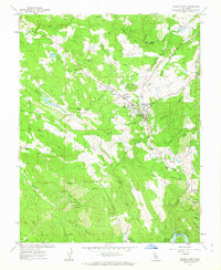
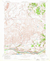
 1962 Penon Blanco Peak1963 Print · USGSMariposa and Tuolumne counties are captured in the early sixties, showing a landscape defined by gold mining history and river canyons. Genealogists and researchers can locate the Granite Spring Cemetery, the Solambo Mine, and the MERCED RIVER RAILROAD GRADE.4 unique versions available
 - 1962 Map of Keystone, 1963 Print
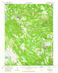
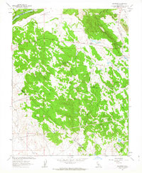 1962 Keystone1963 Print · USGSThe foothills of Tuolumne and Stanislaus Counties appear here in the early sixties as a landscape of large-scale water projects and cattle ranching. Researchers can trace the path of the Hetch Hetchy Aqueduct and locate family landmarks like the Kistler Ranch or the settlement at Keystone.2 unique versions available
 - 1962 Map of La Grange, 1963 Print
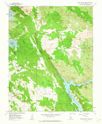
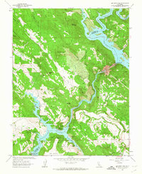
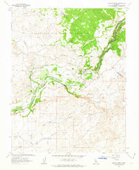
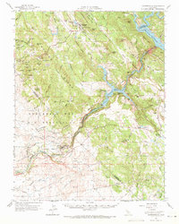
 1962 La Grange1963 Print · USGSThe Tuolumne River dominates this Sierra Nevada foothill region during the early sixties as industrial mining and water management reshape the terrain. Researchers can locate gold-era remnants like Fortynine Mine and Mitchell Mine alongside the rising waters of Don Pedro Reservoir.4 unique versions available
 - 1962 Map of Melones Dam, 1963 Print
 1962 Melones Dam1963 Print · USGSThe Stanislaus River corridor in the early sixties reveals a landscape shaped by both gold-era mining and modern reservoirs. Researchers can locate legacy sites like the Lightner Mine, the Central Ferry (Site), and the Byrne Ferry Historical Monument along the water's edge.4 unique versions available
 - 1962 Map of Knights Ferry, 1963 Print
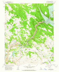
 1962 Knights Ferry1963 Print · USGSThe river canyon around Knights Ferry comes alive in the early sixties, showing the complex water systems of the Hetch Hetchy Aqueduct. Trace local history through the Sierra Railroad, the Smith Mine, and old ranch boundaries.3 unique versions available
 - 1962 Map of San Andreas, 1964 Print
 1962 San Andreas1964 Print · USGSCalaveras County is captured here in the early 1960s, a landscape defined by its Gold Country heritage and evolving water infrastructure. Genealogists and historians can trace the legacy of mining and early settlement through sites like Angels Camp, the Pioneer Cemetery, and the Cave City Mine.2 unique versions available
 - 1962 Map of Copperopolis, 1964 Print
 1962 Copperopolis1964 Print · USGSThe foothills of the Mother Lode come alive in the early sixties as mining towns and water projects reshape the landscape. Genealogists and historians can trace family-named sites like Wagner Ranch and Kistler Ranch alongside the historic Sierra Railroad and Knights Ferry crossing.2 unique versions available
 - 1962 Map of Merced Falls, 1964 Print
 1962 Merced Falls1964 Print · USGSThe California Gold Country during the early sixties reveals a landscape shaped by hydraulic mining and river power. Genealogists and historians can trace family-named sites like McNulty Ridge, locate the Don Pedro Sch, or find the Abbe Mine and Bullion Mill.
 - 1963 Map of Mariposa
 1963 Mariposa1963 Print · USGSThe High Sierra and Owens Valley meet in the early sixties, showing a landscape defined by gold-rush history and massive post-war water projects. Genealogists and researchers can trace old mining routes near Mariposa, locate the Glacier Point Hotel, and find small settlements like Coarse Gold or Knowles Junction.
 - 1964 Map of Walker Lake
 1964 Walker Lake1964 Print · USGSThe high desert and the Sierra Nevada peaks come together in the mid-1960s, showing a landscape defined by mining, military installations, and vast wilderness. Genealogists and historians can trace the remnants of old mining camps at Bodie or Candelaria and follow the Southern Pacific rail lines.2 unique versions available
 - 1966 Map of San Jose
 1966 San Jose1966 Print · USGSCentral California in the mid-1960s reveals a landscape of massive irrigation projects and expanding Cold War military footprints. Researchers can trace the rail-and-river network of the San Joaquin Valley or locate specialized sites like Castle Air Force Base and the Sharp General Depot (Military).
 - 1968 Map of Cooperstown, 1971 Print
 1968 Cooperstown1971 Print · USGSThe Sierra Nevada foothills meet the Tuolumne River in the late sixties as agricultural and rail networks define the landscape. Researchers can trace the path of the Sierra RR through Warnerville or locate historical sites like the Roberts Ferry Sch and Dredge Tailings.3 unique versions available
End of results
Showing maps 1-15 of 15
Top cities of Tuolumne County
- Sonora historical maps
- Jamestown historical maps
- Sonora Meadows historical maps
- Groveland historical maps
Frequently asked questions
- What are the different types of historical maps available for Tuolumne County?
- What is the oldest map of Tuolumne County?
- Where can I purchase historical maps of Tuolumne County for my home or office?
- Where can I download high-res historical maps of Tuolumne County?
- Are there historical topographic maps available for Tuolumne County?
- Is there historical aerial imagery available for Tuolumne County?
- Where are historical maps of Tuolumne County sourced from?