1800s (19th Century) Maps of Dolores County, Colorado
Explore 8 historic maps of Dolores County from the 1800s (19th Century). These maps offer a rare glimpse into what life looked like during the 1800s — showing old roads, neighborhoods, homes, and landmarks that have changed or disappeared over time.
Whether you're researching your family's past, planning a metal detecting trip, or studying how Dolores County's landscape evolved across the 1800s, these high-resolution maps are a powerful tool for exploring the history of this region.
- Focus on a specific era: All maps on this page are from the 1800s, giving you a focused view of this time period.
- See what’s changed: Compare century-old streets, trails, and buildings to today's modern landscape using overlays and satellite layers.
- Research with precision: Use these maps for genealogy, historical research, land use analysis, or educational projects.
- View, download, or print: Maps are fully viewable online in high resolution, and can be downloaded or printed for your own records.
Start exploring Dolores County's history through authentic maps from the 1800s. This is your window into the past.
Dolores County, CO maps
(8)- 1886 Map of Abajo
 1886 Abajo1886 Print · USGSSoutheastern Utah appears here in the late frontier era, centered on the early settlement of Bluff City along the San Juan River. Researchers can trace the path of the Old Spanish Trail or locate remote landmarks like Orejas del Oso and Abajo Peak.
 - 1892 Map of Abajo
 1892 Abajo1892 Print · USGSSoutheastern Utah in the 1890s remained a remote frontier where settlement followed the river and historic paths. Researchers can trace early routes like the Old Spanish Trail and find the riverside location of Bluff City below the Abajo Mts.
 - 1893 Map of Abajo
 1893 Abajo1893 Print · USGSSoutheastern Utah and the Colorado border are documented in the late nineteenth century during a time of early settlement and regional surveying. Researchers can trace the path of the Old Spanish Trail and locate early sites like Bluff City near the Navajo Indian Res. Line.5 unique versions available
 - 1897 Map of Rico
 1897 Rico1897 Print · USGSThe silver-mining hub of Rico is shown here in the late nineteenth century during its railroad-driven boom. Genealogists and researchers can locate family-named landmarks like Roger's Ranch and trace the winding route of the Rio Grande Southern R. R.
 - 1897 Map of Telluride
 1897 Telluride1897 Print · USGSMining and railroading define the San Miguel Mountains during the 1890s silver boom. Genealogists and historians can trace the foundations of Telluride and its surrounding camps, including Pandora, Ames (P.O.), and the Nellie Mine.
 - 1898 Map of Engineer Mountain, 1955 Print
 1898 Engineer Mountain1955 Print · USGSThe San Juan high country comes alive in this late nineteenth-century survey of the rugged terrain between Durango and Silverton. Researchers can trace early infrastructure like the Denver and Rio Grande RR, the Old Tollgate, and Hamor's Ranch.3 unique versions available
 - 1898 Map of Rico, 1957 Print
 1898 Rico1957 Print · USGSThe mining town of Rico and its surrounding peaks were a hub of activity in the late nineteenth century as the narrow-gauge railroad pushed through the mountains. Researchers can trace historic family holdings like Love's Ranch and the route of the Rio Grande Southern.
 - 1899 Map of Rico
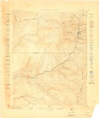 1899 Rico1899 Print · USGSThe mining town of Rico and the high San Juan peaks come into focus in the 1890s as the railroad pushes through the valley. Trace the early settlement of the West Dolores region via Waechter's Ranch, Montelores, and the winding Rio Grande Southern line.5 unique versions available
End of results
Showing maps 1-8 of 8
Top cities of Dolores County
Frequently asked questions
- What are the different types of historical maps available for Dolores County?
- What is the oldest map of Dolores County?
- Where can I purchase historical maps of Dolores County for my home or office?
- Where can I download high-res historical maps of Dolores County?
- Are there historical topographic maps available for Dolores County?
- Is there historical aerial imagery available for Dolores County?
- Where are historical maps of Dolores County sourced from?