1940s Maps of Dolores County, Colorado
Explore 3 historic maps of Dolores County from the 1940s. These maps offer a rare glimpse into what life looked like during the 1940s — showing old roads, neighborhoods, homes, and landmarks that have changed or disappeared over time.
Whether you're researching your family's past, planning a metal detecting trip, or studying how Dolores County's landscape evolved across the 1940s, these high-resolution maps are a powerful tool for exploring the history of this region.
- Focus on a specific era: All maps on this page are from the 1940s, giving you a focused view of this time period.
- See what’s changed: Compare century-old streets, trails, and buildings to today's modern landscape using overlays and satellite layers.
- Research with precision: Use these maps for genealogy, historical research, land use analysis, or educational projects.
- View, download, or print: Maps are fully viewable online in high resolution, and can be downloaded or printed for your own records.
Start exploring Dolores County's history through authentic maps from the 1940s. This is your window into the past.
Dolores County, CO maps
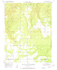
(3)- 1945 Map of Durango
 1945 Durango1945 Print · USGSSouthwest Colorado and Northern New Mexico at mid-century are defined by the high peaks of the San Juan Range and the tribal lands of the Southern Ute. Genealogists and historians can trace the paths of the D & R G W RR and locate local landmarks like Animas City and the Blanco Basin School.3 unique versions available
 - 1949 Map of Egnar
 1949 Egnar1949 Print · USGSThe mining landscape near the Colorado-Utah border is detailed in this late 1940s survey. Researchers can trace numerous early claims like the Effie B Mine and Golden Rod Mines alongside local landmarks like the Egnar School.4 unique versions available
 - 1949 Map of Joe Davis Hill, 1957 Print
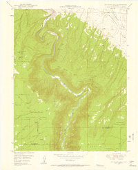 1949 Joe Davis Hill1957 Print · USGSSan Miguel and Dolores counties at the height of the mid-century uranium boom. Mineral hunters can trace the locations of the Norma Jean Mine and Mucho Grande Mine, or locate the site of Spud Patch Camp along the Dolores River.5 unique versions available
End of results
Showing maps 1-3 of 3
Top cities of Dolores County
Frequently asked questions
- What are the different types of historical maps available for Dolores County?
- What is the oldest map of Dolores County?
- Where can I purchase historical maps of Dolores County for my home or office?
- Where can I download high-res historical maps of Dolores County?
- Are there historical topographic maps available for Dolores County?
- Is there historical aerial imagery available for Dolores County?
- Where are historical maps of Dolores County sourced from?