1990s Maps of Dolores County, Colorado
Explore 16 historic maps of Dolores County from the 1990s. These maps offer a rare glimpse into what life looked like during the 1990s — showing old roads, neighborhoods, homes, and landmarks that have changed or disappeared over time.
Whether you're researching your family's past, planning a metal detecting trip, or studying how Dolores County's landscape evolved across the 1990s, these high-resolution maps are a powerful tool for exploring the history of this region.
- Focus on a specific era: All maps on this page are from the 1990s, giving you a focused view of this time period.
- See what’s changed: Compare century-old streets, trails, and buildings to today's modern landscape using overlays and satellite layers.
- Research with precision: Use these maps for genealogy, historical research, land use analysis, or educational projects.
- View, download, or print: Maps are fully viewable online in high resolution, and can be downloaded or printed for your own records.
Start exploring Dolores County's history through authentic maps from the 1990s. This is your window into the past.
Dolores County, CO maps
(16)- 1993 Map of The Glade
 1993 The Glade1993 Print · USGSThe San Juan National Forest uplands come into focus in the early nineties, revealing a complex web of remote springs and reservoirs. Researchers can trace the water-management history of the high country via Glade FS Station, Wolf Den Reservoir, and Wild Bill Spring.
 - 1993 Map of Joe Davis Hill
 1993 Joe Davis Hill1993 Print · USGSThe Dolores River corridor in San Miguel County is revealed in the early 1990s as a center for mining and remote ranching. Researchers can locate specific industrial sites like the Sarah Ellen Mine, the Spud Patch Camp (Site), and multiple upland reservoirs.
 - 1993 Map of South Mountain
 1993 South Mountain1993 Print · USGSDolores County’s high-country terrain was carefully documented in the early nineties, revealing a landscape of remote plateaus and mountain peaks. Researchers can locate Nash Cem and trace water infrastructure like the Flume and Siphon along Disappointment Creek.
 - 1993 Map of Dawson Draw
 1993 Dawson Draw1993 Print · USGSThe San Miguel and Dolores County line comes alive in the 1990s as it crosses a landscape of ranching and resource extraction. Trace the high desert geography near Daddy Williams Bridge, the Klondike mine, and a remote Cem.
 - 1993 Map of Glade Mountain
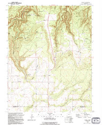
 1993 Glade Mountain1993 Print · USGSDolores County’s high forest terrain is captured in the early 1990s, showing a landscape of named springs and old pack trails. Researchers can trace remote landmarks like the Benchmark Lookout Glade, McKinney Reservoir, and the winding course of Disappointment Creek.2 unique versions available
 - 1993 Map of Willow Spring
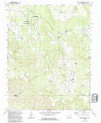
 1993 Willow Spring1993 Print · USGSDolores and Montezuma counties are shown here in the early 1990s, where high mesas meet a complex network of forest reservoirs. Local historians can trace the Old Railroad Grade or locate the Beaver Creek Massacre Historical Marker near Willow Spring.
 - 1993 Map of Narraguinnep Mountain
 1993 Narraguinnep Mountain1993 Print · USGSThe borderlands of Montezuma and Dolores Counties come into sharp focus in the early 1990s, revealing a landscape of high-country water management and mountain terrain. Researchers can locate remote landmarks like the Fort Narraguinnep Historical Site, Long Park Lake, and the winding Narraguinnep Canyon.
 - 1993 Map of Doe Canyon
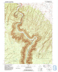
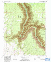
 1993 Doe Canyon1993 Print · USGSThe river canyon country of the San Juan National Forest is documented here in the early 1990s. Researchers can trace land use patterns through landmarks like Bradfield Bridge, the Dolores River State Wildlife Area, and the numerous reservoirs including Arnold Reservoir and McClure Reservoir.
 - 1993 Map of Secret Canyon
 1993 Secret Canyon1993 Print · USGSThe Dolores River gorge and the surrounding San Juan National Forest are captured here in the early nineties, revealing a landscape of deep canyons and high points. Researchers can trace remote water sources and infrastructure such as Tommy Spring, Baird Reservoir, and the Dove Creek Pumping Sta.
 - 1993 Map of Champagne Spring, 1994 Print
 1993 Champagne Spring1994 Print · USGSHigh desert plateaus meet deep canyon drainages at the Dolores and Montezuma county line during the early nineties. Researchers can trace resource development from the Oil Field gas wells to water infrastructure like the Dove Cr Canal and Champagne Spring.
 - 1994 Map of Mc Kenna Peak
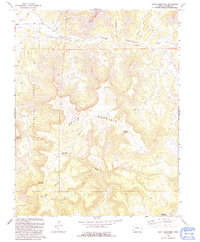
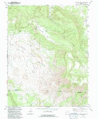 1994 Mc Kenna Peak1994 Print · USGSSouthwestern Colorado ranching and desert landscapes are captured here in the mid-nineties. Researchers can trace historic family-named sites like the Bassnet Homestead and landmark peaks such as McKenna Peak and Brumley Point.
 - 1994 Map of Cahone
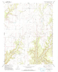
 1994 Cahone1994 Print · USGSThe settlement of Cahone is captured in the mid-nineties as a junction of rural community life and complex water engineering. Researchers can trace land use through features like the P O, the town Cem, and the extensive Dove Creek Siphon network.
 - 1994 Map of Ruin Canyon
 1994 Ruin Canyon1994 Print · USGSMontezuma County in the mid-nineties is documented here as a landscape of ancient ruins and modern energy extraction. Researchers can locate remote burial sites at Sylvan Cem, trace deep drainages like Hovenweep Canyon, and explore the area surrounding Lowry Ruins.
 - 1994 Map of Dove Creek
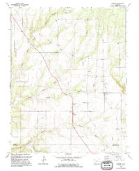
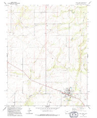 1994 Dove Creek1994 Print · USGSDove Creek and its high desert surroundings are captured here in the mid-1990s, showcasing the area's agricultural and transportation infrastructure. Researchers can locate family names and sites such as Peel Cem, the Municipal Airport, and the branching West Monument Creek.
 - 1994 Map of Egnar
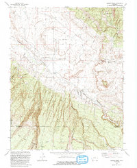
 1994 Egnar1994 Print · USGSSan Miguel County, Colorado, in the early nineties is a landscape shaped by uranium exploration and canyon-cut terrain. Researchers can trace the industrial footprint of the Department of Energy Uranium Reserve and locate local landmarks such as Egnar, the Strawberry Roan Mine, and Summit Point.
 - 1994 Map of North Mountain
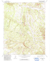
 1994 North Mountain1994 Print · USGSThe high mesas of San Miguel and Dolores counties are captured here in the early nineties, showing a landscape defined by ranching and remote transit. Researchers can trace the Old Salt Grade Road or locate family-named sites like Jensens Cow Camp and Nellies Flats.
End of results
Showing maps 1-16 of 16
Top cities of Dolores County
Frequently asked questions
- What are the different types of historical maps available for Dolores County?
- What is the oldest map of Dolores County?
- Where can I purchase historical maps of Dolores County for my home or office?
- Where can I download high-res historical maps of Dolores County?
- Are there historical topographic maps available for Dolores County?
- Is there historical aerial imagery available for Dolores County?
- Where are historical maps of Dolores County sourced from?