1940s Maps of Fremont County, Colorado
Explore 8 historic maps of Fremont County from the 1940s. These maps offer a rare glimpse into what life looked like during the 1940s — showing old roads, neighborhoods, homes, and landmarks that have changed or disappeared over time.
Whether you're researching your family's past, planning a metal detecting trip, or studying how Fremont County's landscape evolved across the 1940s, these high-resolution maps are a powerful tool for exploring the history of this region.
- Focus on a specific era: All maps on this page are from the 1940s, giving you a focused view of this time period.
- See what’s changed: Compare century-old streets, trails, and buildings to today's modern landscape using overlays and satellite layers.
- Research with precision: Use these maps for genealogy, historical research, land use analysis, or educational projects.
- View, download, or print: Maps are fully viewable online in high resolution, and can be downloaded or printed for your own records.
Start exploring Fremont County's history through authentic maps from the 1940s. This is your window into the past.
Fremont County, CO maps
(8)- 1942 Map of Colorado Springs
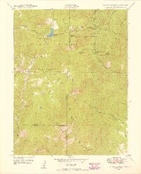
 1942 Colorado Springs1942 Print · USGSColorado Springs and the Front Range appear here in the early years of the Second World War. Genealogists and historians can trace the rail corridors of the Chicago Rock Island and Pacific RR and locate sites like the Printers Home and Glen Eyrie.
 - 1942 Map of Cover Mtn., 1972 Print
 1942 Cover Mtn.1972 Print · USGSHigh mountain ranching and feldspar mining dominate this Fremont County landscape during the early 1940s. Genealogists and historians can trace family-named sites like F L Rowe Ranch and Stahl Ranch, alongside rural landmarks like the Twelvemile Sch.
 - 1948 Map of Cover Mtn.
 1948 Cover Mtn.1948 Print · USGSFremont and Park Counties at the close of the 1940s show a high-altitude ranching and mining landscape defined by the Colorado Feldspar Company Mine. Genealogists can trace legacy holdings like the Nash Ranch or locate local landmarks like the Twelvemile Sch and Wilson Creek Sch.3 unique versions available
 - 1948 Map of Mount Big Chief, 1953 Print
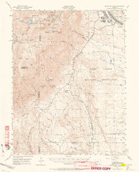
 1948 Mount Big Chief1953 Print · USGSThe Front Range high country comes alive in this post-war survey of the mountains southwest of Colorado Springs. Researchers can trace historic mountain retreats and outposts like Broadmoor Lodge, Rosemont, and the Emerald Valley Boys Camp.2 unique versions available
 - 1948 Map of Mount Pittsburg, 1956 Print
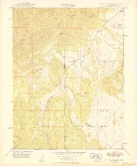
 1948 Mount Pittsburg1956 Print · USGSSouthern Colorado ranching country is captured here just after the war, showing the foothills at the convergence of three counties. Local historians can locate early family-named sites like Fords Mountaindale Ranch and the Red Creek School.
 - 1948 Map of Mount Big Chief, 1964 Print
 1948 Mount Big Chief1964 Print · USGSThe foothills and high peaks of the Front Range come alive in this post-war study of the area south of Colorado Springs. Genealogists and historians can trace the foundations of Camp Carson, search for family-named holdings like Avery Ranch, or locate vanished mountain schools such as Lytle School.2 unique versions available
 - 1949 Map of Mount Big Chief
 1949 Mount Big Chief1949 Print · USGSThe high peaks and ranch lands of El Paso County are captured here in the late Forties, a period of established mountain retreats. Researchers can trace historic access routes like Gold Camp Road to reach Broadmoor Lodge, Pecks Camp, and the Emerald Valley Ranch.
 - 1949 Map of Mount Pittsburg
 1949 Mount Pittsburg1949 Print · USGSThe high ranching country of southern Colorado is documented here in the late 1940s at the junction of three counties. Genealogists and historians can trace family-held lands like Fords Mountaindale Ranch and the site of the Red Creek School.2 unique versions available
End of results
Showing maps 1-8 of 8
Top cities of Fremont County
- Cañon City historical maps
- Lincoln Park historical maps
- Florence historical maps
- Penrose historical maps
- Howard historical maps
- Williamsburg historical maps
See more
Frequently asked questions
- What are the different types of historical maps available for Fremont County?
- What is the oldest map of Fremont County?
- Where can I purchase historical maps of Fremont County for my home or office?
- Where can I download high-res historical maps of Fremont County?
- Are there historical topographic maps available for Fremont County?
- Is there historical aerial imagery available for Fremont County?
- Where are historical maps of Fremont County sourced from?