1960s Maps of Fremont County, Colorado
Explore 8 historic maps of Fremont County from the 1960s. These maps offer a rare glimpse into what life looked like during the 1960s — showing old roads, neighborhoods, homes, and landmarks that have changed or disappeared over time.
Whether you're researching your family's past, planning a metal detecting trip, or studying how Fremont County's landscape evolved across the 1960s, these high-resolution maps are a powerful tool for exploring the history of this region.
- Focus on a specific era: All maps on this page are from the 1960s, giving you a focused view of this time period.
- See what’s changed: Compare century-old streets, trails, and buildings to today's modern landscape using overlays and satellite layers.
- Research with precision: Use these maps for genealogy, historical research, land use analysis, or educational projects.
- View, download, or print: Maps are fully viewable online in high resolution, and can be downloaded or printed for your own records.
Start exploring Fremont County's history through authentic maps from the 1960s. This is your window into the past.
Fremont County, CO maps
(8)- 1960 Map of Montrose
 1960 Montrose1960 Print · USGSThe Colorado high country in the mid-fifties is captured here during a period of steady ranching and persistent mining. Researchers can trace the path of the Denver & Rio Grande Western RR or locate small settlements like Somerset, Maher, and Sargent.2 unique versions available
 - 1961 Map of Mount Big Chief, 1963 Print
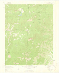 1961 Mount Big Chief1963 Print · USGSEl Paso and Teller counties in the early 1960s reveal a landscape of high-altitude ranching and forest recreation. Trace the historic Gold Camp Road past Rosemont or locate the site of the Emerald Valley Boys Camp and Broadmoor Lodge.6 unique versions available
 - 1961 Map of Mount Pittsburg, 1963 Print
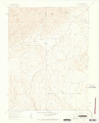 1961 Mount Pittsburg1963 Print · USGSThe high ranch lands of Fremont and El Paso counties are captured here in the early sixties, showing a landscape of remote mountain holdings and steep canyons. Genealogists and local historians can trace legacy properties like Foote Mountaindale Ranch or locate the old Quarries and the Landing Strip near Turkey Creek.8 unique versions available
 - 1962 Map of Pueblo
 1962 Pueblo1962 Print · USGSThe Front Range and high plains meet in the early sixties as military installations and industrial mining shape the corridor from Colorado Springs to Pueblo. Genealogists can trace family names through rural landmarks like the Columbine School, Hanover Church, and Fairview Cem.
 - 1963 Map of Pierce Gulch, 1965 Print
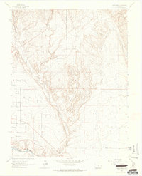 1963 Pierce Gulch1965 Print · USGSFremont and Pueblo counties in the early sixties are defined by the convergence of mountain drainages and vital rail lines. Genealogists and researchers can trace the path of the Denver and Rio Grande Western railroad as it follows the Arkansas River near Booth Mountain.6 unique versions available
 - 1963 Map of Hobson, 1965 Print
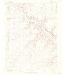 1963 Hobson1965 Print · USGSThe Arkansas River valley comes into sharp focus during the early sixties, showing the vital intersection of rail and irrigation in this high-plains landscape. Researchers can trace the paths of the Denver and Rio Grande Western railroad and the Minnequa Canal past Hobson and Siloam.4 unique versions available
 - 1966 Map of Pueblo
 1966 Pueblo1966 Print · USGSThe Front Range and Arkansas River Valley are captured here in the mid-1960s, showing a landscape shaped by mining, military expansion, and rail. Researchers can locate numerous country schools and mines, such as the Lytle School, Pioneer Cem, and Empire Zinc Mine.
 - 1968 Map of Montrose
 1968 Montrose1968 Print · USGSThe Western Slope and Continental Divide meet in the late sixties, showing the vital river valleys and high-mountain mining districts. Trace the historic route of the Denver and Rio Grande Western RR or locate small settlements like Sargents and Powderhorn.
End of results
Showing maps 1-8 of 8
Top cities of Fremont County
- Cañon City historical maps
- Lincoln Park historical maps
- Florence historical maps
- Penrose historical maps
- Howard historical maps
- Williamsburg historical maps
See more
Frequently asked questions
- What are the different types of historical maps available for Fremont County?
- What is the oldest map of Fremont County?
- Where can I purchase historical maps of Fremont County for my home or office?
- Where can I download high-res historical maps of Fremont County?
- Are there historical topographic maps available for Fremont County?
- Is there historical aerial imagery available for Fremont County?
- Where are historical maps of Fremont County sourced from?