Old Maps of Fremont County, Colorado for Hiking & Exploration
Hike through history with 278 historic maps of Fremont County. Explore old trails, ghost towns, and forgotten backroads — perfect for outdoor adventurers and local explorers.
- Rediscover forgotten places: Map out old mining camps, roads, and footpaths that no longer exist on modern maps.
- Layer with modern tools: Combine with LiDAR or satellite views to plan hikes through historical terrain.
- Made for exploration: Popular among hikers, overlanders, and local history lovers.
Use these maps to find adventure and explore the hidden past of Fremont County.
Fremont County, CO maps
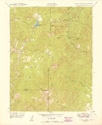
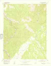
(278)- 1889 Map of Canon City
 1889 Canon City1889 Print · USGSFremont and Custer counties appear here during the peak of the Colorado silver boom, when mining and rail expansion transformed the valley. Genealogists can trace family roots in early settlements like Silver Cliff, Rosita, and the coal camps of Rockvale.2 unique versions available
 - 1891 Map of Pueblo
 1891 Pueblo1891 Print · USGSPueblo and the Arkansas River valley are shown here in the late nineteenth century as the region's rail and industrial power surged. Local historians can trace the early footprints of Bessemer, the extensive rail yards of the Missouri Pacific Railroad, and rural landmarks like the Three R Ranch.
 - 1892 Map of Canon City
 1892 Canon City1892 Print · USGSThe mining camps of Custer and Fremont counties were in their prime during the 1890s silver and coal boom. Genealogists and historians can trace the early rail networks and locate hard-rock operations like the Bassick Mine or settlements such as Silver Cliff and Querida.8 unique versions available
 - 1893 Map of Colorado Springs, 1896 Print
 1893 Colorado Springs1896 Print · USGSEl Paso County at the end of the nineteenth century was a booming intersection of mountain tourism and heavy rail commerce. Researchers can trace early railroad alignments like the Colorado Midland Railroad and locate vanished stops at Franceville Junction or Bierstadt.2 unique versions available
 - 1894 Map of Pikes Peak
 1894 Pikes Peak1894 Print · USGSThe Cripple Creek mining district is in its golden prime in the 1890s, caught here just as the mountain rail network was expanding. Researchers can trace early mining camps like Barry and Alnwick or locate the original path of the Colorado Midland Railroad through Florissant.2 unique versions available
 - 1894 Map of Pueblo, 1957 Print
 1894 Pueblo1957 Print · USGSPueblo and the Arkansas River valley are captured here at a pivotal moment of late-century industrial growth. Researchers can trace early rail corridors and vanished rural landmarks like Three R Ranch, Bessemer Junction, and Glendale.2 unique versions available
 - 1896 Map of Pueblo
 1896 Pueblo1896 Print · USGSPueblo and its surrounding mesas are shown here in the 1890s as a thriving rail and irrigation hub. Genealogists and historians can trace the early layouts of Bessemer Junction, follow the Trinidad Line, or locate the family-owned Three R Ranch near the Hogback Mt.
 - 1897 Map of Pueblo
 1897 Pueblo1897 Print · USGSPueblo and its surrounding plains were a bustling railroad and industrial crossroads in the late nineteenth century. Genealogists and historians can trace the early footprints of Bessemer Junction, the intricate Bessemer Ditch, and family landmarks like the Three R Ranch.4 unique versions available
 - 1901 Map of Pikes Peak
 1901 Pikes Peak1901 Print · USGSThe Cripple Creek mining district is in its golden age on this turn-of-the-century sheet. Genealogists and historians can trace the rail lines and mountain camps that defined the rush, from Victor and Goldfield to the Fossil Beds at Florissant.6 unique versions available
 - 1909 Map of Colorado Springs
 1909 Colorado Springs1909 Print · USGSColorado Springs and the Front Range foothills are shown here at a pivotal era of rail expansion and early tourism. Genealogists and historians can trace defunct rail lines, rural schoolhouse locations like Grandview School, and landmarks such as the Cliff Dwellings and Burial Rocks.5 unique versions available
 - 1942 Map of Colorado Springs
 1942 Colorado Springs1942 Print · USGSColorado Springs and the Front Range appear here in the early years of the Second World War. Genealogists and historians can trace the rail corridors of the Chicago Rock Island and Pacific RR and locate sites like the Printers Home and Glen Eyrie.
 - 1942 Map of Cover Mtn., 1972 Print
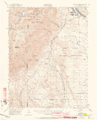
 1942 Cover Mtn.1972 Print · USGSHigh mountain ranching and feldspar mining dominate this Fremont County landscape during the early 1940s. Genealogists and historians can trace family-named sites like F L Rowe Ranch and Stahl Ranch, alongside rural landmarks like the Twelvemile Sch.
 - 1948 Map of Cover Mtn.
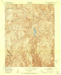
 1948 Cover Mtn.1948 Print · USGSFremont and Park Counties at the close of the 1940s show a high-altitude ranching and mining landscape defined by the Colorado Feldspar Company Mine. Genealogists can trace legacy holdings like the Nash Ranch or locate local landmarks like the Twelvemile Sch and Wilson Creek Sch.3 unique versions available
 - 1948 Map of Mount Big Chief, 1953 Print
 1948 Mount Big Chief1953 Print · USGSThe Front Range high country comes alive in this post-war survey of the mountains southwest of Colorado Springs. Researchers can trace historic mountain retreats and outposts like Broadmoor Lodge, Rosemont, and the Emerald Valley Boys Camp.2 unique versions available
 - 1948 Map of Mount Pittsburg, 1956 Print
 1948 Mount Pittsburg1956 Print · USGSSouthern Colorado ranching country is captured here just after the war, showing the foothills at the convergence of three counties. Local historians can locate early family-named sites like Fords Mountaindale Ranch and the Red Creek School.
 - 1948 Map of Mount Big Chief, 1964 Print
 1948 Mount Big Chief1964 Print · USGSThe foothills and high peaks of the Front Range come alive in this post-war study of the area south of Colorado Springs. Genealogists and historians can trace the foundations of Camp Carson, search for family-named holdings like Avery Ranch, or locate vanished mountain schools such as Lytle School.2 unique versions available
 - 1949 Map of Mount Big Chief
 1949 Mount Big Chief1949 Print · USGSThe high peaks and ranch lands of El Paso County are captured here in the late Forties, a period of established mountain retreats. Researchers can trace historic access routes like Gold Camp Road to reach Broadmoor Lodge, Pecks Camp, and the Emerald Valley Ranch.
 - 1949 Map of Mount Pittsburg
 1949 Mount Pittsburg1949 Print · USGSThe high ranching country of southern Colorado is documented here in the late 1940s at the junction of three counties. Genealogists and historians can trace family-held lands like Fords Mountaindale Ranch and the site of the Red Creek School.2 unique versions available
 - 1951 Map of Mount Big Chief
 1951 Mount Big Chief1951 Print · USGSEl Paso and Fremont counties were undergoing a significant military expansion in the early fifties as CAMP CARSON grew into the mountains. Researchers can trace family ranching history at Turkey Creek Ranch or locate vanished rural education sites like Lytle School.2 unique versions available
 - 1951 Map of Cripple Creek South, 1954 Print
 1951 Cripple Creek South1954 Print · USGSThe Cripple Creek mining district shows its mid-century industrial footprint in this 1950s survey. Researchers can trace the extensive network of mines and shafts like the Cresson Mine and Elkton Mine, or locate family sites in Victor and Altman.9 unique versions available
 - 1951 Map of Big Bull Mountain, 1954 Print
 1951 Big Bull Mountain1954 Print · USGSHigh-altitude mining and power infrastructure define the Teller County backcountry in the early fifties. Researchers can trace the path of the Narrow Gauge RR through Phantom Canyon and locate the Mining Area near Goldfield.8 unique versions available
 - 1954 Map of Phantom Canyon, 1955 Print
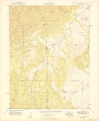
 1954 Phantom Canyon1955 Print · USGSFremont County’s mountain terrain comes into focus in the mid-1950s, showing a landscape of remote cabins and rugged ranching outposts. Genealogists and historians can locate the Upper Beaver School, Upper Beaver Cem, and the settlement at Adelaide.4 unique versions available
 - 1954 Map of Cooper Mountain, 1955 Print
 1954 Cooper Mountain1955 Print · USGSFremont County ranching and scientific history meet in the mid-1950s near the Garden Park Dinosaur Monument. Researchers can trace old mountain outposts and water infrastructure through sites like Dilley Ranch, the Garden Park Sch, and the University of Kansas Geology Summer Camp.3 unique versions available
 - 1954 Map of Pueblo, 1966 Print
 1954 Pueblo1966 Print · USGSMid-century Colorado comes alive in this survey of the Front Range and the high plains as the region expanded after the war. Genealogists and historians can trace family roots through rural landmarks like Hanover Church, Pioneer Cemetery, and the Grandview School.3 unique versions available
 - 1956 Map of Cameron Mountain, 1959 Print
 1956 Cameron Mountain1959 Print · USGSThe Arkansas River valley near Salida and Cleora is shown here in the mid-fifties as the local mining and rail economy thrived. Researchers can trace the DENVER AND RIO GRANDE WESTERN line, the remote Oklahoma A & M Engineering Camp, and the Golden Wonder Mine.4 unique versions available
Showing maps 1-25 of 278
Top cities of Fremont County
- Cañon City historical maps
- Lincoln Park historical maps
- Florence historical maps
- Penrose historical maps
- Howard historical maps
- Williamsburg historical maps
See more
Frequently asked questions
- What are the different types of historical maps available for Fremont County?
- What is the oldest map of Fremont County?
- Where can I purchase historical maps of Fremont County for my home or office?
- Where can I download high-res historical maps of Fremont County?
- Are there historical topographic maps available for Fremont County?
- Is there historical aerial imagery available for Fremont County?
- Where are historical maps of Fremont County sourced from?