1920s Maps of Grand County, Colorado
Explore 5 historic maps of Grand County from the 1920s. These maps offer a rare glimpse into what life looked like during the 1920s — showing old roads, neighborhoods, homes, and landmarks that have changed or disappeared over time.
Whether you're researching your family's past, planning a metal detecting trip, or studying how Grand County's landscape evolved across the 1920s, these high-resolution maps are a powerful tool for exploring the history of this region.
- Focus on a specific era: All maps on this page are from the 1920s, giving you a focused view of this time period.
- See what’s changed: Compare century-old streets, trails, and buildings to today's modern landscape using overlays and satellite layers.
- Research with precision: Use these maps for genealogy, historical research, land use analysis, or educational projects.
- View, download, or print: Maps are fully viewable online in high resolution, and can be downloaded or printed for your own records.
Start exploring Grand County's history through authentic maps from the 1920s. This is your window into the past.
Grand County, CO maps
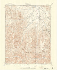
(5)- 1924 Map of Montezuma
 1924 Montezuma1924 Print · USGSHigh Colorado peaks and mining camps define the landscape during the 1920s and 1930s. Genealogists and historians can trace the foundations of Montezuma and Keystone, and locate historic operations like the Hamill Mine and Waldorf Mine.2 unique versions available
 - 1924 Map of Fraser, 1957 Print
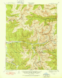
 1924 Fraser1957 Print · USGSGrand County's high-country rail and ranching corridors come alive in this mid-twenties survey of the Fraser Valley. Researchers can trace the original Denver and Salt Lake RR route, locate the Pole Creek School, and study the early layout of West Portal near the Moffat Tunnel.2 unique versions available
 - 1926 Map of Fraser
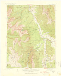
 1926 Fraser1926 Print · USGSThe high Rockies come alive in the mid-twenties as the Moffat Tunnel and Denver and Salt Lake Railroad reshape the landscape. Researchers can trace early infrastructure like the Lumber Flume and the isolated Pole Creek School.4 unique versions available
 - 1926 Map of Montezuma
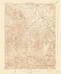
 1926 Montezuma1926 Print · USGSThe Continental Divide during the 1920s reveals a high-country landscape defined by its mining heritage and high mountain passes. Researchers can trace the rugged operations at the Waldorf Mine and Stevens Mine or locate the early mountain settlements of Montezuma and Swandyke.3 unique versions available
 - 1929 Map of Dillon, 1955 Print
 1929 Dillon1955 Print · USGSIn the late 1920s, the Blue River valley was a high-country network of rail stops and mining camps before the landscape was changed by major dam projects. Genealogists and historians can trace the early footprints of Dillon, Frisco, and the Colorado and Southern railroad line.2 unique versions available
End of results
Showing maps 1-5 of 5
Top cities of Grand County
- Granby historical maps
- Kremmling historical maps
- Fraser historical maps
- Hot Sulphur Springs historical maps
- Grand Lake historical maps
- Tabernash historical maps
Frequently asked questions
- What are the different types of historical maps available for Grand County?
- What is the oldest map of Grand County?
- Where can I purchase historical maps of Grand County for my home or office?
- Where can I download high-res historical maps of Grand County?
- Are there historical topographic maps available for Grand County?
- Is there historical aerial imagery available for Grand County?
- Where are historical maps of Grand County sourced from?