Old Maps of Whitepine, Colorado for Hiking & Exploration
Hike through history with 14 historic maps of Whitepine. Explore old trails, ghost towns, and forgotten backroads — perfect for outdoor adventurers and local explorers.
- Rediscover forgotten places: Map out old mining camps, roads, and footpaths that no longer exist on modern maps.
- Layer with modern tools: Combine with LiDAR or satellite views to plan hikes through historical terrain.
- Made for exploration: Popular among hikers, overlanders, and local history lovers.
Use these maps to find adventure and explore the hidden past of Whitepine.
Whitepine, CO maps
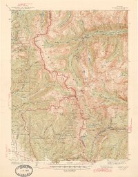
(14)- 1940 Map of Garfield, 1954 Print
 1940 Garfield1954 Print · USGSThe high Sawatch Range is seen here at the peak of its industrial mining era, straddling the Continental Divide. Genealogists and historians can trace defunct mountain rail routes and remote settlements like St Elmo, Hancock, and the historic Old Alpine Tunnel.6 unique versions available
 - 1945 Map of Garfield
 1945 Garfield1945 Print · USGSThe high Sawatch Range and its historic mining districts appear here in the mid-1940s, just as many remote camps were reaching a quiet maturity. Genealogists and historians can trace the steep paths to St Elmo, the OLD ALPINE TUNNEL, and active sites like the GARFIELD MINE.2 unique versions available
 - 1956 Map of Montrose, 1963 Print
 1956 Montrose1963 Print · USGSThe Colorado western slope in the late fifties and early sixties shows a landscape defined by the Denver & Rio Grande Western RR and the Gunnison River. Trace the development of Blue Mesa Reservoir or locate high-country sites like the Bachelor Mine.3 unique versions available
 - 1959 Map of Montrose
 1959 Montrose1959 Print · USGSWestern Colorado in the late fifties is defined by the high peaks and river valleys of the Southern Rockies. Genealogists and historians can trace the paths of the Denver & Rio Grande Western RR or locate mountain settlements like Crawford, Lazear, and Doyleville.
 - 1960 Map of Montrose
 1960 Montrose1960 Print · USGSThe Colorado high country in the mid-fifties is captured here during a period of steady ranching and persistent mining. Researchers can trace the path of the Denver & Rio Grande Western RR or locate small settlements like Somerset, Maher, and Sargent.2 unique versions available
 - 1968 Map of Montrose
 1968 Montrose1968 Print · USGSThe Western Slope and Continental Divide meet in the late sixties, showing the vital river valleys and high-mountain mining districts. Trace the historic route of the Denver and Rio Grande Western RR or locate small settlements like Sargents and Powderhorn.
 - 1982 Map of Whitepine, 1983 Print
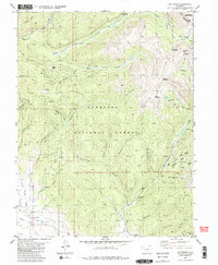 1982 Whitepine1983 Print · USGSGunnison County mining history is preserved here during the early 1980s, centered on the high-altitude camps and peaks of the Sawatch Range. Genealogists and industrial historians can trace the foundations of Whitepine, locate the Akron Mine, and find the local Cem near the banks of Tomichi Creek.2 unique versions available
 - 1984 Map of Gunnison
 1984 Gunnison1984 Print · USGSHigh mountain passes and historic mining districts define this mid-eighties record of the central Colorado Rockies. Genealogists and historians can trace the foundations of Gunnison and Crested Butte or locate remote sites like St Elmo, Tincup, and Hancock.2 unique versions available
 - 2001 Map of Whitepine, 2004 Print
 2001 Whitepine2004 Print · USGSHigh-altitude mining camps and mountain passes define this Gunnison County landscape at the start of the twenty-first century. Genealogists and researchers can trace the history of Whitepine and Eldorado while locating the North Star Mine and local Cem.
 - 2011 Map of Whitepine, 2011 Print
 2011 Whitepine2011 Print · USGSCovers Whitepine, including Chaffee County, Gunnison County, and other nearby areas
 - 2013 Map of Whitepine, 2013 Print
 2013 Whitepine2013 Print · USGSCovers Whitepine, including Chaffee County, Gunnison County, and other nearby areas
 - 2016 Map of Whitepine, 2016 Print
 2016 Whitepine2016 Print · USGSCovers Whitepine, including Chaffee County, Gunnison County, and other nearby areas
 - 2019 Map of Whitepine, 2019 Print
 2019 Whitepine2019 Print · USGSCovers Whitepine, including Chaffee County, Gunnison County, and other nearby areas
 - 2022 Map of Whitepine, 2022 Print
 2022 Whitepine2022 Print · USGSThe Sawatch Range near the Gunnison and Chaffee county line was a hive of alpine activity long before modern recreation took hold. Genealogists and researchers can trace the footprint of Whitepine, visit the White Pine Cem, and explore old high-country routes like Tomichi Pass and the Waunita Trl.
End of results
Showing maps 1-14 of 14
Top cities near Whitepine
Frequently asked questions
- What are the different types of historical maps available for Whitepine?
- What is the oldest map of Whitepine?
- Where can I purchase historical maps of Whitepine for my home or office?
- Where can I download high-res historical maps of Whitepine?
- Are there historical topographic maps available for Whitepine?
- Is there historical aerial imagery available for Whitepine?
- Where are historical maps of Whitepine sourced from?