1900-1909 Maps of Park County, Colorado
Explore 3 historic maps of Park County from 1900-1909. These maps offer a rare glimpse into what life looked like during the 1900s — showing old roads, neighborhoods, homes, and landmarks that have changed or disappeared over time.
Whether you're researching your family's past, planning a metal detecting trip, or studying how Park County's landscape evolved across the 1900s, these high-resolution maps are a powerful tool for exploring the history of this region.
- Focus on a specific era: All maps on this page are from the 1900s, giving you a focused view of this time period.
- See what’s changed: Compare century-old streets, trails, and buildings to today's modern landscape using overlays and satellite layers.
- Research with precision: Use these maps for genealogy, historical research, land use analysis, or educational projects.
- View, download, or print: Maps are fully viewable online in high resolution, and can be downloaded or printed for your own records.
Start exploring Park County's history through authentic maps from the 1900s. This is your window into the past.
Park County, CO maps
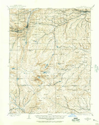
(3)- 1901 Map of Pikes Peak
 1901 Pikes Peak1901 Print · USGSThe Cripple Creek mining district is in its golden age on this turn-of-the-century sheet. Genealogists and historians can trace the rail lines and mountain camps that defined the rush, from Victor and Goldfield to the Fossil Beds at Florissant.6 unique versions available
 - 1903 Map of Georgetown, 1957 Print
 1903 Georgetown1957 Print · USGSMining operations and mountain railroads define the Clear Creek valley at the dawn of the twentieth century. Trace the iconic Georgetown Loop railroad and locate historic mining centers like Silver Plume, Lamartine, and the Stanley Mines.
 - 1905 Map of Georgetown
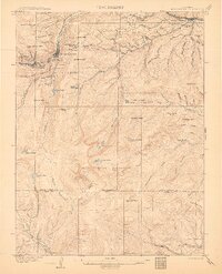 1905 Georgetown1905 Print · USGSThe Clear Creek valley was a hive of industrial activity at the start of the twentieth century, anchored by the rail connection between Georgetown and Silver Plume. Trace the famous Georgetown Loop and find high-altitude mining sites at Lamartine and Freeland.5 unique versions available
End of results
Showing maps 1-3 of 3
Top cities of Park County
Frequently asked questions
- What are the different types of historical maps available for Park County?
- What is the oldest map of Park County?
- Where can I purchase historical maps of Park County for my home or office?
- Where can I download high-res historical maps of Park County?
- Are there historical topographic maps available for Park County?
- Is there historical aerial imagery available for Park County?
- Where are historical maps of Park County sourced from?