1990s Maps of Park County, Colorado
Explore 41 historic maps of Park County from the 1990s. These maps offer a rare glimpse into what life looked like during the 1990s — showing old roads, neighborhoods, homes, and landmarks that have changed or disappeared over time.
Whether you're researching your family's past, planning a metal detecting trip, or studying how Park County's landscape evolved across the 1990s, these high-resolution maps are a powerful tool for exploring the history of this region.
- Focus on a specific era: All maps on this page are from the 1990s, giving you a focused view of this time period.
- See what’s changed: Compare century-old streets, trails, and buildings to today's modern landscape using overlays and satellite layers.
- Research with precision: Use these maps for genealogy, historical research, land use analysis, or educational projects.
- View, download, or print: Maps are fully viewable online in high resolution, and can be downloaded or printed for your own records.
Start exploring Park County's history through authentic maps from the 1990s. This is your window into the past.
Park County, CO maps
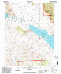
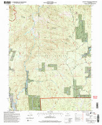
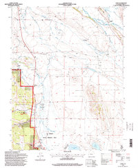
(41)- 1994 Map of Antero Reservoir, 1997 Print
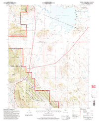 1994 Antero Reservoir1997 Print · USGSHigh-mountain ranching and water engineering define this South Park landscape during the mid-nineties. Researchers can trace the Old Railroad Grade and locate old homesteads like the Salt Works Ranch or the Haver (Aband) settlement site.3 unique versions available
 - 1994 Map of Jones Hill, 1997 Print
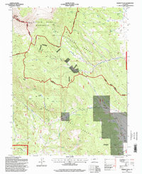
 1994 Jones Hill1997 Print · USGSThe high Colorado backcountry of Park County is captured in the mid-nineties during a period of wilderness expansion. Trace the borders of the Buffalo Peaks Wilderness and find landmarks like Twelvemile Club and Weston Pass Ranch.2 unique versions available
 - 1994 Map of Black Mountain, 1997 Print
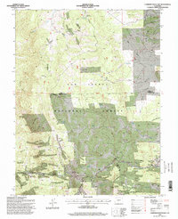
 1994 Black Mountain1997 Print · USGSThe high ranchlands and forest boundaries of Fremont and Park counties are detailed here during the mid-nineties. Researchers can locate remote sites like Stirrup Ranch, various mountain prospects, and the drainage of Cottonwood Creek.2 unique versions available
 - 1994 Map of Shawnee, 1998 Print
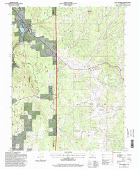
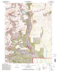
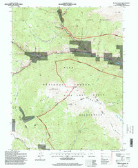
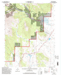
 1994 Shawnee1998 Print · USGSThe South Fork Platte River valley in the 1990s remains the heart of this high-country corridor. Researchers can trace the layout of Shawnee and Glenisle, alongside mountain landmarks like Crooked Top Mountain and the Ben Tyler Trail.
 - 1994 Map of Lake George, 1998 Print
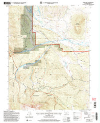
 1994 Lake George1998 Print · USGSThe South Platte River valley and the fossil-rich lands of Teller County appear here in the mid-1990s. Trace the roads through Florissant, explore the boundaries of Florissant Fossil Beds National Monument, or find Camp Alexander near Blue Mountain.2 unique versions available
 - 1994 Map of Eagle Rock, 1998 Print
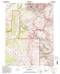
 1994 Eagle Rock1998 Print · USGSPark County high country in the mid-nineties shows a landscape defined by the Pike National Forest and critical water infrastructure. You can trace early ranching roots at Paige Ranch, locate the Elkhorn Aqueduct, and follow the Ouray Trail through the gulches.2 unique versions available
 - 1994 Map of Wrights Reservoir, 1998 Print
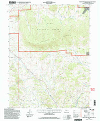
 1994 Wrights Reservoir1998 Print · USGSThe Pike National Forest and the Park-Teller county line define this Colorado landscape in the mid-1990s. Genealogists and researchers can locate the Fourmile Ch and Fourmile Cem or trace drainages like West Fourmile Creek.
 - 1994 Map of Dicks Peak, 1998 Print
 1994 Dicks Peak1998 Print · USGSPark County highlands in the mid-nineties reveal a landscape defined by mountain peaks and deep alpine gulches within the Pike National Forest. Trace the drainage patterns of Buffalo Gulch and Wagon Tongue Creek or locate the high-elevation Currant Creek Pass.2 unique versions available
 - 1994 Map of Alma, 1998 Print
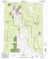
 1994 Alma1998 Print · USGSThe high peaks of the Tenmile and Mosquito Ranges come alive in the mid-1990s as this map traces the deep mining history of the South Platte headwaters. Researchers can locate active and former operations like the Sweet Home Mine and Magnolia Mill, or find family names at the Park City Cem.
 - 1994 Map of Fairplay West, 1998 Print
 1994 Fairplay West1998 Print · USGSPark County high country comes into focus in the 1990s as a landscape of former mining camps and timber operations. Genealogists and historians can trace the foundations of Sacramento, the Duquesne Smelter, and the Almgren Tie Camp.
 - 1994 Map of South Peak, 1998 Print
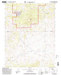
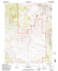
 1994 South Peak1998 Print · USGSPark County high country is shown in detail during the mid-1990s, where three counties meet among protected wilderness and national forest lands. Researchers can trace historic alpine routes like Weston Pass and locate high-altitude prospects near Black Mountain.2 unique versions available
 - 1994 Map of Sulphur Mountain, 1998 Print
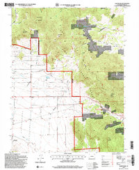
 1994 Sulphur Mountain1998 Print · USGSPark County ranching and water history come into focus in the 1990s as irrigation networks trace the South Platte basin. Genealogists and historians can locate family holdings like Buckley Ranch and Spinney Ranch alongside Pike-San Isabel Village.
 - 1994 Map of Mount Logan, 1998 Print
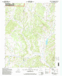
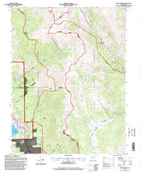
 1994 Mount Logan1998 Print · USGSThe high peaks of Park County were transitioning into a modern recreation and conservation landscape during the 1990s. Researchers can trace historic river-valley settlements like Webster and Grant alongside landmarks like Lamping Cem and the Harold Roberts Tunnel.
 - 1994 Map of Glentivar, 1998 Print
 1994 Glentivar1998 Print · USGSPark County high country during the mid-nineties shows a landscape of mountain passes and forestry activity. Researchers can trace the Glentivar (Site) settlement and locate numerous high-altitude prospects near Wilkerson Pass and Schoolmarm Mountain.2 unique versions available
 - 1994 Map of Thirtynine Mile Mountain, 1998 Print
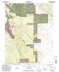
 1994 Thirtynine Mile Mountain1998 Print · USGSPark County high country comes into focus in the mid-nineties, showing the intersection of mountain ranching and mineral exploration. Researchers can trace the Homestake Pipeline, locate dozens of Prospects, and find the early layout of Guffey.2 unique versions available
 - 1994 Map of Spinney Mountain, 1998 Print
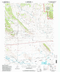
 1994 Spinney Mountain1998 Print · USGSPark County high country in the 1990s centers on the reservoirs of the South Platte River. Researchers can trace land divisions of the Hartsel Ranch or locate the peaks of Stoll Mountain and Spinney Mountain.
 - 1994 Map of Hackett Mountain, 1998 Print
 1994 Hackett Mountain1998 Print · USGSThe Colorado high country of Teller and Park counties is mapped here in the late twentieth century, showing a landscape defined by forest service roads and wilderness boundaries. Trace old mountain routes like Phantom Cr Road or locate historical sites like Goethite Mill and Custer Cabins.2 unique versions available
 - 1994 Map of Marmot Peak, 1998 Print
 1994 Marmot Peak1998 Print · USGSThe high Divide country of Chaffee and Park counties is shown here in the 1990s as a landscape of wilderness and resource exploration. Trace early mining efforts through scattered Mines and Prospect sites near the Lenhardy Cutoff and Marmot Peak.
 - 1994 Map of Cameron Mountain, 1998 Print
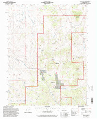
 1994 Cameron Mountain1998 Print · USGSThe high country of Chaffee and Park counties is mapped here during the mid-nineties, showing a landscape shaped by mining and forest management. Researchers can locate the Gold Bug Mine, the settlement of Whitehorn, and the remote Bassam Guard Station.
 - 1994 Map of Como, 1998 Print
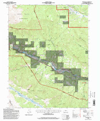
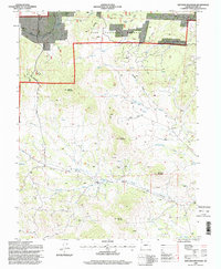
 1994 Como1998 Print · USGSPark County high country in the 1990s reveals a landscape of former mining camps and enduring family ranches. Genealogists and researchers can trace the vicinity of Como, identifying the Como Cem, the Fremont Sch (Site), and several historic sites like Peabody's.
 - 1994 Map of Climax, 1998 Print
 1994 Climax1998 Print · USGSHigh in the Colorado Rockies during the mid-nineties, this survey captures the intersection of industrial mining and the Continental Divide. Researchers can trace historic access routes like Mosquito Pass and industrial sites including London Mine and the Pennsylvania Tunnel.
 - 1994 Map of Agate Mountain, 1998 Print
 1994 Agate Mountain1998 Print · USGSPark County during the late twentieth century reveals a high-country landscape of resource extraction and national forest management. Genealogists and historians can trace the remote settlement of Trump or locate various Prospects and Quarries near Agate Mountain.
 - 1994 Map of Harvard Lakes, 1998 Print
 1994 Harvard Lakes1998 Print · USGSThe Arkansas River valley in the mid-nineties shows a landscape of mountain settlements and wilderness boundaries. Researchers can trace the water infrastructure of Riverside and Americus or locate high-country landmarks like Harvard Lakes and Elephant Rock.
 - 1994 Map of Witcher Mountain, 1998 Print
 1994 Witcher Mountain1998 Print · USGSHigh-country Park County is shown during the 1990s as a landscape of forest management and water infrastructure. Researchers can trace the Homestake Pipeline through the gulches or locate remote prospects near Witcher Mountain and Doe Ridge.
 - 1994 Map of Garo, 1998 Print
 1994 Garo1998 Print · USGSRanching and water rights dominate this Park County landscape in the 1990s, where the high plains meet the forest edge. Trace family-owned history through the McDowell Ranch, the Weston site, and the extensive Miller Ditch irrigation system.
Showing maps 1-25 of 41
Top cities of Park County
Frequently asked questions
- What are the different types of historical maps available for Park County?
- What is the oldest map of Park County?
- Where can I purchase historical maps of Park County for my home or office?
- Where can I download high-res historical maps of Park County?
- Are there historical topographic maps available for Park County?
- Is there historical aerial imagery available for Park County?
- Where are historical maps of Park County sourced from?