1910s Maps of Rio Blanco County, Colorado
Explore 7 historic maps of Rio Blanco County from the 1910s. These maps offer a rare glimpse into what life looked like during the 1910s — showing old roads, neighborhoods, homes, and landmarks that have changed or disappeared over time.
Whether you're researching your family's past, planning a metal detecting trip, or studying how Rio Blanco County's landscape evolved across the 1910s, these high-resolution maps are a powerful tool for exploring the history of this region.
- Focus on a specific era: All maps on this page are from the 1910s, giving you a focused view of this time period.
- See what’s changed: Compare century-old streets, trails, and buildings to today's modern landscape using overlays and satellite layers.
- Research with precision: Use these maps for genealogy, historical research, land use analysis, or educational projects.
- View, download, or print: Maps are fully viewable online in high resolution, and can be downloaded or printed for your own records.
Start exploring Rio Blanco County's history through authentic maps from the 1910s. This is your window into the past.
Rio Blanco County, CO maps
(7)- 1910 Map of Danforth Hills
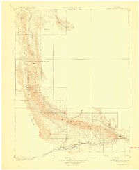
 1910 Danforth Hills1910 Print · USGSNorthwest Colorado is surveyed here in the early 1900s, showing a landscape defined by the rugged Danforth Hills and the early ranching outposts of Routt and Rio Blanco counties. Genealogists can locate family holdings like Edinger's Ranch and Maudlin's Ranch or trace the early post offices at Lay PO and Hamilton PO.
 - 1910 Map of Jensen
 1910 Jensen1910 Print · USGSThe Utah-Colorado borderlands come alive in the first decade of the twentieth century, showing the early development of the Uinta Basin. Genealogists and historians can locate early river crossings at the ferry sites near Jensen or trace the road to Dragon Stage Road.2 unique versions available
 - 1910 Map of Grand Hogback
 1910 Grand Hogback1910 Print · USGSGarfield and Rio Blanco counties appear at the height of the early railroad era, defined by the towering spine of the Grand Hogback. Local historians can trace the early rail stops and river settlements like Rio Blanco, Antlers, and Dinner Sta.3 unique versions available
 - 1910 Map of White River
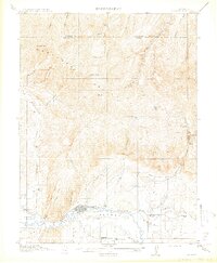
 1910 White River1910 Print · USGSNorthwest Colorado is captured here in the early twentieth century as a landscape of remote river valleys and high plateaus. Local historians can trace early crossings like Thornburgh Bridge and old outposts such as Maybell P O and Keystone Ranch.2 unique versions available
 - 1910 Map of Rangely
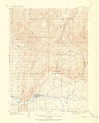
 1910 Rangely1910 Print · USGSNorthwestern Colorado at the turn of the century reveals a landscape of isolated outposts and cattle country along the river basins. Genealogists and researchers can trace the early footprints of Rangely, Angora, and Boxelder near the White River.2 unique versions available
 - 1912 Map of Meeker, 1954 Print
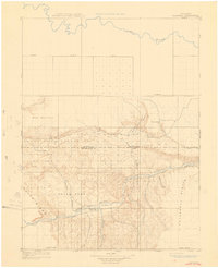
 1912 Meeker1954 Print · USGSThe White River valley near Meeker comes alive in the early twentieth century, showing a landscape of pioneer ranching and early rural schooling. Researchers can locate family landmarks like the Uehlein Ranch and trace the footprints of the Powell Park School or Coal Creek School.2 unique versions available
 - 1914 Map of Meeker
 1914 Meeker1914 Print · USGSThe White River valley in northwestern Colorado appears here just before the First World War, when ranching and small rural schoolhouses defined the landscape. Researchers can trace early family homesteads like Valentine Ranch and James Ranch or locate the Powell Park School.
End of results
Showing maps 1-7 of 7
Top cities of Rio Blanco County
Frequently asked questions
- What are the different types of historical maps available for Rio Blanco County?
- What is the oldest map of Rio Blanco County?
- Where can I purchase historical maps of Rio Blanco County for my home or office?
- Where can I download high-res historical maps of Rio Blanco County?
- Are there historical topographic maps available for Rio Blanco County?
- Is there historical aerial imagery available for Rio Blanco County?
- Where are historical maps of Rio Blanco County sourced from?