2000-2009 Maps of Rio Blanco County, Colorado
Explore 6 historic maps of Rio Blanco County from 2000-2009. These maps offer a rare glimpse into what life looked like during the 2000s — showing old roads, neighborhoods, homes, and landmarks that have changed or disappeared over time.
Whether you're researching your family's past, planning a metal detecting trip, or studying how Rio Blanco County's landscape evolved across the 2000s, these high-resolution maps are a powerful tool for exploring the history of this region.
- Focus on a specific era: All maps on this page are from the 2000s, giving you a focused view of this time period.
- See what’s changed: Compare century-old streets, trails, and buildings to today's modern landscape using overlays and satellite layers.
- Research with precision: Use these maps for genealogy, historical research, land use analysis, or educational projects.
- View, download, or print: Maps are fully viewable online in high resolution, and can be downloaded or printed for your own records.
Start exploring Rio Blanco County's history through authentic maps from the 2000s. This is your window into the past.
Rio Blanco County, CO maps
(6)- 2000 Map of Pagoda Peak
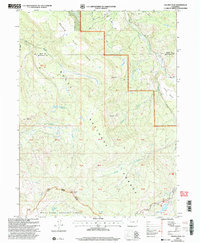 2000 Pagoda Peak2000 Print · USGSHigh Colorado wilderness at the turn of the millennium centers on the prominent Pagoda Peak and the surrounding national forests. Local historians and hikers can trace the path of the Flat Tops Scenic Byway near Vaughan Lake and the remote reaches of Stinsby Reservoir.
 - 2000 Map of Devils Causeway, 2004 Print
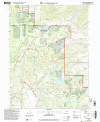
 2000 Devils Causeway2004 Print · USGSThe Colorado high country at the turn of the millennium is revealed in this detailed study of the border between Rio Blanco and Garfield counties. Researchers can trace the dramatic terrain of the Chinese Wall, find remote waters like Deep Lake, and locate the iconic Devils Causeway ridge.
 - 2000 Map of Orno Peak, 2004 Print
 2000 Orno Peak2004 Print · USGSGarfield and Routt counties are shown at the turn of the millennium, defined by the high plateaus and alpine drainages of the Flat Tops Wilderness. Researchers can trace historic routes like the Ute Trail and locate remote landmarks like Orno Peak and Yamcolo Reservoir.
 - 2000 Map of Sand Point, 2004 Print
 2000 Sand Point2004 Print · USGSThe high plateaus of the Colorado Rockies are captured here at the turn of the millennium, documenting a landscape of rugged peaks and vital water infrastructure. Researchers can trace historic irrigation systems like the Trout Creek School Ditch and Last Chance Ditch near Sand Point.
 - 2000 Map of Dunckley Pass, 2004 Print
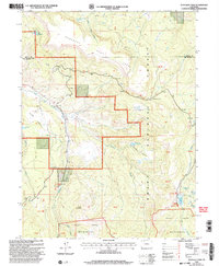 2000 Dunckley Pass2004 Print · USGSRoutt and Rio Blanco counties meet at the high plateaus of this turn-of-the-century survey. Researchers can trace the rugged transition from Egry Mesa to the Flat Tops Wilderness, passing through Dunckley Pass and Sheriff Reservoir.
 - 2000 Map of Slide Creek, 2004 Print
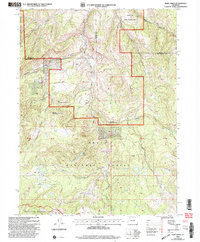 2000 Slide Creek2004 Print · USGSThe high country of the White River and Routt National Forests is captured here at the turn of the millennium. Researchers can trace the drainage of the Williams Fork or locate landmarks like Big Sugarloaf Mountain, Berry Lake, and the Indian Run State Wildlife Area.
End of results
Showing maps 1-6 of 6
Top cities of Rio Blanco County
Frequently asked questions
- What are the different types of historical maps available for Rio Blanco County?
- What is the oldest map of Rio Blanco County?
- Where can I purchase historical maps of Rio Blanco County for my home or office?
- Where can I download high-res historical maps of Rio Blanco County?
- Are there historical topographic maps available for Rio Blanco County?
- Is there historical aerial imagery available for Rio Blanco County?
- Where are historical maps of Rio Blanco County sourced from?