1950s Maps of Rio Blanco County, Colorado
Explore 18 historic maps of Rio Blanco County from the 1950s. These maps offer a rare glimpse into what life looked like during the 1950s — showing old roads, neighborhoods, homes, and landmarks that have changed or disappeared over time.
Whether you're researching your family's past, planning a metal detecting trip, or studying how Rio Blanco County's landscape evolved across the 1950s, these high-resolution maps are a powerful tool for exploring the history of this region.
- Focus on a specific era: All maps on this page are from the 1950s, giving you a focused view of this time period.
- See what’s changed: Compare century-old streets, trails, and buildings to today's modern landscape using overlays and satellite layers.
- Research with precision: Use these maps for genealogy, historical research, land use analysis, or educational projects.
- View, download, or print: Maps are fully viewable online in high resolution, and can be downloaded or printed for your own records.
Start exploring Rio Blanco County's history through authentic maps from the 1950s. This is your window into the past.
Rio Blanco County, CO maps
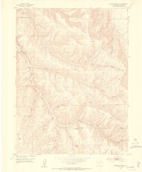
(18)- 1952 Map of Wolf Ridge, 1953 Print
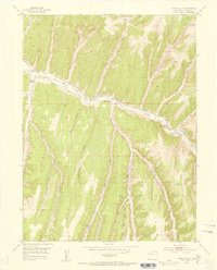
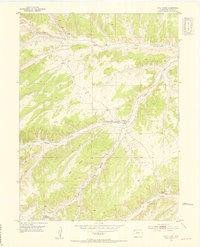 1952 Wolf Ridge1953 Print · USGSThe Colorado plateau of Rio Blanco County is shown during the early 1950s, a period defined by remote ranching and essential water management. Researchers can trace local landmarks like Ryan School and the 84 Ranch or follow the paths of Corral Gulch and Wolf Ridge.7 unique versions available
 - 1952 Map of Yankee Gulch, 1954 Print
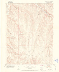
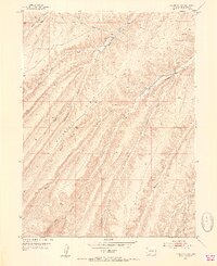 1952 Yankee Gulch1954 Print · USGSRio Blanco County at the start of the fifties shows a high-altitude landscape where travel followed the topography. Map collectors can trace the long Wagon Road and locate family-named sites like Duckett Ranch and Reigle Ranch.6 unique versions available
 - 1952 Map of Rio Blanco, 1954 Print
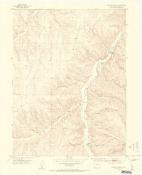
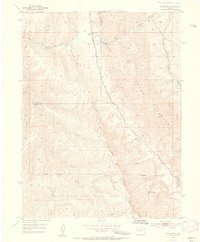 1952 Rio Blanco1954 Print · USGSDeep in the Western Slope during the early fifties, this area centers on the small settlement of Rio Blanco. Local historians can trace the Rio Blanco School, the Rio Blanco Mine, and the original path of the Government Road.5 unique versions available
 - 1952 Map of Rock School, 1954 Print
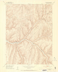
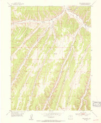 1952 Rock School1954 Print · USGSIn the early fifties, this section of Rio Blanco County was a landscape of remote ranchlands and deep canyons. Researchers can locate the landmark Rock School along Piceance Creek and trace the rugged courses of Black Sulphur Creek and Hunter Creek.6 unique versions available
 - 1952 Map of Jessup Gulch, 1954 Print
 1952 Jessup Gulch1954 Print · USGSRio Blanco County ranching culture and early resource extraction are captured here in the early fifties. Genealogists can trace family landmarks like the Walter Oldland Ranch, Redd Ranch, and the Stewart School.6 unique versions available
 - 1952 Map of Greasewood Gulch, 1954 Print
 1952 Greasewood Gulch1954 Print · USGSRio Blanco County in the early fifties shows a landscape of wildlife research and emerging energy exploration. Trace early industrial footprints and remote outposts like the Little Hills Game Experiment Station, Magnolia Camp, and various Gas Wells.6 unique versions available
 - 1952 Map of Square S Ranch, 1954 Print
 1952 Square S Ranch1954 Print · USGSRio Blanco County ranching country is documented in the early fifties, showing a landscape of deep gulches and isolated outposts. Researchers can locate Square S Ranch, the Miller Hill Cem, and the prominent Dudley Bluffs.5 unique versions available
 - 1952 Map of No Name Ridge, 1954 Print
 1952 No Name Ridge1954 Print · USGSRio Blanco County ranching and early energy exploration are captured here in the early fifties. Researchers can trace family homesteads like Cox Ranch or Robinson Ranch and locate early Shale Prospects along the drainages of Piceance Creek.6 unique versions available
 - 1952 Map of Segar Mountain, 1954 Print
 1952 Segar Mountain1954 Print · USGSThe high country of Rio Blanco County in the early 1950s reveals a landscape of remote cattle camps and wildlife research. Trace local history at the Little Hills Game Experiment Station or locate the Oldland Cow Camp and its nearby Fish Hatchery.5 unique versions available
 - 1954 Map of Vernal, 1966 Print
 1954 Vernal1966 Print · USGSThe Green River basin and Uinta Mountains come alive in this mid-century survey of northeastern Utah and northwestern Colorado. Genealogists and researchers can trace the development of remote outposts like Little Bonanza, Artesia, and Dutch John alongside the expanding Flaming Gorge Reservoir.4 unique versions available
 - 1954 Map of Craig, 1973 Print
 1954 Craig1973 Print · USGSNorthwest Colorado and the high mountain parks are captured in the mid-fifties, showing the region's ranching, mining, and timber centers. Genealogists and historians can trace rail corridors like the Denver and Rio Grande Western and old towns such as Axial, Milner, and Coalmont.3 unique versions available
 - 1956 Map of Grand Junction, 1973 Print
 1956 Grand Junction1973 Print · USGSThe Grand Valley and its surrounding high plateaus are captured here in the mid-twentieth century as the region's ranching and rail heritage remained central. Researchers can trace the path of the Denver & Rio Grande Western RR through Grand Junction or locate remote outposts like Dragon and Atchee.2 unique versions available
 - 1957 Map of Craig
 1957 Craig1957 Print · USGSNorthwest Colorado in the mid-fifties is a landscape of mountain ranching and rail-dependent river towns. Researchers can trace historic coal mining at the Sudduth Mine, follow the Denver and Rio Grande Western tracks, and locate vanished settlements like Pearl.
 - 1957 Map of Leadville, 1978 Print
 1957 Leadville1978 Print · USGSHigh-country mining and rail transport define the central Colorado Rockies during the mid-to-late twentieth century. Researchers can trace the industrial footprints of Gilman and Climax, find small rail stops like Malta, and follow the Denver and Rio Grande Western RR.2 unique versions available
 - 1958 Map of Vernal
 1958 Vernal1958 Print · USGSThe Uinta Basin at the end of the fifties reveals a landscape shaped by massive river systems and burgeoning energy interests. Researchers can trace the layout of Uintah and Ouray Indian Reservation lands and industrial sites like the Gilsonite coking plant and Bonanza.
 - 1958 Map of Craig
 1958 Craig1958 Print · USGSNorthwest Colorado and the High Rockies are captured here in the mid-fifties, showing a landscape of burgeoning water projects and mountain ranching. Genealogists and historians can trace old homesteads and mountain outposts from Grand Lake to Meeker, alongside industrial landmarks like Uranium Mines and the Denver and Rio Grande Western railroad.
 - 1959 Map of Grand Junction
 1959 Grand Junction1959 Print · USGSThe Grand Valley and the high plateaus of the Colorado-Utah border come into focus in the late fifties as irrigation and rail lines define the landscape. Local historians can trace several industrial outposts labeled as abandoned, including Watson and Dragon, alongside the Denver and Rio Grande Western RR.
 - 1959 Map of Leadville
 1959 Leadville1959 Print · USGSThe Colorado high country in the late fifties is a landscape of mining history and military training, from the streets of Leadville to the Camp Hale grounds. Genealogists and historians can trace the Denver and Rio Grande Western RR alongside now-deserted sites like Ashcroft and Independence.
End of results
Showing maps 1-18 of 18
Top cities of Rio Blanco County
Frequently asked questions
- What are the different types of historical maps available for Rio Blanco County?
- What is the oldest map of Rio Blanco County?
- Where can I purchase historical maps of Rio Blanco County for my home or office?
- Where can I download high-res historical maps of Rio Blanco County?
- Are there historical topographic maps available for Rio Blanco County?
- Is there historical aerial imagery available for Rio Blanco County?
- Where are historical maps of Rio Blanco County sourced from?