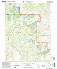
2000 Map of Sand Point
USGS Topo · Published 2004About this map
Flat Tops Wilderness and the Routt National Forest define this high-altitude landscape along the border of Routt and Rio Blanco counties. The area is characterized by an intricate network of water management features necessary for high-country ranching and agriculture, including the Trout Creek School Ditch, Last Chance Ditch, and Alpha Ditch. These diversions draw from numerous water bodies such as Crosho Lake and Allen Basin Reservoir to support the lower elevations. The terrain is marked by prominent elevations like Pinnacle Peak and Bellyache Mountain, with the Flat Tops plateau dominating the southern portion of the survey. Significant water storage is evident at Chapman Reservoir and Killarney Reservoir, while a Scenic Byway provides modern access through the northeastern mountain passes.
Find a feature on this map
39 named features on this map. Tap any name to fly to it.
Don’t see what you’re looking for? This feature index may not catch every label — zoom into the map to look around manually.
Map Details
Editions of this 2000 Sand Point Map
This is the sole edition of this map. No revisions or reprints were ever made.
Other maps of this area

1924 · Mt. Harris
USGS Topo · 1:48,000

1926 · Mount Harris
USGS Topo · 1:62,500

1954 · Craig
USGS Topo · 1:250,000

1957 · Craig
USGS Topo · 1:250,000

1958 · Craig
USGS Topo · 1:250,000

1960 · Craig
USGS Topo · 1:250,000

1962 · Craig
USGS Topo · 1:250,000

1964 · Craig
USGS Topo · 1:250,000

1965 · Craig
USGS Topo · 1:250,000
1966 · Dunckley Pass
USGS Topo · 1:24,000