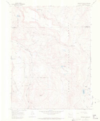
1966 Map of Dunckley Pass
USGS Topo · Published 1969About this map
Routt National Forest dominates this high-altitude landscape along the border of Routt and Rio Blanco counties. The terrain is defined by dramatic elevation changes, rising from the Williams Fork drainage up to the sprawling Dunckley Flat and the summit of Baldy Mountain. This mid-1960s survey captures a wilderness managed for both natural resources and recreation, evidenced by the network of a Jeep Trail and a Pack Trail that traverse the ridges. Water management is a central theme of the era's land use, with numerous high-country catchments such as Sheriff Reservoir, Haley Reservoir, and J O K Reservoir No 1 scattered across the plateau. The inclusion of the Pyramid Guard Station highlights the administrative presence required to oversee this remote timber and grazing land.
Find a feature on this map
30 named features on this map. Tap any name to fly to it.
Don’t see what you’re looking for? This feature index may not catch every label — zoom into the map to look around manually.
Map Details
Editions of this 1966 Dunckley Pass Map
2 editions found
Other maps of this area

1916 · Daton Peak
USGS Topo · 1:62,500

1920 · Daton Peak
USGS Topo · 1:62,500

1924 · Mt. Harris
USGS Topo · 1:48,000

1926 · Mount Harris
USGS Topo · 1:62,500

1954 · Craig
USGS Topo · 1:250,000

1957 · Craig
USGS Topo · 1:250,000

1958 · Craig
USGS Topo · 1:250,000

1960 · Craig
USGS Topo · 1:250,000

1962 · Craig
USGS Topo · 1:250,000

1964 · Craig
USGS Topo · 1:250,000