1960s Maps of Delaware
Explore 10 historic maps of Delaware from the 1960s. These maps offer a rare glimpse into what life looked like during the 1960s — showing old roads, neighborhoods, homes, and landmarks that have changed or disappeared over time.
Whether you're researching your family's past, planning a metal detecting trip, or studying how Delaware's landscape evolved across the 1960s, these high-resolution maps are a powerful tool for exploring the history of this region.
- Focus on a specific era: All maps on this page are from the 1960s, giving you a focused view of this time period.
- See what’s changed: Compare century-old streets, trails, and buildings to today's modern landscape using overlays and satellite layers.
- Research with precision: Use these maps for genealogy, historical research, land use analysis, or educational projects.
- View, download, or print: Maps are fully viewable online in high resolution, and can be downloaded or printed for your own records.
Start exploring Delaware's history through authentic maps from the 1960s. This is your window into the past.
Delaware maps
(10)- 1961 Map of Ocean City
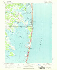
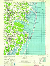 1961 Ocean City1961 Print · USGSThe Maryland and Delaware coastlines come alive in this mid-century survey of the barrier islands and quiet inland towns. Genealogists and historians can trace the early layout of Ocean City and Berlin, or locate vanished rail stops along the Philadelphia Wilmington and Baltimore RR.
 - 1961 Map of Salisbury
 1961 Salisbury1961 Print · USGSThe Delmarva Peninsula comes into focus in the early sixties, showing the vital road and rail networks connecting the Chesapeake to the Atlantic. Genealogists and historians can trace family-named landings and coastal landmarks from Crisfield to the Brandywine Shoal Lighthouse.
 - 1965 Map of Salisbury
 1965 Salisbury1965 Print · USGSThe Delmarva Peninsula in the mid-1960s is depicted here as a landscape of coastal defenses and maritime hubs. Genealogists and local historians can trace the foundations of bayside towns like Crisfield and the tactical positioning of the Fort Miles Military Reservation and Cape May Naval Air Station.
 - 1966 Map of Wilmington, 1968 Print
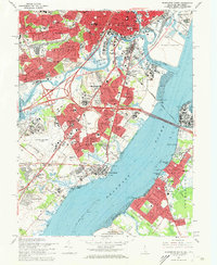
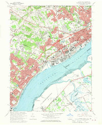
 1966 Wilmington1968 Print · USGSThe Delaware Valley and Jersey Shore are seen here in the mid-1960s, documenting a landscape of dense industrial cities and emerging coastal resorts. Researchers can trace the sprawling rail networks of the Pennsylvania Railroad or locate landmarks like Fort Dix Military Reservation and Elk Neck State Park.4 unique versions available
 - 1967 Map of Selbyville, 1969 Print
 1967 Selbyville1969 Print · USGSThe Delaware-Maryland border region near Selbyville comes to life in the late 1960s, showing a landscape of rail-linked towns and tidal creeks. Genealogists can locate family landmarks like Old St Martins Ch, Showell Sch, and the Wilgus Cem.3 unique versions available
 - 1967 Map of Wilmington North, 1969 Print
 1967 Wilmington North1969 Print · USGSNorthern Delaware and southeastern Pennsylvania show a mix of suburban growth and preserved estates during the late sixties. Trace family history at Chesed Shel emeth Cem or locate old rail junctions like Chadds Ford Junction and Cossart.4 unique versions available
 - 1967 Map of Penns Grove, 1969 Print
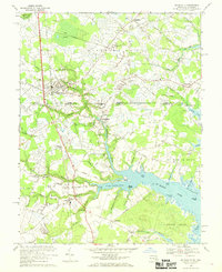
 1967 Penns Grove1969 Print · USGSThe riverfront of Salem County is captured here in the late sixties as industrial hubs and suburban manors expanded alongside the historic Delaware. Trace family roots at Perkintown Cem, the St James Ch, or the small settlement of Marshalltown.2 unique versions available
 - 1967 Map of Assawoman Bay, 1969 Print
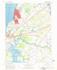
 1967 Assawoman Bay1969 Print · USGSThe coastal border of Delaware and Maryland is captured here in the late sixties as vacation communities began to expand. Genealogists and historians can trace old landings like Sassafras Landing, the historic Fenwick Island Lighthouse, and the Sound Ch.4 unique versions available
 - 1967 Map of Wilmington South, 1969 Print
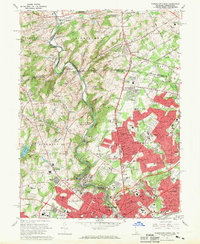
 1967 Wilmington South1969 Print · USGSThe industrial corridor between Wilmington and New Castle is captured here during a period of intense suburban growth. Researchers can trace family roots through numerous sites like Gracelawn Mem Park (Cemetery), Wm Penn High Sch, and the Air National Guard base.3 unique versions available
 - 1967 Map of Marcus Hook, 1970 Print
 1967 Marcus Hook1970 Print · USGSThe industrial corridor of the Delaware River transitions into the established suburbs of Pennsylvania and Delaware during the late sixties. Researchers can trace historic landmarks like the St Patricks Monastery, the grounds of Archmere Prep Sch, and the rail junctions of the Baltimore and Ohio.3 unique versions available
End of results
Showing maps 1-10 of 10
Top cities of Delaware
- Wilmington historical maps
- Dover historical maps
- Newark historical maps
- Hockessin historical maps
- Smyrna historical maps
- Middletown historical maps
See more
Top counties of Delaware
Frequently asked questions
- What are the different types of historical maps available for Delaware?
- What is the oldest map of Delaware?
- Where can I purchase historical maps of Delaware for my home or office?
- Where can I download high-res historical maps of Delaware?
- Are there historical topographic maps available for Delaware?
- Is there historical aerial imagery available for Delaware?
- Where are historical maps of Delaware sourced from?