1980s Maps of Delaware
Explore 19 historic maps of Delaware from the 1980s. These maps offer a rare glimpse into what life looked like during the 1980s — showing old roads, neighborhoods, homes, and landmarks that have changed or disappeared over time.
Whether you're researching your family's past, planning a metal detecting trip, or studying how Delaware's landscape evolved across the 1980s, these high-resolution maps are a powerful tool for exploring the history of this region.
- Focus on a specific era: All maps on this page are from the 1980s, giving you a focused view of this time period.
- See what’s changed: Compare century-old streets, trails, and buildings to today's modern landscape using overlays and satellite layers.
- Research with precision: Use these maps for genealogy, historical research, land use analysis, or educational projects.
- View, download, or print: Maps are fully viewable online in high resolution, and can be downloaded or printed for your own records.
Start exploring Delaware's history through authentic maps from the 1980s. This is your window into the past.
Delaware maps
(19)- 1980 Map of Fairmount, 1982 Print
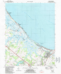
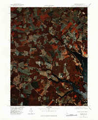 1980 Fairmount1982 Print · USGSSussex County, Delaware, is captured in the early eighties as a mosaic of tidal marshes and family farms. Researchers can trace the layout of rural communities like Robinsonville and Belltown or study the shoreline along Rehoboth Bay.
 - 1980 Map of Selbyville, 1982 Print
 1980 Selbyville1982 Print · USGSThe Delaware-Maryland borderlands appear in striking infrared detail during the early 1980s, showing a landscape defined by traditional agriculture and winding waterways. Researchers can trace the rural layouts of Selbyville, Bishopville, and Roxana as they existed forty years ago.
 - 1980 Map of Cape Henlopen, 1982 Print
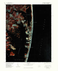
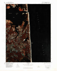
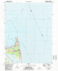
 1980 Cape Henlopen1982 Print · USGSThe Sussex County coast comes alive in this 1980s color infrared survey, showing the transition from bay to ocean. Trace the shifting sands of Cape Henlopen and the early layout of Lewes during this era of coastal change.
 - 1980 Map of Frankford, 1982 Print
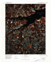 1980 Frankford1982 Print · USGSSussex County coastal wetlands and agricultural fields are captured in this early 1980s infrared survey. Local researchers can trace the shorelines of Indian River Bay and locate the historic settlements of Dagsboro, Frankford, and Oak Orchard.
 - 1980 Map of Assawoman Bay, 1982 Print
 1980 Assawoman Bay1982 Print · USGSCoastal Maryland and Delaware are seen here in the early eighties as beachfront development reshaped the barrier islands. Trace the growth of Ocean City and Fenwick Island between the Atlantic Ocean and Assawoman Bay.
 - 1980 Map of Bethany Beach, 1982 Print
 1980 Bethany Beach1982 Print · USGSThe Delaware coast in the early eighties shows a unique period of growth between the quiet shore and the bays. Trace the development of Bethany Beach and inland towns like Millville and Ocean View along the tidal waters of White Creek.
 - 1980 Map of Lewes, 1982 Print
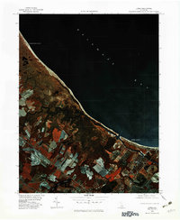 1980 Lewes1982 Print · USGSSussex County's shoreline and coastal marshes appear in vivid infrared detail in the early eighties. Genealogists and local historians can trace the development of Lewes Beach and identify landmarks like Red Mill Pond and the Broadkill River.
 - 1980 Map of Rehoboth Beach, 1982 Print
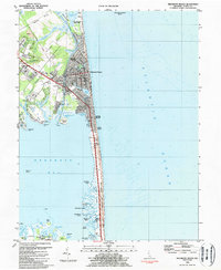
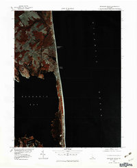 1980 Rehoboth Beach1982 Print · USGSThe Delaware coast in the early eighties shows a landscape of growing beach communities and expansive bay waters. Local historians can trace the residential footprints of Rehoboth Beach and Dewey Beach alongside Rehoboth Bay.
 - 1981 Map of Cape May, 1982 Print
 1981 Cape May1982 Print · USGSThe Jersey Shore's southernmost reaches come into focus during the early eighties, showcasing the maritime infrastructure of the Cape. Researchers can trace the layout of coastal towns like Wildwood Crest and North Cape May or locate the sprawling U.S. Coast Guard Training Center.
 - 1983 Map of Salisbury, 1984 Print
 1983 Salisbury1984 Print · USGSThe Lower Eastern Shore was a landscape of tide and timber in the early eighties, from the bustling streets of Salisbury to the wild coast of Assateague Island. Researchers can trace the rail-and-road network of the Conrail and U S Highway 50 while locating historic centers like Princess Anne and Crisfield.
 - 1984 Map of Lewes
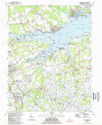
 1984 Lewes1984 Print · USGSThe Sussex County coast in the mid-1980s reveals a landscape of protected wetlands and maritime industry. Genealogists can trace family names at Whites Chapel or Henlopen Memorial Park, while explorers find old landings like Hazzard Landing.3 unique versions available
 - 1984 Map of Fairmount
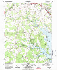 1984 Fairmount1984 Print · USGSSussex County coastal life in the mid-1980s is centered on the tidal reaches of Rehoboth Bay and its inland farming communities. Genealogists and historians can trace local roots through landmarks like the Indian Mission Ch, Goslee Millpond, and St Georges Chapel.3 unique versions available
 - 1984 Map of Frankford
 1984 Frankford1984 Print · USGSIn the 1980s, the Sussex County coast shows a blend of historic farmsteads and burgeoning bayfront communities. Genealogists and historians can trace local roots through landmarks like Prince George Chapel, Carey Cem, and the Nanticoke Indian Center.2 unique versions available
 - 1984 Map of Bethany Beach
 1984 Bethany Beach1984 Print · USGSThe Delaware coast in the early eighties shows a landscape of growing beach towns and preserved marshes. Trace the development of Bethany Beach and South Bethany, or locate inland landmarks like the Lord Baltimore Sch and Millville.2 unique versions available
 - 1984 Map of Cape Henlopen
 1984 Cape Henlopen1984 Print · USGSThe Delaware coastline in the mid-1980s reveals a strategic landscape of naval reservations and maritime heritage near the mouth of the bay. Researchers can trace the boundaries of Lewes and explore coastal features like Gordons Pond and the Harbor of Refuge.4 unique versions available
 - 1984 Map of Rehoboth Beach
 1984 Rehoboth Beach1984 Print · USGSThe Delaware coast thrived as a premier mid-Atlantic resort destination during the 1980s, balancing growing beachfront communities with preserved salt marshes. Researchers can trace the layout of Dewey Beach, locate historic sites like All Saints Ch, and explore the diverse island chain of Rehoboth Bay.3 unique versions available
 - 1984 Map of Dover, 1985 Print
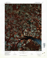
 1984 Dover1985 Print · USGSThe Delaware Bay coastline and its surrounding communities are captured here in the mid-1980s. Genealogists and historians can trace the growth of Dover, locate rural landmarks like St Augustine, or study the rail networks of CONRAIL and the Dover Air Force Base.
 - 1984 Map of Wilmington, 1986 Print
 1984 Wilmington1986 Print · USGSThe Delaware Valley in the mid-eighties was a powerhouse of transit and industry where Delaware, New Jersey, Pennsylvania, and Maryland meet. Researchers can trace the sprawling rail networks of SEPTA and PATCO or locate historic sites like Fort Delaware State Park and Valley Forge State Forest.2 unique versions available
 - 1984 Map of Seaford, 1986 Print
 1984 Seaford1986 Print · USGSCoastal Delaware and the Maryland borderlands are captured here in the mid-eighties as modern tourism and traditional agriculture coexist. Researchers can trace the rail-and-river routes through Seaford, explore inland millponds like Chipman Pond, or study the shoreline at Cape Henlopen.2 unique versions available
End of results
Showing maps 1-19 of 19
Top cities of Delaware
- Wilmington historical maps
- Dover historical maps
- Newark historical maps
- Hockessin historical maps
- Smyrna historical maps
- Middletown historical maps
See more
Top counties of Delaware
Frequently asked questions
- What are the different types of historical maps available for Delaware?
- What is the oldest map of Delaware?
- Where can I purchase historical maps of Delaware for my home or office?
- Where can I download high-res historical maps of Delaware?
- Are there historical topographic maps available for Delaware?
- Is there historical aerial imagery available for Delaware?
- Where are historical maps of Delaware sourced from?