1990s Maps of Collier County, Florida
Explore 6 historic maps of Collier County from the 1990s. These maps offer a rare glimpse into what life looked like during the 1990s — showing old roads, neighborhoods, homes, and landmarks that have changed or disappeared over time.
Whether you're researching your family's past, planning a metal detecting trip, or studying how Collier County's landscape evolved across the 1990s, these high-resolution maps are a powerful tool for exploring the history of this region.
- Focus on a specific era: All maps on this page are from the 1990s, giving you a focused view of this time period.
- See what’s changed: Compare century-old streets, trails, and buildings to today's modern landscape using overlays and satellite layers.
- Research with precision: Use these maps for genealogy, historical research, land use analysis, or educational projects.
- View, download, or print: Maps are fully viewable online in high resolution, and can be downloaded or printed for your own records.
Start exploring Collier County's history through authentic maps from the 1990s. This is your window into the past.
Collier County, FL maps
(6)- 1995 Map of Fiftymile Bend, 1999 Print
 1995 Fiftymile Bend1999 Print · USGSThe Florida Everglades of the 1990s are captured here as the landscape transitions through the Big Cypress National Preserve. Genealogists and historians can trace small settlements and stops like Pinecrest, Paolita Station, and the Trail Gospel Center along the Tamiami Trail.
 - 1995 Map of Fortymile Bend, 1999 Print
 1995 Fortymile Bend1999 Print · USGSThe Miccosukee heartland and the eastern Everglades are documented here in the mid-1990s. Researchers can trace family-named sites like Tommy Tigers Camp and Pete Oseolas Farm alongside the historic Old Burying Ground.
 - 1995 Map of Monroe Station, 1999 Print
 1995 Monroe Station1999 Print · USGSThe Florida Everglades in the mid-1990s are mapped here as a complex network of wetlands and seasonal watercourses. Researchers can locate remote outposts like Monroe Station and Indian Village, or trace the paths of Sweetwater Strand and Gator Lakes through the preserve.
 - 1995 Map of Marco Island, 1999 Print
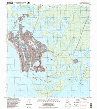 1995 Marco Island1999 Print · USGSMarco Island in the mid-nineties showcases a rapidly developing coastline defined by intricate canal systems and growing residential tracts. Researchers can trace local infrastructure from the Toll Bridge and Barfield Sch to the quiet fishing village of Goodland.
 - 1995 Map of North Of Fortymile Bend, 1999 Print
 1995 North Of Fortymile Bend1999 Print · USGSThe Florida Everglades in the mid-1990s reveal a landscape defined by indigenous residency and conservation boundaries. Genealogists and historians can locate specific sites like Mart Law Seminole Village, Sam Willie Seminole Village, and Sam Franks Old Farm.
 - 1995 Map of North Of Fiftymile Bend, 1999 Print
 1995 North Of Fiftymile Bend1999 Print · USGSBig Cypress in the mid-1990s represents a preserved wilderness of the Florida Everglades. Trace the path of the Corn Dance Trail and locate isolated landmarks like Threemile Island and the northern Hammock in this remote wetland landscape.
End of results
Showing maps 1-6 of 6
Top cities of Collier County
- Immokalee historical maps
- Immokalee historical maps
- Naples historical maps
- Marco Island historical maps
- Lely Resort historical maps
- Pelican Bay historical maps
See more
Frequently asked questions
- What are the different types of historical maps available for Collier County?
- What is the oldest map of Collier County?
- Where can I purchase historical maps of Collier County for my home or office?
- Where can I download high-res historical maps of Collier County?
- Are there historical topographic maps available for Collier County?
- Is there historical aerial imagery available for Collier County?
- Where are historical maps of Collier County sourced from?