1960s Maps of Tallahassee, Florida
Explore 5 historic maps of Tallahassee from the 1960s. These maps offer a rare glimpse into what life looked like during the 1960s — showing old roads, neighborhoods, homes, and landmarks that have changed or disappeared over time.
Whether you're researching your family's past, planning a metal detecting trip, or studying how Tallahassee's landscape evolved across the 1960s, these high-resolution maps are a powerful tool for exploring the history of this region.
- Focus on a specific era: All maps on this page are from the 1960s, giving you a focused view of this time period.
- See what’s changed: Compare century-old streets, trails, and buildings to today's modern landscape using overlays and satellite layers.
- Research with precision: Use these maps for genealogy, historical research, land use analysis, or educational projects.
- View, download, or print: Maps are fully viewable online in high resolution, and can be downloaded or printed for your own records.
Start exploring Tallahassee's history through authentic maps from the 1960s. This is your window into the past.
Tallahassee, FL maps
(5)- 1960 Map of Tallahassee
 1960 Tallahassee1960 Print · USGSThe Florida Panhandle and southern Georgia are captured here in the mid-twentieth century, showing a region defined by its rivers and military installations. Genealogists and historians can trace the growth of Tallahassee or locate coastal landmarks like the St Marks Lighthouse and Tyndall Air Force Base.
 - 1963 Map of Bradfordville, 1964 Print
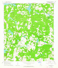 1963 Bradfordville1964 Print · USGSNorth of Tallahassee in the early sixties, this area shows a landscape of traditional communities and numerous named ponds. Genealogists and historians can locate family landmarks like the Bradford-Eppes Cem and long-standing congregations at Pisgah Ch or St Philips Ch.
 - 1963 Map of Lake Jackson, 1964 Print
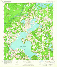 1963 Lake Jackson1964 Print · USGSNorth of Tallahassee in the early sixties, this area shows the initial wave of suburban growth around Lake Jackson. Genealogists and local historians can trace early subdivisions like Harbinwood Estates and rural landmarks such as St Marks Ch and the Seaboard Air Line railroad.
 - 1969 Map of Midway, 1972 Print
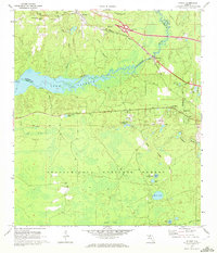 1969 Midway1972 Print · USGSThe Ochlockonee River valley and Lake Talquin come into focus during the late sixties, showing the quiet transition between the Apalachicola National Forest and rural settlements. Genealogists can locate family landmarks like Mt Moriah Ch, Norfleet, and several cemeteries scattered across the Gadsden county line.2 unique versions available
 - 1969 Map of Lake Munson, 1972 Print
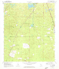 1969 Lake Munson1972 Print · USGSThe pine forests and wetlands south of Tallahassee are captured in the late sixties, showcasing the rural communities of Leon and Wakulla counties. Genealogists can locate family landmarks like St Peters Ch, Zion Hill Ch, and the settlement of Woodville along the Seaboard Coast Line.2 unique versions available
End of results
Showing maps 1-5 of 5
Top cities near Tallahassee
Top neighborhoods of Tallahassee
- Macon historical maps
- Perkins historical maps
- Oak Knoll Estates historical maps
- Saint Peter historical maps
- Lafayette historical maps
- Four Points historical maps
See more
Frequently asked questions
- What are the different types of historical maps available for Tallahassee?
- What is the oldest map of Tallahassee?
- Where can I purchase historical maps of Tallahassee for my home or office?
- Where can I download high-res historical maps of Tallahassee?
- Are there historical topographic maps available for Tallahassee?
- Is there historical aerial imagery available for Tallahassee?
- Where are historical maps of Tallahassee sourced from?