1980s Maps of Tallahassee, Florida
Explore 5 historic maps of Tallahassee from the 1980s. These maps offer a rare glimpse into what life looked like during the 1980s — showing old roads, neighborhoods, homes, and landmarks that have changed or disappeared over time.
Whether you're researching your family's past, planning a metal detecting trip, or studying how Tallahassee's landscape evolved across the 1980s, these high-resolution maps are a powerful tool for exploring the history of this region.
- Focus on a specific era: All maps on this page are from the 1980s, giving you a focused view of this time period.
- See what’s changed: Compare century-old streets, trails, and buildings to today's modern landscape using overlays and satellite layers.
- Research with precision: Use these maps for genealogy, historical research, land use analysis, or educational projects.
- View, download, or print: Maps are fully viewable online in high resolution, and can be downloaded or printed for your own records.
Start exploring Tallahassee's history through authentic maps from the 1980s. This is your window into the past.
Tallahassee, FL maps
(5)- 1981 Map of Woodville, 1982 Print
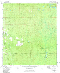 1981 Woodville1982 Print · USGSThe Leon and Wakulla county borderlands are shown here in the early eighties, centered on the historic site of the Natural Bridge Battlefield. Trace the path of the Seaboard Coast Line or locate family markers at Rhodes Cem and Godwin Cem.2 unique versions available
 - 1982 Map of Lafayette, 1983 Print
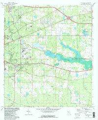 1982 Lafayette1983 Print · USGSEastern Leon County comes alive in the early eighties as the capital city meets the wetlands of Lake Lafayette. Genealogists and historians can trace local landmarks like St Peter Cem Ch, the Seminole Fish Hatchery, and the Federal Correctional Institution.2 unique versions available
 - 1982 Map of Lake Jackson, 1983 Print
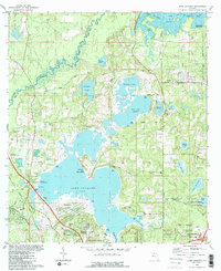 1982 Lake Jackson1983 Print · USGSNorth of Tallahassee in the early eighties, this area balances a growing suburban footprint with its ancient foundations at the Lake Jackson Mounds. Genealogists and historians can locate early family landmarks and estates, from El Destinado to Memory Gardens Cem and St Matthews Ch.2 unique versions available
 - 1982 Map of Bradfordville, 1983 Print
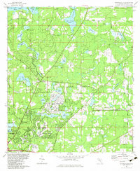 1982 Bradfordville1983 Print · USGSNorth of Tallahassee in the early eighties, this area shows a transition from rural homesteads to modern suburban expansion. Genealogists and local historians can locate many family-named landmarks including Bradford-Eppes Cem, Lester Island, and the St Philips Cem.
 - 1988 Map of Tallahassee
 1988 Tallahassee1988 Print · USGSThe Florida Panhandle and South Georgia are captured here in the late eighties, showing the expansion of the regional highway network and coastal growth. Genealogists and historians can trace rail lines like the Seaboard System Railroad or locate family roots in Blountstown, Graceville, or Crawfordville.2 unique versions available
End of results
Showing maps 1-5 of 5
Top cities near Tallahassee
Top neighborhoods of Tallahassee
- Macon historical maps
- Perkins historical maps
- Oak Knoll Estates historical maps
- Saint Peter historical maps
- Lafayette historical maps
- Four Points historical maps
See more
Frequently asked questions
- What are the different types of historical maps available for Tallahassee?
- What is the oldest map of Tallahassee?
- Where can I purchase historical maps of Tallahassee for my home or office?
- Where can I download high-res historical maps of Tallahassee?
- Are there historical topographic maps available for Tallahassee?
- Is there historical aerial imagery available for Tallahassee?
- Where are historical maps of Tallahassee sourced from?