1990s Maps of Miami-Dade County, Florida
Explore 16 historic maps of Miami-Dade County from the 1990s. These maps offer a rare glimpse into what life looked like during the 1990s — showing old roads, neighborhoods, homes, and landmarks that have changed or disappeared over time.
Whether you're researching your family's past, planning a metal detecting trip, or studying how Miami-Dade County's landscape evolved across the 1990s, these high-resolution maps are a powerful tool for exploring the history of this region.
- Focus on a specific era: All maps on this page are from the 1990s, giving you a focused view of this time period.
- See what’s changed: Compare century-old streets, trails, and buildings to today's modern landscape using overlays and satellite layers.
- Research with precision: Use these maps for genealogy, historical research, land use analysis, or educational projects.
- View, download, or print: Maps are fully viewable online in high resolution, and can be downloaded or printed for your own records.
Start exploring Miami-Dade County's history through authentic maps from the 1990s. This is your window into the past.
Miami-Dade County, FL maps
(16)- 1994 Map of Card Sound, 1998 Print
 1994 Card Sound1998 Print · USGSUpper Key Largo and the surrounding sounds appear in the mid-nineties as a mix of high-end coastal development and vast conservation lands. Researchers can trace the layout of the Ocean Reef Club or locate historic coastal landmarks like Dynamite Docks and the Short Bridge.
 - 1994 Map of Miami, 1999 Print
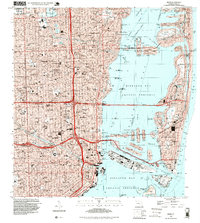 1994 Miami1999 Print · USGSGreater Miami in the mid-nineties shows a metropolis deeply integrated with the surrounding waters of the Biscayne Bay Aquatic Preserve. Researchers can locate historic landmarks like the Orange Bowl Stadium or trace the development of neighborhoods from Edison Center to Shenandoah.
 - 1994 Map of Glades, 1999 Print
 1994 Glades1999 Print · USGSIn the mid-1990s, the boundary between the Florida Everglades and the coastal sounds remained a vast landscape of managed canals and conservation areas. Researchers can trace the path of the South Dixie Highway as it cuts toward Barnes Sound and the Biscayne Bay Aquatic Preserve.
 - 1994 Map of Goulds, 1999 Print
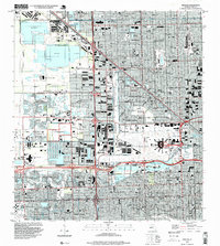
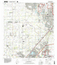 1994 Goulds1999 Print · USGSMiami-Dade County in the mid-nineties shows a transition from sprawling military and institutional facilities to dense suburban grids. Local researchers can locate dozens of private airfields like Lindbergh Landing Strip, family-named roads, and regional landmarks such as Metrozoo and Monkey Jungle.
 - 1994 Map of Homestead, 1999 Print
 1994 Homestead1999 Print · USGSSouthern Florida at the end of the twentieth century shows a landscape defined by rapid suburban growth and massive military installations. Local researchers can trace the development of Leisure City or locate community anchors like Sacred Heart Ch and Harris Field.
 - 1994 Map of Key Biscayne, 1999 Print
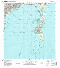 1994 Key Biscayne1999 Print · USGSBiscayne Bay and the Miami coastline are seen here in the mid-nineties, showing a landscape shaped by coastal preservation and urban expansion. Researchers can trace the development of Virginia Key and Key Biscayne through landmarks like the Seaquarium, St Agnes Sch, and the Old Lighthouse Tower.
 - 1994 Map of Hialeah, 1999 Print
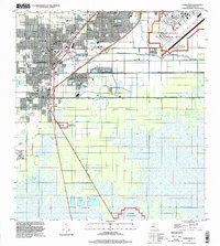
 1994 Hialeah1999 Print · USGSGreater Hialeah in the 1990s is captured here as a bustling intersection of aviation, industry, and suburbia. Researchers can trace the development of Hialeah Race Track, the massive Hialeah Yards, and local schools like Hialeah High Sch.
 - 1994 Map of Perrine, 1999 Print
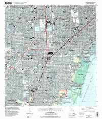
 1994 Perrine1999 Print · USGSThe coastal suburbs of South Miami in the 1990s are mapped here as residential grids expand toward the shores of BISCAYNE BAY. Local historians and genealogists can trace the growth of communities like Cutler Ridge, Goulds, and Franjo alongside schools like R R Moton Sch.
 - 1994 Map of South Miami, 2000 Print
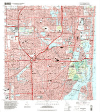
 1994 South Miami2000 Print · USGSCoastal Miami-Dade County in the mid-1990s shows a mature landscape of suburban expansion and significant institutional footprints. Researchers can trace the development of Coral Gables, the University of Miami campus, and local landmarks like the Venetian Pool and Dadeland Mall.
 - 1994 Map of North Miami, 2000 Print
 1994 North Miami2000 Print · USGSGreater Miami is captured here in the mid-nineties, showing a sprawling coastal landscape defined by luxury waterfront living and major sports venues. Researchers can trace the layout of Golden Beach and Ives Estates or locate landmarks like Joe Robbie Stadium and Aventura Mall.
 - 1994 Map of Pennsuco, 2000 Print
 1994 Pennsuco2000 Print · USGSFlorida's edge at the turn of the millennium shows the intersection of massive water management and suburban expansion. Trace the engineering of the Miami Canal and find local landmarks like the Opa-Locka West Airport and the Pennsuco Footbridge.
 - 1994 Map of South Miami NW, 2000 Print
 1994 South Miami NW2000 Print · USGSSuburban Miami-Dade County expanded westward toward the Everglades in the 1990s, creating a grid of residential lakes and canals. Researchers can trace local development through the layout of The Hammocks, the Tamiami Airport, and Richmond Heights.
 - 1995 Map of Fortymile Bend, 1999 Print
 1995 Fortymile Bend1999 Print · USGSThe Miccosukee heartland and the eastern Everglades are documented here in the mid-1990s. Researchers can trace family-named sites like Tommy Tigers Camp and Pete Oseolas Farm alongside the historic Old Burying Ground.
 - 1995 Map of North Of Fortymile Bend, 1999 Print
 1995 North Of Fortymile Bend1999 Print · USGSThe Florida Everglades in the mid-1990s reveal a landscape defined by indigenous residency and conservation boundaries. Genealogists and historians can locate specific sites like Mart Law Seminole Village, Sam Willie Seminole Village, and Sam Franks Old Farm.
 - 1995 Map of Hialeah SW, 2000 Print
 1995 Hialeah SW2000 Print · USGSGreater Miami's western edge meets the sawgrass frontier in the mid-nineties, showing where suburban growth confronts the Everglades. Locate local landmarks like Sweetwater, the Florida International University (Tamiami Campus), and the Our Lady of Mercy Cem alongside the engineered Tamiami Canal.
 - 1997 Map of Arsenicker Keys, 1998 Print
 1997 Arsenicker Keys1998 Print · USGSThe Florida coast near the close of the century reveals a unique landscape defined by massive industrial cooling systems and protected bay waters. Trace the intersection of the Turkey Point Nuclear Power Plant and the Biscayne National Park boundary.
End of results
Showing maps 1-16 of 16
Top cities of Miami-Dade County
- Miami historical maps
- Hialeah historical maps
- Kendall historical maps
- Miami Gardens historical maps
- Miami Beach historical maps
- Homestead historical maps
See more
Frequently asked questions
- What are the different types of historical maps available for Miami-Dade County?
- What is the oldest map of Miami-Dade County?
- Where can I purchase historical maps of Miami-Dade County for my home or office?
- Where can I download high-res historical maps of Miami-Dade County?
- Are there historical topographic maps available for Miami-Dade County?
- Is there historical aerial imagery available for Miami-Dade County?
- Where are historical maps of Miami-Dade County sourced from?