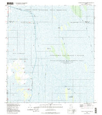
1995 Map of North Of Fortymile Bend
USGS Topo · Published 1999About this map
The Florida State Miccosukee Indian Reservation dominates the northern expanse of this landscape, situated at the intersection of several major conservation and wildlife areas. In the mid-1990s, this region of the Everglades shows the complex management of water and wilderness, where infrastructure like Levee 28 and the Tieback levee divide the Big Cypress National Preserve from the Everglades and Francis S Taylor State Wildlife Management Area. Human habitation is scattered and specialized, represented by the Mart Law Seminole Village and Sam Willie Seminole Village, alongside names like Sam Franks Old Farm and Panther Camp. The terrain is characterized by a network of airboat trails and the Sand Point Trail, providing passage through a wetland environment where water is impounded periodically.
Find a feature on this map
24 named features on this map. Tap any name to fly to it.
Don’t see what you’re looking for? This feature index may not catch every label — zoom into the map to look around manually.
Map Details
Editions of this 1995 North Of Fortymile Bend Map
This is the sole edition of this map. No revisions or reprints were ever made.
Other maps of this area

1956 · Miami
USGS Topo · 1:250,000

1956 · West Palm Beach
USGS Topo · 1:250,000

1957 · West Palm Beach
USGS Topo · 1:250,000

1958 · West Palm Beach
USGS Topo · 1:250,000

1958 · Miami
USGS Topo · 1:250,000

1973 · Fortymile Bend
USGS Topo · 1:24,000

1973 · Custard Apple Hammock
USGS Topo · 1:24,000

1973 · Fiftymile Bend
USGS Topo · 1:24,000

1973 · North Of Fiftymile Bend
USGS Topo · 1:24,000

1973 · Long Island
USGS Topo · 1:24,000