1980s Maps of Miami-Dade County, Florida
Explore 21 historic maps of Miami-Dade County from the 1980s. These maps offer a rare glimpse into what life looked like during the 1980s — showing old roads, neighborhoods, homes, and landmarks that have changed or disappeared over time.
Whether you're researching your family's past, planning a metal detecting trip, or studying how Miami-Dade County's landscape evolved across the 1980s, these high-resolution maps are a powerful tool for exploring the history of this region.
- Focus on a specific era: All maps on this page are from the 1980s, giving you a focused view of this time period.
- See what’s changed: Compare century-old streets, trails, and buildings to today's modern landscape using overlays and satellite layers.
- Research with precision: Use these maps for genealogy, historical research, land use analysis, or educational projects.
- View, download, or print: Maps are fully viewable online in high resolution, and can be downloaded or printed for your own records.
Start exploring Miami-Dade County's history through authentic maps from the 1980s. This is your window into the past.
Miami-Dade County, FL maps
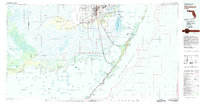
(21)- 1981 Map of Miami, 1982 Print
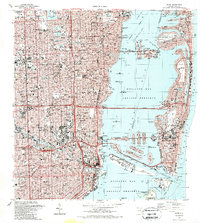
 1981 Miami1982 Print · USGSThe Miami metropolitan corridor and the vast marshlands of the interior are seen here in the early 1980s. Trace the reach of Florida's Turnpike and the Florida East Coast Railway past Opa-locka, Coral Gables, and the Miami International Airport.
 - 1982 Map of Homestead, 1983 Print
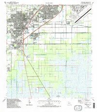
 1982 Homestead1983 Print · USGSThe transition from South Florida's citrus and military hubs to the wilderness of the Everglades is captured here in the early eighties. Researchers can trace the development of Homestead Air Force Base and find remote sites like the Royal Palm Ranger Station and Flamingo.2 unique versions available
 - 1988 Map of Pennsuco
 1988 Pennsuco1988 Print · USGSThe Florida Everglades meet the growing suburban edge of Broward and Dade Counties in the late eighties. Researchers can trace water management history and local industry through features like the Miami Canal No C-6, the Opa-Locka West Airport, and the industrial quarries near Pennsuco.2 unique versions available
 - 1988 Map of Elliott Key
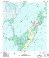
 1988 Elliott Key1988 Print · USGSThe Florida Keys within Biscayne National Park are mapped here in the 1980s, showing the delicate balance of land and sea. Trace the shoreline from University Dock down to the narrow channels of Caesar Creek and Porgy Key.
 - 1988 Map of Miami
 1988 Miami1988 Print · USGSSouth Florida in the late eighties shows the sharp edge between the growing urban Atlantic coast and the vast wetlands of Everglades National Park. Researchers can trace the path of the Tamiami Trail and locate coastal settlements like Ochopee or Chokoloskee.
 - 1988 Map of Key Biscayne
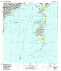 1988 Key Biscayne1988 Print · USGSMiami and the northern Keys are captured in the late eighties as urban growth met protected coastal waters. Researchers can trace the layout of Coconut Grove or find local landmarks like St Agnes Sch and the Old Lighthouse Tower.
 - 1988 Map of South Miami
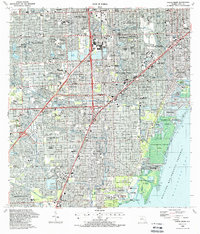 1988 South Miami1988 Print · USGSCoastal Miami-Dade County comes alive in the late eighties as suburban growth transforms former agricultural lands into bustling neighborhoods. Trace family roots and local development through landmarks like Dadeland Mall, The Falls Mall, and the historic Venetian Pool.
 - 1988 Map of Soldier Key
 1988 Soldier Key1988 Print · USGSCoastal Miami-Dade in the late eighties reveals a landscape of preservation and maritime navigation. Researchers can trace the layout of Islandia, locate navigation Lights, and explore island features like Boca Chita Key and the Ragged Keys.
 - 1988 Map of South Miami NW
 1988 South Miami NW1988 Print · USGSSuburban Miami-Dade expands rapidly during the late eighties, showing a landscape defined by residential growth and major infrastructure. Researchers can trace development around The Hammocks, Tamiami Airport, and Richmond Heights.
 - 1988 Map of Opa-Locka
 1988 Opa-Locka1988 Print · USGSNorth Dade and South Broward counties come into focus during a period of rapid suburban maturation in the late eighties. Genealogists and local historians can trace the development of Miami Lakes and Carol City, identifying neighborhood landmarks like Florida Memorial College and Vista Memorial Gardens.
 - 1988 Map of Glades
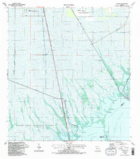 1988 Glades1988 Print · USGSThe southern Florida wetlands meet the coast in the late eighties, showing a landscape defined by conservation and complex drainage. Trace the routes of the South Dixie Highway and Card Sound Road past Narrow Point and Manatee Bay.2 unique versions available
 - 1988 Map of Miami
 1988 Miami1988 Print · USGSGreater Miami flourished as a global gateway by the late eighties, spanning from the mainland neighborhoods to the artificial islands of the bay. You can trace urban expansion and maritime infrastructure through landmarks like the Orange Bowl Stadium, Lincoln Mem Park (Cem), and the Seaboard System rail lines.2 unique versions available
 - 1988 Map of Perrine
 1988 Perrine1988 Print · USGSCoastal Dade County undergoes significant residential growth during the late eighties, as suburban neighborhoods expand toward the mangrove shorelines. Genealogists and historians can trace local development through the grids of Perrine, Goulds, and Cutler Ridge alongside landmarks like Richmond Sch.
 - 1988 Map of Homestead
 1988 Homestead1988 Print · USGSSouthern Florida at the end of the eighties shows a landscape of rapid suburban growth defined by military installations and vital drainage canals. Genealogists and historians can locate specific neighborhood sites like Sacred Heart Ch, Modello, and the original footprint of Homestead Air Force Base.2 unique versions available
 - 1988 Map of Pacific Reef
 1988 Pacific Reef1988 Print · USGSThe northern Florida Keys and their surrounding coral reefs are mapped here in the late eighties, documenting a critical marine environment. Researchers can trace the maritime boundaries of Biscayne National Park and locate offshore features like the Pacific Reef Lighthouse and Turtle Reef.
 - 1988 Map of Hialeah
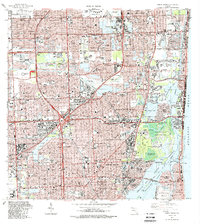
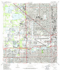 1988 Hialeah1988 Print · USGSMiami-Dade County in the late eighties shows a landscape shaped by rapid suburban expansion and massive infrastructure. Genealogists and local historians can trace the development of Hialeah and Sweetwater, locating sites like Flagler Mem Park Cem and the Hialeah Speedway.
 - 1988 Map of Goulds
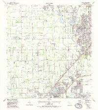 1988 Goulds1988 Print · USGSSouthern Dade County's landscape comes into focus during the late eighties, showcasing the intersection of military operations and tropical tourism. Genealogists and locals can trace the sites of Aladdin City, Palm Mem Cem, and the specialized Robert Morgan Vo-Tech Sch.
 - 1988 Map of Hialeah SW
 1988 Hialeah SW1988 Print · USGSThe Miami-Dade wetlands met suburban expansion in the late eighties, showing a landscape of massive quarries and new institutional hubs. Trace the development of Sweetwater and facilities like the South Florida Reception Center.
 - 1988 Map of Card Sound
 1988 Card Sound1988 Print · USGSUpper Key Largo and the surrounding sounds are captured in the late eighties during a period of refined coastal development. Trace the footprints of private communities like Ocean Reef Club and Grayvik alongside protected lands like Crocodile Lake National Wildlife Refuge.2 unique versions available
 - 1988 Map of North Miami
 1988 North Miami1988 Print · USGSNorth Miami and the surrounding Broward-Dade borderlands are shown here in the late eighties during a period of massive residential and commercial growth. Researchers can trace the development of Ives Estates and Carol City or locate landmarks like Joe Robbie Stadium and Barry University.
 - 1988 Map of Arsenicker Keys
 1988 Arsenicker Keys1988 Print · USGSThe Dade County coastline in the late eighties shows a striking contrast between industrial utility and marine preservation. Researchers can trace the massive Cooling Canals at Turkey Point and the remote Arsenicker Key island group.
End of results
Showing maps 1-21 of 21
Top cities of Miami-Dade County
- Miami historical maps
- Hialeah historical maps
- Kendall historical maps
- Miami Gardens historical maps
- Miami Beach historical maps
- Homestead historical maps
See more
Frequently asked questions
- What are the different types of historical maps available for Miami-Dade County?
- What is the oldest map of Miami-Dade County?
- Where can I purchase historical maps of Miami-Dade County for my home or office?
- Where can I download high-res historical maps of Miami-Dade County?
- Are there historical topographic maps available for Miami-Dade County?
- Is there historical aerial imagery available for Miami-Dade County?
- Where are historical maps of Miami-Dade County sourced from?