Old Maps of Union County, Florida for Metal Detecting
Plan your next treasure hunt with 72 historic maps of Union County. Find old homesites, ghost towns, trails, and gathering spots that may be lost to time — perfect for identifying promising metal detecting locations.
- Locate forgotten sites: Uncover places like long-lost settlements, abandoned rail lines, or gathering spots.
- Plan better hunts: Use map overlays combined with LiDAR or satellite views to narrow in on historically rich areas.
- Made for detectorists: Thousands of hobbyists use these maps to discover relics, coins, and hidden history.
Use these historic maps to boost your research and find new opportunities beneath the surface of Union County.
Union County, FL maps
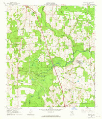
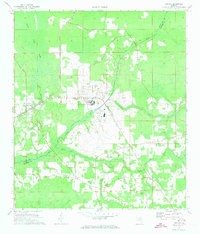
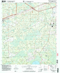
(72)- 1918 Map of Lawtey
 1918 Lawtey1918 Print · USGSFlorida's northern interior during the First World War reveals a landscape of isolated farmsteads and growing rail towns. Researchers can locate early schoolhouses like Ben Rowe School and Vanderbilt School or trace the early footprint of the Bradford Farms (State Prison).5 unique versions available
 - 1954 Map of Gainesville, 1965 Print
 1954 Gainesville1965 Print · USGSMid-century North Central Florida comes into focus as a landscape of timber, rails, and river towns along the Gulf. Trace family roots in established centers like Gainesville or follow the path of the Suwannee River to the coastal docks of Cedar Key.3 unique versions available
 - 1954 Map of Valdosta, 1967 Print
 1954 Valdosta1967 Print · USGSThe South Georgia and North Florida borderlands are captured here in the mid-fifties, showing the deep timber and wetland networks of the coastal plain. Researchers can trace the path of the Atlantic Coast Line through Valdosta or explore the interior of the Okefenokee Swamp.2 unique versions available
 - 1958 Map of Valdosta
 1958 Valdosta1958 Print · USGSSouth Georgia and North Florida are captured here in the mid-fifties, showing the vast Okefenokee Swamp and the vital timber and rail corridors connecting the two states. Researchers can locate the footprint of Moody Air Force Base, trace the Live Oak Perry and Gulf railroad, or find early community sites like Bakers Mill and Paradise Church.
 - 1958 Map of Gainesville
 1958 Gainesville1958 Print · USGSNorth Central Florida’s rail and river networks are frozen in time just before the interstate era. Genealogists and historians can trace the paths of the Atlantic Coast Line through Gainesville or locate coastal settlements like Steinhatchee and Cedar Key.
 - 1959 Map of Valdosta
 1959 Valdosta1959 Print · USGSThe Georgia-Florida borderlands in the mid-fifties reveal a landscape of massive blackwater swamps and emerging military aviation hubs. Genealogists and historians can trace rail-stop towns like Fargo and Stockton or explore the interior reaches of the Okefenokee Swamp and Billys Island.
 - 1959 Map of Gainesville
 1959 Gainesville1959 Print · USGSNorth Florida in the mid-fifties is seen here from the Gulf coast to the inland lakes, showing the rail-and-river network before modern highways dominated. Researchers can trace the paths of the Seaboard Air Line through towns like Chiefland and Micanopy, or explore the coastal inlets of Waccasassa Bay.
 - 1962 Map of Mikesville, 1964 Print
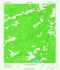
 1962 Mikesville1964 Print · USGSColumbia County in the early sixties was a landscape of quiet crossroads and riverside parks. Researchers can trace family roots through numerous local landmarks like Mikesville Ch, Bland, and the unique Sky Road Inn Airfield.3 unique versions available
 - 1963 Map of Olustee, 1964 Print
 1963 Olustee1964 Print · USGSBaker County at the dawn of the sixties remains a landscape of dense pine woods and significant Civil War heritage. Researchers can trace the rail lines of the Seaboard Air Line or locate family sites near Dyess Cem and the Olustee Battlefield State Mon.3 unique versions available
 - 1963 Map of Sanderson South, 1964 Print
 1963 Sanderson South1964 Print · USGSNorth Florida's timber and rail country is captured in the early sixties, showing the vital connection between the Osceola National Forest and the Seaboard Air Line. Genealogists can locate the Bethlehem Cem and trace early crossroads near Sanderson and Manns Spur.2 unique versions available
 - 1963 Map of Ellisville, 1964 Print
 1963 Ellisville1964 Print · USGSNorth-central Florida's rural landscape is captured here in the early sixties, showing a world of small timber-and-farm settlements. Genealogists can trace family roots at Hopeful Cem, Farnell Cem, and the community of Myrtis.2 unique versions available
 - 1966 Map of Lake Butler
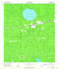
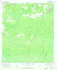
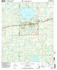
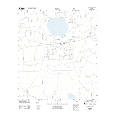
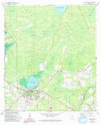 1966 Lake Butler1966 Print · USGSLake Butler and its surrounding Union County wetlands are captured here in the mid-sixties, showing a landscape shaped by timber and water. Genealogists can trace family landmarks like Varnes Cemetery or the community at Johnstown, while explorers can follow the Old Railroad Grade and Richard Millpond.3 unique versions available
 - 1966 Map of Worthington Springs, 1967 Print
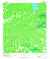
 1966 Worthington Springs1967 Print · USGSNorth central Florida’s river-crossing communities are documented here in the mid-1960s, showing a landscape of small hamlets and riverside industry. Genealogists can trace family landmarks at Bethany Cem or Fort Call Cem and follow the old Atlantic Coast Line rail route through Worthington Springs.
 - 1966 Map of Lulu, 1967 Print
 1966 Lulu1967 Print · USGSFlorida's interior timberlands come into focus in the mid-1960s, showing the rural rail corridor between Lulu and Cliftonville. Genealogists can locate Gillen-Allen Cem, Oak Grove Ch, and the isolated turpentine site at Shaws Still near Swift Creek.2 unique versions available
 - 1966 Map of Brooker, 1967 Print
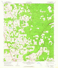
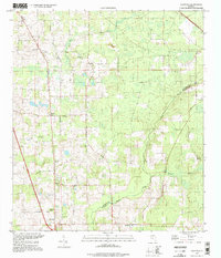
 1966 Brooker1967 Print · USGSBrooker and the New River basin are shown in the mid-1960s, documenting a landscape of rural settlements and timberlands. Researchers can locate family-named landmarks like Dekles Millpond, the Dedan Cem, and several local churches including Long Bridge Ch.4 unique versions available
 - 1970 Map of Raiford, 1973 Print
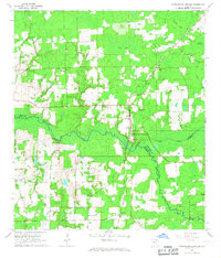
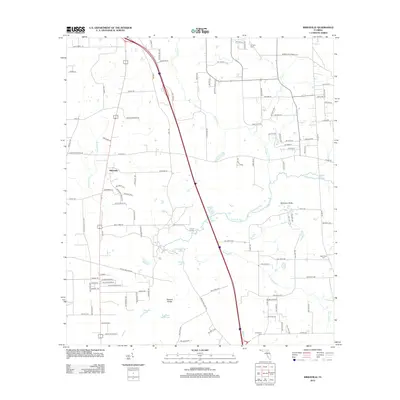
 1970 Raiford1973 Print · USGSUnion and Bradford counties are captured here in the early seventies, showcasing a landscape of institutional history and rural community life. Researchers can locate family landmarks such as Evergreen Ch, Pine Grove Cem, and the massive Florida State Prison complex.2 unique versions available
 - 1970 Map of Manning, 1973 Print
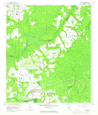
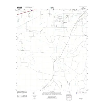
 1970 Manning1973 Print · USGSBaker and Union counties are shown here in the early 1970s, a landscape shaped by the Seaboard Coast Line and the Northeast Florida State Hospital. Genealogists can trace rural communities like Sapp, Manning, and Steckert alongside landmarks like Manntown Ch.
 - 1981 Map of Lake City
 1981 Lake City1981 Print · USGSNorth Florida and South Georgia are mapped in the early eighties as the region balanced forestry with growing infrastructure. Genealogists can trace family names and locations from Live Oak to Macclenny, or find cultural landmarks like the Stephen Foster State Folk Culture Center.2 unique versions available
 - 1981 Map of Gainesville, 1982 Print
 1981 Gainesville1982 Print · USGSGainesville and its surrounding North Central Florida counties are captured in the early eighties, showcasing a mix of university growth and rural agriculture. Genealogists and historians can trace small settlements like Arredondo, Wacahoota, and Island Grove alongside major rail lines like the Seaboard Coast Line.2 unique versions available
 - 1994 Map of Ellisville, 1998 Print
 1994 Ellisville1998 Print · USGSColumbia County in the mid-1990s remains a landscape of quiet rural settlements and winding waterways. Genealogists and local historians can locate many family burial grounds and community landmarks like Hopeful Ch Cemetery, Mt Tabor, and the Rose Creek Lookout Tower.
 - 2005 Map of Olustee, 2006 Print
 2005 Olustee2006 Print · USGSBaker County at the start of the 21st century remains a landscape of managed timberlands and significant Civil War heritage. Local historians can trace the grounds of the Olustee Battlefield Hist Site or locate family markers at Dyess Cem and Monument Cem.
 - 2005 Map of Sanderson South, 2006 Print
 2005 Sanderson South2006 Print · USGSThe wetlands of Baker County are captured here at the turn of the millennium, revealing a landscape shaped by the Osceola National Forest. Researchers can find the South Prong Cem and Bethlehem Ch near the banks of the St Marys River.
 - 2012 Map of Mikesville, 2012 Print
 2012 Mikesville2012 Print · USGSCovers Union County, including Mikesville, Alachua County, and other nearby areas
 - 2012 Map of Olustee, 2012 Print
 2012 Olustee2012 Print · USGSCovers Union County, including Olustee, Columbia County, and other nearby areas
 - 2012 Map of Manning, 2012 Print
 2012 Manning2012 Print · USGSCovers Union County, including Macclenny, Manning, and other nearby areas
Showing maps 1-25 of 72
Top cities of Union County
Frequently asked questions
- What are the different types of historical maps available for Union County?
- What is the oldest map of Union County?
- Where can I purchase historical maps of Union County for my home or office?
- Where can I download high-res historical maps of Union County?
- Are there historical topographic maps available for Union County?
- Is there historical aerial imagery available for Union County?
- Where are historical maps of Union County sourced from?